Maps of China
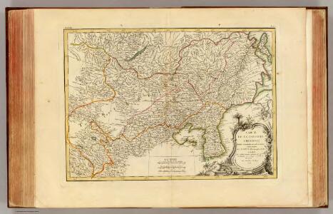
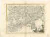
Tartarie Chinoise.
1 : 10400000 Bonne, Rigobert, 1727-1794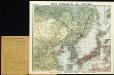
New war map of East Asia
La Tartaria chinese
Tartarie, Chinoise, roy de Corée et isles du Japon
1 : 12640000 Japonsko Bonne, Rigobert
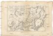
Thibet, Mongolia, and Mandchouria.
1 : 19008000 Tallis, J. & F.
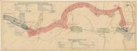
Teatr voennych dějstvīj v 1904 - 1905 godach
China Russisch-Japanischer Krieg
Russia in Asia 3, Chinese Empire.
1 : 10454400 Letts, Son & Co.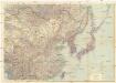
Ostasien
1 : 5000000 Asie východní Justus Perthes
Die Kriegsschauplätze in Ostasien
1 : 10000000 Asie jihovýchodní Velhagen & Klasing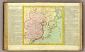
La Chine, Coree, Japon.
1 : 14300000 Clouet, J. B. L. (Jean-Baptiste Louis), b. 1730
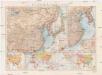
Siberia, Chinese Tartary.
1 : 11000000 Society for the Diffusion of Useful Knowledge (Great Britain)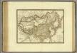
Empire Chinois, Japon.
1 : 13600000 Brue, Adrien Hubert, 1786-1832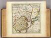
Empire of China, island of Japan.
1 : 18000000 Moll, Herman, d. 1732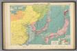
Chinese, Japanese ports.
1 : 10000000 Philip, George
Neue Kriegskarte von Ost Asien
Politische Karte von China
1 : 10000000 Japonsko Scobel, Albert Velhagen & Klasing
Schauplatz der Ereignisse in Ost - Asien

中華民國現勢圖
1 : 10000000 中華民國現勢圖 昭和十二年[1937]7月20日,鐵道省運輸局编纂,东京:东京朝日新聞社 增补发行 为中国省级行政区划图,由于此图系日本绘制,东北伪满洲国被绘在国界线外。图上绘制了省级争取分界线、铁路、公路和航空线路等。按照20世纪三十年代的制图水准看,此图的绘制精度较差,不论是省界还是海岸线都存在较大偏差。 插图1幅:《北平附近圖》,主要绘制冀东地区傀儡政权和卢沟桥附近地形图。另有2表:《中國國民黨及國民政府組織(附)》和《中國の陸軍及び空軍》,内容为民国党政机构架构和军力数据。 1图,彩色,日文,图幅53.8 x 71.6 cm,比例尺1:10,000,000,经纬度为E75°-140°; N18°-55°。 Harvard-YenchingManchuguo J-0817;Hollis Number:014622127 鐵道省運輸局 东京朝日新聞社
韓國輿地圖:中國
Manuscript. Imprint date from postscript. 金鴻圭
天下輿地圖:中國圖
天下輿地圖 明清时期 该图集为李氏朝鲜时期舆图,前有《天下圖》和《中國圖》各一幅,后为朝鲜八道图及日本图。封面题有“玄黓執徐腊下瀚”,可能是壬辰年十二月下旬,但具体年份待定。内容与形态基本与上图相同(005833853),《天下圖》反映中国传统天下观,中国居中,周围岛国取自《山海经》,《中國圖》绘制明朝两京十三省。 1图,彩绘,中文,图幅27.8 x 34.3 cm。 Harvard-Yenching | Rare Book | TK 3490.7 1174;Hollis Number:009140732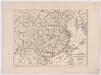
Karte von China mit dessen Eintheilung in 18 Provinzen
1 : 6500000 Roost, J. B Verlag der liter. artist. Anstalt der L.G. Cotta'schen Buchhandlung
Čínská říše
1 : 18500000 Čína Otto, Jan J. Otto

Asia (Eastern Sheet).
1 : 14606000 Fisher, Richard Swainson
地理志略:大清國圖
地理志略 1903年,Alice S. Parker 此为用厦门闽南方言表述、罗马拼音书写的世界地理介绍性著作,介绍了清朝地理和世界六大洲地理概况。内有《大清國》图和《十八省》图,分别为全清和内地省级行政区划图。 2图,彩色,厦门方言罗马拼音,19.8 x 22.8 cm Harvard-Yenching | Rare Book | TA 2380 68.1,Hollis Number:008161903
天下九邊萬國人跡路程全圖
天下九邊萬國人跡路程全圖 康熙二年(1663年),姑苏王君甫 此图按内容上属于世界地图,主体部分刻绘了明朝两京十三省府、州、县及边镇卫所等。图东北方绘制了大东洋和美洲(加拿太国和古巴岛等),东南方绘制了日本国、毛人国、女人国、川心国等,该图对南方的绘制方位变形很大,福建已到图下方,该方位的海面有琉球国、三首国、三身国、金齿国等;图西南方向则有大食、槟榔、吕蒙等以及黄河源头昆仑山附近的葫芦形湖泊“星宿海”;图西北方则为大西洋、非洲和欧洲,标注了泥禄河、地中海、佛沙国等;北部则标注了鞑靼等地。这反映明清之际人们对世界的认识。全图由八块刻板拼印而成,有较明显的拼接痕迹。 图上方为题记,左侧罗列外国名称及简介,右侧罗列边疆重要卫所和关隘,下方是题为《天下京省九边外国府州县路程图》的各省文字解说,内容包括两京十三省的地理方位、历史沿革、户口数、米麦、绢丝棉麻、盐引数等统计数据,同时附有两京十三省下辖府县数及到其他省份的里程。 图上府用正方形,着红色;县用椭圆形,着黄色;州及西南土州、土府、长官司等用长方形,着深褐色;卫所用菱形,着浅褐色。大洋、河流、湖泊等水域绘有波纹。 本图为民间私刻,内容和形制上与明万历二十一年梁辀镌刻的《乾坤萬國全圖古今人物事蹟》、明崇祯十七年曹君义刻印的《天下九邊分野人跡路程全圖》、明末季名台刻印的《九州分野輿圖古今人物事跡》等图相似,应有较强的传承关系。在本图成图之后,日本帝幾書坊梅村彌白曾翻刻了王君甫的这张图,将图题和图下解说中的“天下”改为“大明”,称为《大明九邊萬國人跡路程全圖》,除此以外,内容完全一致,只是图上府、州、县、卫所等未着色而已,可以说是本图的复印件。 1图,刻本,彩色,中文,125 x 122.5 cm Harvard-Yenching | Rare Book | T 3080 4643,Hollis Number:008690193 姑蘇:王君甫
Carte des missions catholiques en Chine
1 : 5500000 Launay, Adrien 1853-1927 [Lyon : Oeuvre de la propagation de la foi]
Political Map of China showing Christian Mission Stations

111-112. Mongolian People's Republic, North China. The World Atlas.
1 : 5000000 USSR (Union of Soviet Socialist Republics).