Maps of China

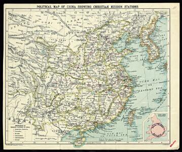
Political Map of China showing Christian Mission Stations

Čínská říše
1 : 18500000 Čína Otto, Jan J. Otto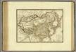
Empire Chinois, Japon.
1 : 13600000 Brue, Adrien Hubert, 1786-1832
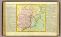
Carte des missions catholiques en Chine
1 : 5500000 Launay, Adrien 1853-1927 [Lyon : Oeuvre de la propagation de la foi]
IMPERII | SINARVM | NOVA DESCRIPTIO
[Amsterdam : Joan Blaeu]
China Veteribus Sinarum Regio nunc Incolis Tame dicta. [Karte], in: Le théâtre du monde, ou, Nouvel atlas contenant les chartes et descriptions de tous les païs de la terre, Bd. 2, S. 252.
1 Karte aus Atlas Blaeu, Willem Janszoon und Blaeu, Joan Blaeu, Willem Janszoon
Imperii Sinarum Nova Descriptio [Karte], in: Novus atlas absolutissimus, Bd. 11, S. 14.
1 Karte aus Atlas Janssonius Offizin
CARTE DE LE'EMPIRE DE LA CHINE

Imperii Sinarum Nova Descriptio. [Karte], in: Novus atlas Sinensis, S. 16.
1 Karte aus Atlas Martini, Martino Blaeu, Joan
China Veteribus Sinarum Regio nunc Incolis Tame dicta. [Karte], in: Novus Atlas, das ist, Weltbeschreibung, Bd. 2, S. 274.
1 Karte aus Atlas Blaeu, Joan Blaeu, Willem Janszoon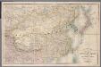
[Kaart], uit: Stanford's map of the empires of China and Japan : with the adjacent parts of the Russian Empire, India, Burma &c
1 : 6000000 titelvariant: Stanford's map of China & Japan; Annotatie: Omslagtitel: Stanford's map of China & Japan London : Stanford
Chinesisches Reich
Adolf Stieler's Handatlas über alle Theile der Erde und über das Weltgebäude Stieler, Adolf Justus Perthes
108-109. China, Mongolia, Korea. The World Atlas.
1 : 10000000 USSR (Union of Soviet Socialist Republics).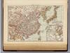
China, Japan.
1 : 15000000 Andree, Richard; Times (London, England)
China and Japan.
1 : 15000000 Andree, Richard
Imperii Sinarum nova descriptio
1 : 8000000 Amstelodami : ex officina J. Cóvens et C. Mortier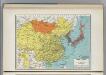
China and Japan.
1 : 15474000 Hammond, C.S.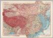
Mongolia and China. Pergamon World Atlas.
1 : 10000000 Polish Army Topography Service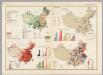
China. Pergamon World Atlas.
Polish Army Topography Service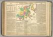
China and Japan.
1 : 13000000 Lavoisne, M.
China
1 : 9500000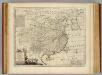
China.
1 : 10200000 Bowen, Emanuel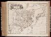
Imperii Sinarvm nova descriptio
1 : 8000000 Annotatie: Cum privilegio Sacrae Caesareae Majestatis & Ordinum Belgicae Foederatae; Origineel is Blad 196 in atlas factice [Amsterdam : J. Blaeu]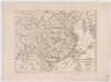
Karte von China mit dessen Eintheilung in 18 Provinzen
1 : 6500000 Roost, J. B Verlag der liter. artist. Anstalt der L.G. Cotta'schen Buchhandlung
La Chine, Coree, Japon.
1 : 14300000 Clouet, J. B. L. (Jean-Baptiste Louis), b. 1730
Carte generale de la Chine

Carte industrielle de la Chine, contenant les lignes ferrées & lignes télégraphiques construites, concédées & probables, les mines & usines connues ...
1 : 4625000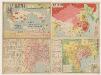
廣東香港明細地圖. 漢口南昌明細地圖
1 : 820000 廣東香港明細地圖•漢口南昌明細地圖 昭和十三年[1938]3月1日,淵田忠良 编辑,东京:大日本雄辯會講談社 正面为《廣東香港明細地圖》,以珠三角为中心的行政图,包括香港,绘制了铁路、公路、河网和航空线,标注了县治及部分乡镇地名。附插图3幅:《汕頭附近》,为粤东地区行政区划图;《廣東》,为广州城地形简图;《香港》为维多利亚海湾两岸等高线地形图。 背面为《漢口南昌明細地圖》,西起洞庭湖,东至太湖西侧,南抵湖南、江西中部的湘潭-抚州一线,北达南京、信阳一带,以长江中游汉口-南昌-南京为中心,包括洞庭湖、鄱阳湖、巢湖等。绘制了该区域较为详细的村镇地名和交通线。 背面的汉口图较广东图详细,应与此时日军正大举进攻长江中游,并即将发动武汉会战的战争局势密切相关。 2图,黑蓝双色,日文,图幅39.5 x 54.5 cm,比例尺分别为1:820,000和1:1,500,000,无经纬线。 Harvard-YenchingManchuguo J-0886;Hollis Number:014636952 淵田忠良 大日本雄辯會講談社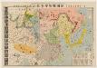
北支事變明細圖解 : 日·満·露·支·蒙·関係一覽.
北支事變明細圖解 昭和十二年[1937]8月22日 东京:東京日日新聞社 此图是在《東亜危機明細図解》(014623780)上修改而成,主图内容是1937年中国的军事形势,东北地区中苏边界上,苏联部署重兵包围了伪满洲国。华北地区沦陷并成立了冀东傀儡政权。国民党主要控制淮河以南地区。 插图1幅《北支事變要圖》。 1图,彩色,日文,图幅53.6 x 77.2 cm,无比例尺和经纬线。 Harvard-YenchingManchuguo J-0828;Hollis Number:014623845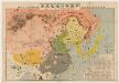
東亜危機明細図解 : 恐るべし日満包囲馬蹄陣形 : 日満露支蒙関係一覧.
東亜危機明細図解:恐るべし日満包囲馬蹄陣形 昭和十一年[1936]10月10日,东京:东京日日新聞社 该图标示出苏联红军重兵包围东北,沿着东北中苏边界修筑防线,进而形成对东北和华北地区的马蹄形包围。同时,苏联从西北方向中国输送物质弹药,西北地区已赤化,并不断向东推进。华北地区则有多个国民党军头控制,淮河以南地区除了广西外,主要由蒋介石中央政府控制,并向北推进。该图用图画标注各地主要物产,并用贴了各地军政首脑头像。 1图,彩色,日文,图幅53.5 x 77.6 cm,无比例尺和经纬度线。 Harvard-YenchingManchuguo J-0822;Hollis Number:014623780 东京日日新聞社