Maps of White Plains
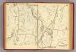
44-45 White Plains.
1 : 10800 G.W. Bromley & Co.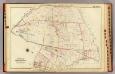
White Plains.
1 : 7200 Bromley, George Washington; Bromley, Walter Scott; G.W. Bromley & Co.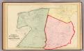
Scarsdale, White Plains.
1 : 14400 Bromley, George Washington; Bromley, Walter Scott; G.W. Bromley & Co.
White Plains, Scarsdale towns.
1 : 31680 Beers, F. W. (Frederick W.)
Scarsdale, New Rochelle, Mamaroneck towns.
1 : 21120 Bien, Joseph Rudolf
Glenville
1 : 24000
Glenville
1 : 24000
Glenville
1 : 24000
Glenville
1 : 24000
Glenville
1 : 31680
Glenville
1 : 24000
Glenville
1 : 24000
Glenville
1 : 24000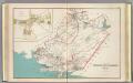
White Plains, Harrison, Rye towns.
1 : 27600 Bien, Joseph Rudolf
Harrison, Rye towns.
1 : 31680 Beers, F. W. (Frederick W.)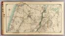
6 Atlas rural country district north of New York City.
1 : 15000 Hyde, E. Belcher
Town of Rye, Westerchester Co. N.Y.
from County atlas of Westchester, New York. Published by J.B. Beers & Co., assisted by S.W. Wilson and others.
Town of Rye, Westerchester Co. N.Y.
from County atlas of Westchester, New York. Published by J.B. Beers & Co., assisted by S.W. Wilson and others.
Plates 53 & 54: Town of New Rochelle, Westchester Co. N.Y. - Town of Pelham, Westchester Co. N.Y. - City Island, Pelham Township, Westchester Co. N.Y.
from County atlas of Westchester, New York. Published by J.B. Beers & Co., assisted by S.W. Wilson and others.
5. Larchmont-Kensico Sta.-Hartsdale-Greenwich.
1 : 80000 Servoss, R. D.
Plate 68: Town of White Plains, Westchester Co. N.Y. - Town of Scarsdale, Westchester Co. N.Y.
from County atlas of Westchester, New York. Published by J.B. Beers & Co., assisted by S.W. Wilson and others.
Small folder - S1
from Atlas of New York and vicinity : from actual surveys / by and under the direction of F. W. Beers, assisted by A. B. Prindle & others
5. Larchmont-Kensico Sta.-Hartsdale-Greenwich.
1 : 80000 Servoss, R. D.
Map of Westchester Co.
1 : 45000 G.W. Bromley & Co.
Town of Greenwich, Fairfield County, Connecticut.
1 : 38169 Beers, Frederick W.
31. Stamford sheet.
1 : 62500 Geological Survey (U.S.)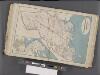
Westchester, Double Page Plate No. 13 [Map of Towns of Scarsdale, New Rochelle, and Mamaroneck] / prepared under the direction of Joseph R. Bien, from general surveys and official records.
From Atlas of Westchester County, New York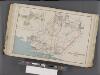
Westchester, Double Page Plate No. 17 [Map of Towns of White Plains, Harrison, and Rye] / prepared under the direction of Joseph R. Bien, from general surveys and official records.
From Atlas of Westchester County, New York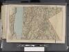
Westchester, Double Page Plate [Map of Westchester County, Irvington, Tarry Town to Sing Sing, East to State Line] / prepared under the direction of Joseph R. Bien, from general surveys and official records.
From Atlas of Westchester County, New York


