Maps of Greenwich
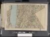
Westchester, Double Page Plate [Map of Westchester County, Irvington, Tarry Town to Sing Sing, East to State Line] / prepared under the direction of Joseph R. Bien, from general surveys and official records.
From Atlas of Westchester County, New York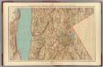
Westchester Co., Irvington-state line.
1 : 31680 Vermeule, C. C. (Cornelius Clarkson), 1858-1950
North part of Town of Mount Pleasant - Pleasantville.
from County atlas of Westchester, New York. Published by J.B. Beers & Co., assisted by S.W. Wilson and others.
Tarrytown
1 : 62500
Tarrytown
1 : 62500
Tarrytown
1 : 62500
Tarrytown
1 : 62500
Tarrytown
1 : 62500
Tarrytown
1 : 62500
Tarrytown
1 : 62500
Tarrytown
1 : 62500
Tarrytown
1 : 62500
Tarrytown
1 : 62500
Plate 30: Town of Greenburgh, Westchester Co. N.Y.
from Atlas of New York and vicinity : from actual surveys / by and under the direction of F. W. Beers, assisted by A. B. Prindle & others
Westchester, Double Page Plate No. 20 [Map of town of Greenburg] / prepared under the direction of Joseph R. Bien, from general surveys and official records.
From Atlas of Westchester County, New York
Plate 73: Town of Newcastle, Westchester Co. N.Y.
from County atlas of Westchester, New York. Published by J.B. Beers & Co., assisted by S.W. Wilson and others.
Town of Rye, Westerchester Co. N.Y.
from County atlas of Westchester, New York. Published by J.B. Beers & Co., assisted by S.W. Wilson and others.
4. Yonkers-Tarrytown-Hartsdale.
1 : 80000 Servoss, R. D.
Plate 68: Town of White Plains, Westchester Co. N.Y. - Town of Scarsdale, Westchester Co. N.Y.
from County atlas of Westchester, New York. Published by J.B. Beers & Co., assisted by S.W. Wilson and others.
5. Larchmont-Kensico Sta.-Hartsdale-Greenwich.
1 : 80000 Servoss, R. D.
Small folder - S1
from Atlas of New York and vicinity : from actual surveys / by and under the direction of F. W. Beers, assisted by A. B. Prindle & others
4. Yonkers-Tarrytown-Hartsdale.
1 : 80000 Servoss, R. D.
Town of Greenwich, Fairfield County, Connecticut.
1 : 38169 Beers, Frederick W.
7. Tarrytown-Oscawana-Merritt's Corners.
1 : 80000 Servoss, R. D.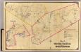
7 North Castle, New Castle.
1 : 18000 Hyde & Company
8. Kensico-Mt. Kisco-Pleasantville-Bedford.
1 : 80000 Servoss, R. D.
6 Atlas rural country district north of New York City.
1 : 15000 Hyde, E. Belcher
North part of Town of Mount Pleasant - Pleasantville.
from County atlas of Westchester, New York. Published by J.B. Beers & Co., assisted by S.W. Wilson and others.
Town of Greenburgh, Westchester County, New York.
1 : 42240 Beers, Frederick W.
![Westchester, Double Page Plate [Map of Westchester County, Irvington, Tarry Town to Sing Sing, East to State Line] / prepared under the direction of Joseph R. Bien, from general surveys and official records.](https://images-0.georeferencer.com/images/iiif/981996592454/full/,300/0/native.jpg)

