Maps of India
India S.
1 : 4457000 Johnston, Alexander Keith, 1804-1871
Asia (Southern sheet).
1 : 14606000 Fisher, Richard Swainson
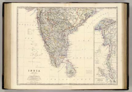
Composite: India.
1 : 4457000 Johnston, Alexander Keith, 1804-1871
Hindostan Or British India.
1 : 14889600 Johnson, A.J.
Composite: India.
1 : 4457000 Johnston, Alexander Keith
Hindostan Or British India.
1 : 14630000 Johnson, A.J.
Ad antiquam Indiae geographiam tabula.
1 : 11300000 Anville, Jean Baptiste Bourguignon d, 1697-1782
India South.
1 : 5448960 Stanford, Edward
India
1 : 8000000 Afghánistán James, J. O. N. Surveyor general's office
India
1 : 8000000 Asie jižní James, J. O. N. Surveyor general's office
Composite: l'Inde.
1 : 3100000 Anville, Jean Baptiste Bourguignon d, 1697-1782
Hindostan.
1 : 12672000 Burr, David H., 1803-1875
Vorder-Indien
Neuer Handatlas über alle Theile der Erde Kiepert, Heinrich Verlag von Dietrich Reimer
Sinus Gangeticus; Vulgo Golfo De Bengala Nova descriptio. [Karte], in: Het vijfde Deel Des Grooten Atlas : Vervatende De Water-Weereld, S. 92.
1 Karte aus Atlas Jansson, Jan Jansson, Jan
Vorder Indien.
1 : 6100000 Weiland, C. F. (Carl Ferdinand), d. 1847
Hindostan or India.
1 : 9000000 Carey, Mathew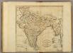
Map of Hindostan or India.
1 : 9500000 Carey, Mathew
Hindostan or India.
1 : 14572800 Carey, Mathew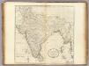
Map of Hindostan or India.
1 : 10264320 Carey, Mathew
Map of Hindostan or India.
1 : 10264320 Carey, Mathew
Vorder - Indien

[Vorder-Indien oder Ango-Indische Reich]
Hand-Atlas über alle Theile der Erde und über das Weltgebäude Stieler, Adolf Justus Perthes
Volker-Karte der Indischen Welt.
1 : 9400000 Berghaus, Heinrich
Sinus Gangeticus: Vulgo Golfo De Bengala Nova descriptio. [Karte], in: Novus atlas absolutissimus, Bd. 9, S. 115.
1 Karte aus Atlas Janssonius Offizin
Hindostan.
1 : 17200000 Bowen, Frances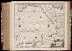
Sinus Gangeticus; vulgo Golfo de Bengala nova descriptio
1 : 4500000 Annotatie: Zeekaart; Kaart uitg. in de periode vanaf ca. 1650 tot ca. 1680; Origineel is Blad 190 in atlas factice; Annotatie geografische gegevens: Schaalstokken op de kaart: 45 Milliaria Germanica communia (=7,5 cm), en: 60 Milliaria Gallica communia (=7,5 cm); Westen boven Johannes Janssonius 1588-1664 [Amstelodami] : [Apud Ioannem Ianssonium]
India.
1 : 8400000 Sharpe, J.
Indien & Inner-Asien In 2 Blattern. (Sudliches Blatt)
1 : 7500000 Petermann, A.
Völker-Karte der Indischen Welt
Zweiter Band, enthaltend in vier Abtheilungen die Vertheilung der Organismen: 5. Pflanzen-Geographie, 6. Thier-Geographie, 7. Anthropographie, 8. Ethnographie Humboldt, Alexander von Verlag von Justus Perthes