Maps of Allegheny Plat.

Lord Balitmore's own plan : proposed Maryland/Pennsylvania boundary.
from Maryland
E. United States 7.
1 : 1774080 Letts, Son & Co.
County map of Pennsylvania, New Jersey, Maryland and Delaware ; City of Philadelphia [inset]; City of Baltimore [inset].
from Mitchell's new general atlas, containing maps of the various countries of the world, plans of cities, etc., embraced in fifty-three quarto maps., forming a series of eighty four maps and plans, together with valuable statistical tables.
Map of the Middle States.
1 : 3041280 Mitchell, Samuel Augustus
Eastern U.S.
1 : 2750000 Cornell, S. S. (Sarah S.)
Middle States.
1 : 2800000 Olney, J. (Jesse), 1798-1872
Novi Belgii novaeque Angliae nec non partis Virginiae tabula
1 : 2220000 Manhattan (New York, New York) Visscher, Nicolaus a Nicolao Joannis Vißchero
Middle States.
1 : 2800000 Huntington, Hezekiah, 1795-1865
Virginia, Maryland, and Delaware / by H.S. Tanner.
from Charts and maps
Penn., N.J., Md., Dela., D.C., Virginia.
1 : 1770000 Society for the Diffusion of Useful Knowledge (Great Britain)
Map of Virginia and Maryland, constructed from the latest authorities / J.H. Young sc.
from Parts
A map of that part of America where a degree of latitude was measured for the Royal Society / by Cha. Mason & Jere. Dixon.
from Charts and maps
The State of Virginia from the best authorities, 1796 / B. Tanner sculpt.
from Charts and maps
The tourist's pocket map of the state of Virginia : exhibiting its internal improvements, roads, distances, &c. / by J.H. Young ; engraved by E. Yeager & F. Dankworth.
from Virginia
The state of Virginia : from the best authorities / by Samuel Lewis, 1794 ; Smither, sculpt.
from Notes on the State of Virginia. By Thomas Jefferson.
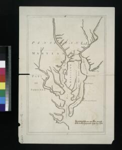
A New map of the province of Maryland in North America.
from Maryland
A new map of Virginia : from the best authorities / by T. Kitchen, geogr.
from Virginia
Operations in Virginia.
from Virginia
A map of the most inhabited part of Virginia containing the whole province of Maryland with part of Pensilvania, New Jersey and North Carolina / drawn by Joshua Fry & Peter Jefferson in 1775.
from Charts and maps
Map of Virginia, Maryland and Delaware exhibiting the post offices, post roads, canals, rail roads &c. / by David H. Burr, (Late topographer to the Post Office,) Geographer to the House of Representatives of the U.S.
from Parts David H. Burr,
(Virginia, Maryland, Delaware)
1 : 4200000 Moore, M. B. (Marinda Branson), 1829-1864
Our Nation's Camp Ground.
1 : 2181787 Ensign, Bridgman & Fanning
Virginia, Maryland, and Delaware / by H.S. Tanner.
from Parts
Virginia and Maryland / By H. Moll, geographer.
from Parts
Nova Virginiae Tabula [Karte], in: Novus atlas absolutissimus, Bd. 6, S. 207.
1 Karte aus Atlas Janssonius Offizin
A new map of New Jarsey and Pensilvania / by Robt. Morden.
from Atlas terrestris / by Robt. Morden.
D'Engelze volkplanting in Virginie / door Iohan Smith bezogt en verder uytgeset ; uytgevoerd te Leyden door Pieter vander Aa.
from De Gedenkwaardige Reizen vanden beroemden Capiteyn Johan Smith na Virginien : gedaan in den Jare 1606. en vervolgens ; waar in een nauwkeurige beschrijving dier Plaatsen, desselfs Inwoonders, hunne Godsdienst, Zeden, Gewoontens, manieren van Regeering, Planten, Vrugten, enz. omstandig vertoond werd, mitsgaders des Schrijvers wonderlijke gevallen met de Wilden, en verdere zeldzame ontmoetingen ; nu aldereerst uit het Engels vertaald, met nodige Konst-printen en Register voorzien.
A map of the province of Pensilvania / drawn from the best authorities, by T. Kitchin, gr.
from John H. Levine Collection
A new map of Virginia from the best authorities / by T. Kitchin, Geogr.
from London magazine, or, Gentleman's monthly intelligencer (1747)