Maps of Allegheny Plat.

E. United States 7.
1 : 1774080 Letts, Son & Co.
Lord Balitmore's own plan : proposed Maryland/Pennsylvania boundary.
from Maryland
Eastern U.S.
1 : 2750000 Cornell, S. S. (Sarah S.)
County map of Pennsylvania, New Jersey, Maryland and Delaware ; City of Philadelphia [inset]; City of Baltimore [inset].
from Mitchell's new general atlas, containing maps of the various countries of the world, plans of cities, etc., embraced in fifty-three quarto maps., forming a series of eighty four maps and plans, together with valuable statistical tables.
Middle States.
1 : 2800000 Olney, J. (Jesse), 1798-1872
Penn., N.J., Md., Dela., D.C., Virginia.
1 : 1770000 Society for the Diffusion of Useful Knowledge (Great Britain)
A New map of the province of Maryland in North America.
from Maryland
Virginia, Maryland, and Delaware / by H.S. Tanner.
from Charts and maps
Map of Virginia and Maryland, constructed from the latest authorities / J.H. Young sc.
from Parts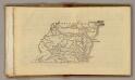
(Virginia, Maryland, Delaware)
1 : 4200000 Moore, M. B. (Marinda Branson), 1829-1864
Virginia and Maryland / By H. Moll, geographer.
from Parts
Our Nation's Camp Ground.
1 : 2181787 Ensign, Bridgman & Fanning
The tourist's pocket map of the state of Virginia : exhibiting its internal improvements, roads, distances, &c. / by J.H. Young ; engraved by E. Yeager & F. Dankworth.
from Virginia
Nova Virginiae Tabula [Karte], in: Novus atlas absolutissimus, Bd. 6, S. 207.
1 Karte aus Atlas Janssonius Offizin
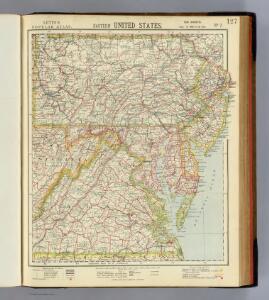
North America: sheet VII, Pennsylvania, New Jersey, Maryland, Delaware, Columbia and part of Virginia / published under the superintendence of the Society for the Diffusion of Useful Knowledge; J. & C. Walker, sculp.
from Parts C. Walker,
Middle States.
1 : 3600000 Huntington, Nathaniel G. (Nathaniel Gilbert), 1785-1848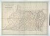
Map of Virginia, Maryland and Delaware exhibiting the post offices, post roads, canals, rail roads &c. / by David H. Burr, (Late topographer to the Post Office,) Geographer to the House of Representatives of the U.S.
from Parts David H. Burr,
A map of that part of America where a degree of latitude was measured for the Royal Society / by Cha. Mason & Jere. Dixon.
from Charts and maps
The tourist's pocket map of the state of Virginia: exhibiting its internal improvements, roads, distances, &c. / by J.H. Young; engraved by E. Yeager & F. Dankworth.
from Virginia J. H. Young; E. Yeager; F. Dankworth,
The tourist's pocket map of the state of Virginia: exhibiting its internal improvements, roads, distances, &c. / by J.H. Young; engraved by E. Yeager & F. Dankworth.
from Virginia J. H. Young; E. Yeager; F. Dankworth,
The travellers pocket map of Virginia: with its canals, rail-roads & distances from place to place along the stage roads / by H.S. Tanner; engraved by W. Brose, Philadelphia, 1830.
from Virginia Henry S. Tanner; W. Brose,
A new map of Virginia : from the best authorities / by T. Kitchen, geogr.
from Virginia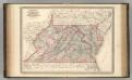
Virginia, Delaware, Maryland, and West Virginia.
1 : 1520000 Johnson, A.J.
Virginia, Delaware, Maryland, and West Virginia.
1 : 1520000 Johnson, A.J.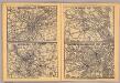
Philadelphia, Pittsburgh, Richmond, Baltimore-Washington.
Rand McNally and Company
A survey of the Northern Neck of Virginia : being the lands belonging to the Rt. Honourable Thomas Lord Fairfax Baron Cameron, bounded by & within the Bay of Chesapoyocke and between the rivers Rappahannock and Potowmack: With the courses of the rive
from Cartographic materials from the Emmet Collection of Manuscripts Etc. Relating to American History.
A map of the most inhabited part of Virginia containing the whole province of Maryland with part of Pensilvania, New Jersey and North Carolina / drawn by Joshua Fry & Peter Jefferson in 1775.
from Charts and maps
Operations in Virginia.
from Virginia
Virginia, Maryland, and Delaware / by H.S. Tanner.
from Parts