Maps of Piedmont

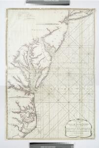
A new chart of the coast of North America : from New York to Cape Hatteras, including the bays of Delaware and Chesapeak, with the coasts of New Jersey, Maryland, Virginia and part of the coast of North Carolina / by Captain N. Holland.
from Parts
A chart of the coast of New York, New Jersey, Pensilvania, Maryland, Virginia, North Carolina, & c.
from Charts and maps
D'Engelze volkplanting in Virginie / door Iohan Smith bezogt en verder uytgeset = Peuplade des Anglois dans la Virginie / visitée et augmentée par Jean Smith, suivant qu il l'a décrite lui-même dans son voyage ; rectifiée sur de nouvelles observations fa
from Virginia
Il Maryland, il Jersey Meridionale, la Delaware e la parte orientale della Virginia, e Carolina Settentrionale.
from Le colonie unite dell' America settentrle : di nuova projezione a s.s.e.e. li Signori Riformatori dello Studio di Padova.
The state of Virginia : from the best authorities / by Samuel Lewis, 1809 ; Smither, sculpt.
from Carey's American atlas.
Virginia, Maryland, and Delaware / J. Knight sc.
from View of the United States, historical, geographical, and statistical, exhibiting, in a convenient form, the natural and artificial features of the several states, and embracing those leading branches of history and statistics best adapted to develop the present condition of the North American union ... By William Darby.
[Map of Virginia, North Carolina, and South Carolina].
from Aussführlich, und umständlicher Bericht von der berühmten Landschafft Carolina : in dem engelländischen America gelegen / an Tag gegeben von Kocherthalern.
A map of the country between Albemarle Sound and Lake Erie : comprehending the whole of Virginia, Maryland, Delaware and Pennsylvania, with parts of several other of the United States of America / engraved by S. J. Neele, No. 352 Strand, London.
from Notes on the state of Virginia; written in the year 1781, somewhat corrected and enlarged in the winter of 1782, for the use of a foreigner of distinction, in answer to certain queries proposed by him ...
Pas caerte van Nieu Nederlandt en de Engelsche Virginies van Cabo Cod tot Cabo Canrick.
from De zee-atlas, ofte, Water-weereld : waer in vertoont werden alle de zee-kusten van het bekende des aerd-bodems : seer dienstigh voor alle heeren en kooplieden, als oock voor alle schippers en stuurlieden / gesneden, gedruckt en uytgegeven t'Amsteldam.
A new map of the most considerable plantations of the English in America / Sutton Nicholls, sculp.
from Parts Sutton Nicholls,
The State of Virginia from the best authorities, 1796 / B. Tanner sculpt.
from Charts and maps
Virginia / S. Lewis, del.
from Virginia
A map of those parts of Virginia, North Carolina, South Carolina & Georgia which were the scenes of the most important operations of the southern armies
from Parts
A correct map of Virginia.
from Carey's general atlas, improved and enlarged : being a collection of maps of the world and quarters, their principal empires, kingdoms, &c.
Soil Map of the United States, Section 8. Atlas of American Agriculture.
1 : 2500000 Marbut, Curtis F.
A chart of the sea coasts of New-England, New-Jarsey, Virginia, Maryland and Carolina : from C. Cod to C. Hatteras / by John Seller, hydrogr. to the King ; Iames Clerk sculpsit.
from Atlas terrestris, or, A book of mapps of all the empires, monarchies, kingdomes, regions, dominions, principalities, and countreys in the whole world : accomodated with a brief description of the nature and quality of each particular countrey / by Iohn Seller, hydrographer to the Kings most excellent majestie.
Middle States.
1 : 3050000 Smiley, Thomas T.
The marches of Lord Cornwallis in the Southern Provinces : now States of North America, comprehending the two Carolinas, with Virginia and Maryland, and the Delaware counties / by William Faden, geographer to the King.
from Charts and maps
Map no. I : [to accompany A bill in the chancery of New Jersey, at the suit of John, Earl of Stair ... against Benjamin Bond].
from A bill in the chancery of New-Jersey, at the suit of John earl of Stair, and others, proprietors of the eastern-division of New-Jersey; against Benjamin Bond. and some other persons of Elizabeth-Town, distinguished by the name of the Clinker lot right men. With three large maps, done from copper-plates. To which is added; the publications of the Council of proprietors of East New-Jersey, and Mr. Nevill's speeches to the General assembly, concerning the riots committed in New-Jersey, and the pretences of the rioters, and their seducers. These papers will give a better light into the history and constitution of New-Jersey, than any thing hitherto published, the matters whereof have been chiefly collected from records. Published by subscription: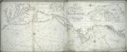
A new chart of America with the harbors of New York, Boston, &c / drawn from the latest authorities by W. Heather, 1799 ; Stephenson sculp.
from Charts and maps
Novi Belgii Novaeque Angliae nec non partis Virginiae tabula / multis in locis emendata per Nicolaum Visscher.
from John H. Levine Collection
Virginia, Maryland, and Delaware / by H.S. Tanner.
from Charts and maps
Virginia.
from Supplement to the New York observer.
County map of Virginia and West Virginia.
from New general atlas.
The tourist's pocket map of the state of Virginia : exhibiting its internal improvements, roads, distances, &c. / by J.H. Young ; engraved by E. Yeager & F. Dankworth.
from Virginia
County Map Of Virginia, and North Carolina.
1 : 2800000 Mitchell, Samuel Augustus
Il Maryland, il Jersey Meridionale, la Delaware.
1 : 2100000 Zatta, Antonio
A new map of Virginia from the best authorities / by T. Kitchin, Geogr.
from London magazine, or, Gentleman's monthly intelligencer (1747)
Virginia, Maryland, and Delaware / by H.S. Tanner.
from Parts