Maps of New York

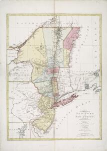
A map of the provinces of New-York and New Jersey : with a part of Pennsylvania and the Province of Quebec / from the topographical observations of C. J. Sauthier ; engraved and published by Matthew Albert Lotter.
from Charts and maps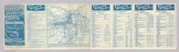
Rome, Watertown & Ogdensburg Railroad.
1 : 4308480 Rome, Watertown & Ogdensburg Railroad Company
Novi Belgii Novaeqve Angliae nec non partis Virginiae Tabula

A map of the provinces of New-York and New Jersey : with a part of Pennsylvania and the Province of Quebec / from the topographical observations of C. J. Sauthier ; engraved and published by Matthew Albert Lotter.
from Parts
Recens edita totius Novi Belgii, in America Septentrionali siti

Map Montreal and Boston Air Line.
1 : 2223700 Montreal and Boston Air Line
Recens edita totius Novi Belgii in America Septentrionali siti / delineatio cura et sumtibus Tob. Conr. Lotteri, Sac. Caes. Maj. Geographi August. Vind.
from John H. Levine Collection Conrad Lotter,

Novi Belgii Novaeque Angliae nec non partis Virginiae tabula / multis in locis emendata a Nicolao Joannis Visschero
1 : 2500000 Annotatie: Lit.: The map collectors' circle, no. 24 (1965); Oorspr. uitg.: [Amsterdam : N.J. Visscher, ca. 1655] Visscher, Claes Jansz. [Amsterdam : nunc apud Petr. Schenk Iun.]
New York / drawn by S. Lewis ; Tanner, sc.
from Whole

Mappa geographica provinciae novae eboraci ab anglis New-York
1 : 10000 New Jersey Sauthier, Claudii Josephi Homannianor Heredum
A map of New England and New York

Carte du theatre de la guerre entre les Anglais et les Américains; dressée d'aprés les cartes anglaises les plus modernes / par M. Brion de la Tour, ingénieur-géographe du roi.
from Revolutionary War, 1775-1783 M. Bellin,
Lloyd's Railroad, Telegraph & Express Map of the Eastern States
Lloyd's Railroad, Telegraph & Express Map of the Eastern States to accompany Lloyd's Railroad, Telegraph & Express Map of the United States and Canadas. This map shows the communication lines of the eastern states of the Union as they existed in 1863. Reliable communication networks were vital during the war to send troops and messages from one theatre of conflict to another. The map also lists the position of telegraph stations close to the offices of Express companies which provided the main form of travel in this period of American history.
Railroad Map Of The Eastern & Middle States.
1 : 380160 Rand McNally and Company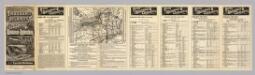
Rome, Watertown and Ogdensburg Railroad.
1 : 5514850 Rome, Watertown & Ogdensburg Railroad Company
Nova Belgica Et Anglia Nova [Karte], in: Le théâtre du monde, ou, Nouvel atlas contenant les chartes et descriptions de tous les païs de la terre, Bd. 2, S. 303.
1 Karte aus Atlas Blaeu, Willem Janszoon und Blaeu, Joan Blaeu, Willem Janszoon
Map of the interior travels through America, delineating the march of the army

Carte du théatre de la guerre entre les Anglais et les Américains

Carte du théatre de la guerre entre les Angais et les Américans

A map of the provinces of New-York and New-Jersey, with a part of Pennsylvania and the province of Quebec
1 : 1025000 New Jersey Lotter, Matthäus Albrecht Matthew Albert Lotter
Railway map of routes to the White Mountains
Boardman, Harvey J.H. Bufford's Lith.
Nova Belgica Et Anglia Nova [Karte], in: Novus Atlas, das ist, Weltbeschreibung, Bd. 2, S. 306.
1 Karte aus Atlas Blaeu, Joan Blaeu, Willem Janszoon
Map of the New York Central & Hudson River and Boston & Albany Railroads

Map Central Vt. RR.
1 : 3509000 Central Vermont Railroad Company
Carte du théatre de la guerre entre les Anglais et les Américains dressée d'après les cartes anglaises les plus modernes, / par M. Brion de la Tour, ingr. géographe du Roi.
from Charts and maps M. Bellin,
Carte du théatre de la guerre entre les Anglais et les Américains: dressée d'après les cartes anglaises les plus modernes / par M. Brion de la Tour, ingénieur-geógraphe du Roi.
from Charts and maps M. Bellin,
Mappa geographica Provinciae Novae Eboraci ab Anglis New-York dictae / ex ampliori delineatione ad exactas dimensiones concinnata in arctius spatium redacta cura Claudii Josephi Sauthier cui accedit Nova Jersey ex topographicis observationibus.
from Charts and maps Claude Joseph Sauthier,