Maps of Massachusetts

Carte du théatre de la guerre entre les Anglais et les Américains

Carte du théatre de la guerre entre les Angais et les Américans

Map Central Vt. RR.
1 : 3509000 Central Vermont Railroad Company
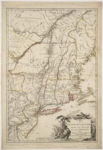
Carte du théatre de la guerre entre les Anglais et les Américains dressée d'après les cartes anglaises les plus modernes, / par M. Brion de la Tour, ingr. géographe du Roi.
from Charts and maps M. Bellin,
Carte du théatre de la guerre entre les Anglais et les Américains: dressée d'après les cartes anglaises les plus modernes / par M. Brion de la Tour, ingénieur-geógraphe du Roi.
from Charts and maps M. Bellin,
Carte du theatre de la guerre entre les Anglais et les Américains; dressée d'aprés les cartes anglaises les plus modernes / par M. Brion de la Tour, ingénieur-géographe du roi.
from Revolutionary War, 1775-1783 M. Bellin,
A map of the provinces of New-York and New Jersey : with a part of Pennsylvania and the Province of Quebec / from the topographical observations of C. J. Sauthier ; engraved and published by Matthew Albert Lotter.
from Charts and maps
Recens edita totius Novi Belgii in America Septentrionali siti / delineatio cura et sumtibus Tob. Conr. Lotteri, Sac. Caes. Maj. Geographi August. Vind.
from John H. Levine Collection Conrad Lotter,
Novi Belgii Novaeqve Angliae nec non partis Virginiae Tabula

Carte du théatre de la guerre entre les Anglais et les Américains
1 : 1400000 Nová Anglie Brion de la Tour, Louis Esnauts et Rapilly
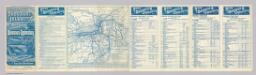
Lloyd's Railroad, Telegraph & Express Map of the Eastern States
Lloyd's Railroad, Telegraph & Express Map of the Eastern States to accompany Lloyd's Railroad, Telegraph & Express Map of the United States and Canadas. This map shows the communication lines of the eastern states of the Union as they existed in 1863. Reliable communication networks were vital during the war to send troops and messages from one theatre of conflict to another. The map also lists the position of telegraph stations close to the offices of Express companies which provided the main form of travel in this period of American history.
A map of the provinces of New-York and New Jersey : with a part of Pennsylvania and the Province of Quebec / from the topographical observations of C. J. Sauthier ; engraved and published by Matthew Albert Lotter.
from Parts
Nova Anglia Septentrionali Americae implantata Anglorumque coloniis florentissima geographicè exhibita
Rome, Watertown & Ogdensburg Railroad.
1 : 4308480 Rome, Watertown & Ogdensburg Railroad Company
Scene of Operations of the Northern Army.
1 : 1950000 Marshall, John
Railway map of the New England states : prepared expressly for the Pathfinder railway guide
Snow, George K., 1826 or 7-1885 Geo. K. Snow ; Rand, Avery, & Co.
A map of New England and New York

New England.
from A new systeme of the mathematicks: containing I. Arithmetick, as well natural and decimal, as in species, or the principles of algebra. II. Practical geometry, together with the first six books of Euclid's Elements, as also the eleventh and twelfth, symbo
Mappa geographica Provinciae Novae Eboraci ab Anglis New-York dictae / ex ampliori delineatione ad exactas dimensiones concinnata in arctius spatium redacta cura Claudii Josephi Sauthier cui accedit Nova Jersey ex topographicis observationibus.
from Charts and maps Claude Joseph Sauthier,
Map Montreal and Boston Air Line.
1 : 2223700 Montreal and Boston Air Line
Rome, Watertown and Ogdensburg Railroad.
1 : 5514850 Rome, Watertown & Ogdensburg Railroad Company
N.Y., Vt., Maine, N.H., Mass., Conn., R.I., N.J.
1 : 1770000 Society for the Diffusion of Useful Knowledge (Great Britain)
Map of the New York Central & Hudson River and Boston & Albany Railroads

Railroad map of New England & eastern New York : compiled from the most authentic sources
1 : 700000 Goldthwait, J. H Redding & Co. ; Clark, Austin & Co.
Map of the Sherbrooke, Eastern Townships and Kennebec Railway : with connections
1 : 1267200 G.W. & C.B. Colton & Co G.W. & C.B. Colton & Co.
Nova Anglia Septentrionali Americae implantata Anglorumque coloniis florentissima / geographice exhibita â Ioh. Baptista Homann, sac. caes. maj. geographo.
from John H. Levine Collection John Baptista Homann, S.,
Mappa geographica provinciae novae eboraci ab anglis New-York
1 : 10000 New Jersey Sauthier, Claudii Josephi Homannianor Heredum
Nova Belgica Et Anglia Nova [Karte], in: Theatrum orbis terrarum, sive, Atlas novus, Bd. 2, S. 319.
1 Karte aus Atlas Blaeu, Joan Blaeu, Willem Janszoon
Carte de la Nouvelle Angleterre: New York, Pensilvanie et Nouveau Jersay suivant les cartes angloises.
from John H. Levine Collection Bellin: [Paris]; Bellin, Jacques Nicolas,