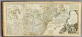
Maps of Appalachian Mountains

A new map of North America from the latest discoveries, 1763.
from Charts and maps s.n.: [London],
A new and accurate map of the English empire in North America: representing their rightful claim as confirm'd by charters and the formal surrender of their Indian friends, likewise the encroachments of the French, with the several forts they have unjustly erected therein / by a Society of Anti-Gallicans.
from Charts and maps Society of Anti-Gallicans.,
A new and correct map of North America: in which the places of the principal engagements during the present war are accurately inserted / Jno. Lodge sculpt.
from Parts John Lodge,
A Map of the British and French settlements in North America.
from Parts J. (John) Hinton, Newgate Street: [London],
Carte des Possessions Angloises & Françoises du Continent de l'Amerique Septentrionale
1 : 6900000 Mollova mapová sbírka Gosse, Pierre
AMERICA SEPTENTRIONALIS
1 : 6300000 Ohio, řeka-oblast Anville, Jean-Baptiste Bourguinon d' sumptibus ab Homannianorum Heredum
America Septentrionalis
1 : 6500000 Spojené státy americké-oblast východní Anville, Jean-Baptiste Bourguinon d' ab Homanniorum Heredum
AMERICA SEPTENTRIONALIS
1 : 7000000 Ohio, řeka-oblast Anville, Jean-Baptiste Bourguinon d' sumptibus ab Homannianorum Heredum
America Septentrionalis a Domino d'Anville in Galliis edita nunc in Anglia: Coloniis in interiorem Virginiam deductis nec non Fluvii Ohio cursu aucta notisque geographicis et historicis illustrata / Sumptibus Homannianorum Heredum.
from Charts and maps Sumptibus Homannianorum Heredum,
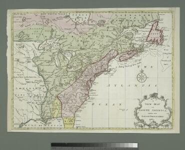
The United States of America with the British possessions of Canada, Nova Scotia, & of Newfoundland, divided with the French ...

North America.
1 : 6500000 Jefferys, Thomas
A New & accurate map of North America: including the British acquisitions gain'd by the late war, 1763.
from Parts [Printed fr Edward and Charles Dilly, in the Poultry, and John Millan, at Charing-Cross]: [London],
Canada et Louisiane
Kanada Le Rouge, Georges-Louis le Rouge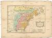
Carte des possessions angloises & françoises du continent de l'Amérique septentrionale
1 : 8500000 Severní Amerika Gosse, Pierre
A new map of North America from the latest discoveries / J. Spilsbury, sculp.
from Parts J. Spilsbury,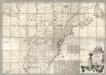
Map of the British and French Dominions in North America.
1 : 2000000 Mitchell, John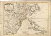
Carte des possessions angloises dans l'Amerique Septentrionale
1 : 3500000 Spojené státy americké-oblast východní Imbert, J. Leopold chez Mondhare
Carte generale des treize Etats Unis, de l'Amerique septentrionale

America Septentrionalis
1 : 1300000 Kanada západní Anville, Jean-Baptiste Bourguinon d' Homannianorum heredum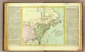
Possessions Francoises.
1 : 12500000 Clouet, J. B. L. (Jean-Baptiste Louis), b. 1730
Composite: Canada, Louisiane, Terres Angloises.
1 : 2900000 Anville, Jean Baptiste Bourguignon d, 1697-1782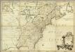
Amerique Septentrionale.
1 : 2000000 Mitchell, John
Canada et Louisiane / par le Sr. le Rouge ingénieur géographe du Roy.
from Charts and maps
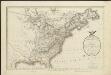
The United States of North America, with the British & Spanish territories according to the Treaty of 1784 / engrav'd by Wm. Faden, 1785.
from Charts and maps William Faden,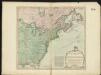
The United States of America with the British possessions of Canada, Nova Scotia, New Brunswick and Newfoundland divided with the French, also the Spanish territories of Louisiana and Florida according to the preliminary articles of peace signed at Versailles the 20th of Jany. 1783
A map of the United States and Canada, New-Scotland, New-Brunswick and New-Foundland = Carte des Etats-Unis, avec le Canada, la Nouvelle Ecosse, le Nouveau Brunswick & Terre-Neuve
1 : 6500000 dressée par Lapie gravé par P. A. F. Tardieu ; écrit par J. J. Pachoux Paris [etc.] : P.A.F. Tardieu [etc.]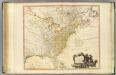
United States of North America.
1 : 6350000 Faden, William, 1750?-1836
A new map of the English empire in America: viz. Virginia, Maryland, Carolina, New York, New Iarsey, New England, Pennsylvania, Newfoundland, New France &c. / revis'd by Ion. Senex, 1719; I. Harris, sculp.
from John H. Levine Collection John Senex; I. Harris,
A new map of the English empire in America: viz. Virginia, Maryland, Carolina, New York, New Iarsey, New England, Pennsylvania, Newfoundland, New France &c. / revis'd by Ion. Senex, 1719; I. Harris, sculp.
from Charts and maps John Senex; I. Harris,