Maps of Appalachian Mountains

A new map of the English empire in America: viz. Virginia, Maryland, Carolina, New York, New Iarsey, New England, Pennsylvania, Newfoundland, New France &c. / revis'd by Ion. Senex, 1719; I. Harris, sculp.
from John H. Levine Collection John Senex; I. Harris,
A new map of the English empire in America: viz. Virginia, Maryland, Carolina, New York, New Iarsey, New England, Pennsylvania, Newfoundland, New France &c. / revis'd by Ion. Senex, 1719; I. Harris, sculp.
from Charts and maps John Senex; I. Harris,
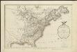
The United States of North America, with the British & Spanish territories according to the Treaty of 1784 / engrav'd by Wm. Faden, 1785.
from Charts and maps William Faden,
Carte de l'Amérique septentrionale, depuis la baye d'Hudson jusqu'au Mississipi: pour servir aux essais historiques et politiques sur la révolution de cette partie du monde.; Essais historiques et politiques sur les Anglo-Américains, par M. Hilliard d'Auberteuil ...
from Essais historiques et politiques sur les Anglo-Américains, par M. Hilliard d'Auberteuil ... Hilliard d'Auberteuil, Michel René,
Canada et Louisiane / par le Sr. le Rouge ingénieur géographe du Roy.
from Charts and maps
United States
A new general atlas of modern geography, consisting of a complete collection of maps of the four quarters of the globe Wyld, James James Wyld
Possessions Francoises.
1 : 12500000 Clouet, J. B. L. (Jean-Baptiste Louis), b. 1730
United States of North America.
1 : 6350000 Faden, William, 1750?-1836
America Septentrionalis
1 : 1300000 Kanada západní Anville, Jean-Baptiste Bourguinon d' Homannianorum heredum
America Septentrionalis a Domino d'Anville in Galliis edita nunc in Anglia: Coloniis in interiorem Virginiam deductis nec non Fluvii Ohio cursu aucta notisque geographicis et historicis illustrata / Sumptibus Homannianorum Heredum.
from Charts and maps Sumptibus Homannianorum Heredum,
The United States of America, showing the boundaries fixed in 1782, five years before the ratification of the Constitution : from a contemporary copy of Benjamin Franklin's red-line map identified in Spain by the Library of Congress at Washington.
1 : 6860480 Facsimile of map published in Paris by Le Rouge and dated 1777. Relief shown pictorially. Inset letters of Aranda and Franklin printed in facsimile reflect the official use of the map in establishing United States boundaries. "Reprinted 1838 by U.S. Geological Survey." Includes text and inset: Nouvelle carte de la Baye dHudson et de Labrador selon las dernieres cartes levées sur les lieux. "This map is one of a series of similar colored maps, depicting the 13 original states from New Hampshire to Georgia at the time of the formation of the Constitution." John, Mitchel, 1711-1768 Washington, D.C. : United States Constitution Sesquicentennial Commission, [Washington, D.C.] : U.S. Geological Survey
Composite: Canada, Louisiane, Terres Angloises.
1 : 2900000 Anville, Jean Baptiste Bourguignon d, 1697-1782
A new map of the British colonies in North America : shewing the seat of the present war, taken from the best surveys, compared with and improved from manuscripts of several noblemen and gentlemen / by John Andrews.
from Charts and maps
A new map of North America from the latest discoveries / J. Spilsbury, sculp.
from Parts J. Spilsbury,
Canada et Louisiane
Kanada Le Rouge, Georges-Louis le Rouge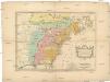
Carte des possessions angloises & françoises du continent de l'Amérique septentrionale
1 : 8500000 Severní Amerika Gosse, Pierre
Carte des Possessions Angloises & Françoises du Continent de l'Amerique Septentrionale
1 : 6900000 Mollova mapová sbírka Gosse, Pierre
AMERICA SEPTENTRIONALIS
1 : 6300000 Ohio, řeka-oblast Anville, Jean-Baptiste Bourguinon d' sumptibus ab Homannianorum Heredum
America Septentrionalis
1 : 6500000 Spojené státy americké-oblast východní Anville, Jean-Baptiste Bourguinon d' ab Homanniorum Heredum
AMERICA SEPTENTRIONALIS
1 : 7000000 Ohio, řeka-oblast Anville, Jean-Baptiste Bourguinon d' sumptibus ab Homannianorum Heredum
A new map of North America from the latest discoveries, 1763.
from Charts and maps s.n.: [London],
The United States of North America, with the British & Spanish territories according to the treaty / engrav'd by Wm. Faden.
from Whole William Faden,
Ètats-Unis de l'Amérique septentrionale avec les Isles Royale, de Terre Neuve, de St. Jean, l'Acadie &c.
from Charts and maps Chez Delamarche, géogr.: Paris; Delamarche, Charles François,
Ètats-Unis de l'Amérique septentrionale avec les Isles Royale, de Terre Neuve, de St. Jean, l'Acadie &c.
from John H. Levine Collection Chez Delamarche, géogr.: Paris; Delamarche, Charles François,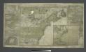
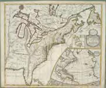
A new and accurate map of the English empire in North America: representing their rightful claim as confirm'd by charters and the formal surrender of their Indian friends, likewise the encroachments of the French, with the several forts they have unjustly erected therein / by a Society of Anti-Gallicans.
from Charts and maps Society of Anti-Gallicans.,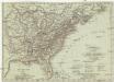
Vereinigte Staaten in Nord America
1 : 10000000 Spojené státy americké-oblast jihovýchodní T. Mollo
Vereinigte Staaten in Nord America: nach den besten Hülfsmittel verfast / Wien bey T. Mollo.; Lorenz Rieder sc.
from Charts and maps Wien bey; T. Mollo. Lorenz Rieder,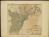
The United States of America with the British possessions of Canada, Nova Scotia, & of Newfoundland, divided with the French ...

North America from the French of Mr. D'Anville: improved with the back settlements of Virginia and course of Ohio: illustrated with geographical and historical remarks.
from Charts and maps D'Anville,