Maps of Secaucus

Jersey City, V. 1, Double Page Plate No. 32 [Map bounded by Secaucus Rd., Nelson Ave., Thorne St., Pen Horn Creek] / compiled under the direction of and published by G.M. Hopkins Co.
From V. 1
Jersey City, V. 1, Double Page Plate No. 12 [Map bounded by Paterson Plank Rd., Jackson St., South St., Nelson Ave., Secaucus Rd.] / compiled under the direction of and published by G.M. Hopkins Co.
From V. 1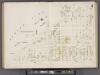
Hudson County, V. 8, Double Page Plate No. 2 [Map bounded by Summit Ave., Courtland St., Spring St., Paterson Plank Rd.] / surveyed and published by Chas. B. Brush. Vol. 8.
From Insurance maps of Hudson County, New Jersey
Topographical atlas of the City of New York / by Egbert L. Viele.
from Topographical atlas of the city of New York, / including the annexed territory showing original water courses and made land / prepared under the direction of Egbert L. Viele.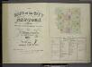
[Volume 7 Index Map.]
from Maps of the city of New York / surveyed under directions of insurance companies of said city.
Jersey City, V. 1, Double Page Plate No. 31 [Map bounded by Thorne St., Hudson Blvd., Hackensack River, Pen Horn Creek] / compiled under the direction of and published by G.M. Hopkins Co.
From V. 1
8C - N.Y. City (Aerial Set).
from Sectional aerial maps of the City of New York / [photographed and assembled under the direction of the chief engineer, July 1st, 1924].
8A - N.Y. City (Aerial Set).
from Sectional aerial maps of the City of New York / [photographed and assembled under the direction of the chief engineer, July 1st, 1924].
Jersey City, V. 1, Double Page Plate No. 11 [Map bounded by South St., Marshall St., Franklin St., Manhattan Ave., Hudson Blvd.] / compiled under the direction of and published by G.M. Hopkins Co.
From V. 1
Hudson County, V. 8, Double Page Plate No. 3 [Map bounded by Kerrigan Ave., Charles St., Courtland St., Bergen Wood] / surveyed and published by Chas. B. Brush. Vol. 8.
From Insurance maps of Hudson County, New Jersey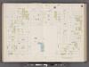
Hudson County, V. 8, Double Page Plate No. 5 [Map bounded by Kerrigan Ave., Oak St., West St., Charles St.] / surveyed and published by Chas. B. Brush. Vol. 8.
From Insurance maps of Hudson County, New Jersey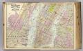
1 New York, Brooklyn, Jersey City.
1 : 18300 Watson, Gaylord
Hoboken, Jersey City.
1 : 19200 Beers, F. W. (Frederick W.)
Greenwich Village, West Village, Little Italy. (cont.)
From District 2
Dutch Era Land Grants in Stokes Iconography sheet with Greenwich Village & Lower Manhattan.
from Manhattan
Map of New York, Brooklyn, Jersey City& c.
from Atlas of the Hudson River Valley from New York city to Troy, including a section of about 8 miles in width. Published by Watson & co. Compiled from official records and careful surveys, under the supervision of F. W. Beers.
Map of the City of New York with the adjacent cities of Brooklyn & Jersey City, & the village of Williamsburg.
From Manhattan
Amap of the city and county of New York, with the adjacent cities of Brooklyn and Jersey City, and the village of Williamsburg: with a street directory of the city of New York.
From Manhattan
New York City south of 93rd Street.
From Manhattan
Map Of New York and Vicinity.
1 : 23000 Dripps, Matthew
Facsimile of the unpublished British head quarters coloured manuscript map of New York & environs / reproduced from the original drawing in the War Office, London.
from Whole
Citizens and Travelers' Guide map in, to, and from the City of New York and adjacent places.
From Manhattan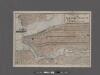
Elevated railway map of New York, Brooklyn, and Jersey City.
From Manhattan
Taunton's pocket edition of the merchant's and shipper's guide map to the port of New York / S.D.L. Taunton.
from Whole
Colton's new map of the city and county of New York [North and South of 93rd St.] including the extension north of the Harlem River.
From Manhattan
Map of the cities of New York, Jersey City, Hoboken, with part of Brooklyn.
From Manhattan
New York City
from Manhattan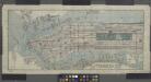
Title on face of map: Albemarle Hotel map of Manhattan, City of New York
from Manhattan
Outline and Index Map of Atlas of New York City : Manhattan Island.
from Atlas of the city of New York, Manhattan Island. From actual surveys and official plans / by George W. and Walter S. Bromley.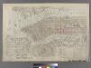
![Jersey City, V. 1, Double Page Plate No. 32 [Map bounded by Secaucus Rd., Nelson Ave., Thorne St., Pen Horn Creek] / compiled under the direction of and published by G.M. Hopkins Co.](https://images-0.georeferencer.com/images/iiif/364314656970/full/,300/0/native.jpg)

