Maps of Jersey City
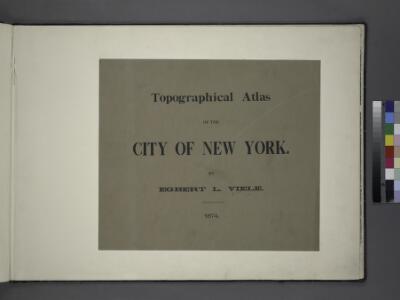
Topographical atlas of the City of New York / by Egbert L. Viele.
from Topographical atlas of the city of New York, / including the annexed territory showing original water courses and made land / prepared under the direction of Egbert L. Viele.
Jersey City, V. 1, Double Page Plate No. 29 [Map bounded by Dungan Ave., Olean Ave., West Side Ave., Boyed Ave., Hacken Sack River] / compiled under the direction of and published by G.M. Hopkins Co.
From V. 1
Jersey City, V. 1, Double Page Plate No. 30 [Map bounded by Newark Ave., West Side Ave., Duncan Ave., Hackensack River] / compiled under the direction of and published by G.M. Hopkins Co.
From V. 1
Jersey City, V. 1, Double Page Plate No. 28 [Map bounded by Hackensack River, Boyd Ave., West Side Ave., Newark Bay] / compiled under the direction of and published by G.M. Hopkins Co.
From V. 1
Jersey City, V. 1, Double Page Plate No. 31 [Map bounded by Thorne St., Hudson Blvd., Hackensack River, Pen Horn Creek] / compiled under the direction of and published by G.M. Hopkins Co.
From V. 1
Jersey City, V. 1, Double Page Plate No. 19 [Map bounded by Ocean Ave., Bramhall Ave., Bay View Ave.] / compiled under the direction of and published by G.M. Hopkins Co.
From V. 1
Jersey City, V. 1, Double Page Plate No. 18 [Map bounded by Van Horne St., Grand St., Monmouth St., Jersey Ave., Phillip St.] / compiled under the direction of and published by G.M. Hopkins Co.
From V. 1
Jersey City, V. 1, Double Page Plate No. 21 [Map bounded by Orient Ave., Ocean Ave., Woodlawn Ave., West Side Ave.] / compiled under the direction of and published by G.M. Hopkins Co.
From V. 1
Jersey City, V. 1, Double Page Plate No. 17 [Map bounded by Madison Ave., Summit Ave., Balowin Ave., Montgomery St., Bright St., Van Horne St., Bramhall Ave.] / compiled under the direction of and published by G.M. Hopkins Co.
From V. 1
Jersey City, V. 1, Double Page Plate No. 20 [Map bounded by Communipaw Ave., Madison Ave., Clerk St., Orient Ave., West Side Ave.] / compiled under the direction of and published by G.M. Hopkins Co.
From V. 1
Jersey City, V. 1, Double Page Plate No. 13 [Map bounded by Liberty Ave., Manhattan Ave., Oakland Ave., Newark Ave.] / compiled under the direction of and published by G.M. Hopkins Co.
From V. 1
Jersey City, V. 1, Double Page Plate No. 15 [Map bounded by West Side Ave., Newark Ave., Summit Ave., Montgomery St.] / compiled under the direction of and published by G.M. Hopkins Co.
From V. 1
Jersey City, V. 1, Double Page Plate No. 16 [Map bounded by Montgomery St., Summit Ave., Crescent Ave., Communipaw Ave., Olean Ave.] / compiled under the direction of and published by G.M. Hopkins Co.
From V. 1
Jersey City, V. 1, Double Page Plate No. 22 [Map bounded by Woodlawn Ave., Ocean Ave., Greenville Ave., Newark Bay, West Side Ave.] / compiled under the direction of and published by G.M. Hopkins Co.
From V. 1
Jersey City, V. 1, Double Page Plate No. 32 [Map bounded by Secaucus Rd., Nelson Ave., Thorne St., Pen Horn Creek] / compiled under the direction of and published by G.M. Hopkins Co.
From V. 1
Jersey City, V. 1, Double Page Plate No. 25 [Map bounded by Ocean Ave., bay view Ave., New York Bay, Linden Ave.] / compiled under the direction of and published by G.M. Hopkins Co.
From V. 1
Jersey City, V. 1, Double Page Plate No. 9 [Map bounded by Summit Ave., Washburn St., Division St., Bright St.] / compiled under the direction of and published by G.M. Hopkins Co.
From V. 1
Jersey City - Plate I.
Hopkins, G.M.
Jersey City, V. 1, Double Page Plate No. 8 [Map bounded by Prior St., 3rd St., Monmouth St., Grand St.] / compiled under the direction of and published by G.M. Hopkins Co.
From V. 1
Jersey City, V. 1, Double Page Plate No. 4 [Map bounded by Division St., 12th St., Jersey Ave., 2nd St.] / compiled under the direction of and published by G.M. Hopkins Co.
From V. 1
Jersey City, V. 1, Double Page Plate No. 10 [Map bounded by Central Ave., Franklin St., Jersey Ave., 12th St., Washborn St., Oakland Ave.] / compiled under the direction of and published by G.M. Hopkins Co.
From V. 1
Jersey City, V. 1, Double Page Plate No. 2 [Map bounded by Monmouth St., 2nd St., Erie St., Grove St., Morris Canal] / compiled under the direction of and published by G.M. Hopkins Co.
From V. 1
Jersey City, V. 1, Double Page Plate No. 11 [Map bounded by South St., Marshall St., Franklin St., Manhattan Ave., Hudson Blvd.] / compiled under the direction of and published by G.M. Hopkins Co.
From V. 1
Jersey City, V. 1, Double Page Plate No. 12 [Map bounded by Paterson Plank Rd., Jackson St., South St., Nelson Ave., Secaucus Rd.] / compiled under the direction of and published by G.M. Hopkins Co.
From V. 1
Hudson County, V. 8, Double Page Plate No. 2 [Map bounded by Summit Ave., Courtland St., Spring St., Paterson Plank Rd.] / surveyed and published by Chas. B. Brush. Vol. 8.
From Insurance maps of Hudson County, New Jersey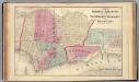
Hoboken, Jersey City.
1 : 19200 Beers, F. W. (Frederick W.)
Jersey City
1 : 24000
Jersey City
1 : 24000
Jersey City
1 : 24000
Jersey City
1 : 24000