Maps of Appalachian Mountains

Map of the United States of North America / compiled from the latest and most authentic information by David H. Vance ; engraved by J.H. Young.
From Whole
Partie de l'Amérique septentrionale, qui comprend le cours de l'Ohio, la Nlle. Angleterre, la Nlle York, le New Jersey, la Pensylvanie, le Maryland, la Virginie, la Caroline / par le Sr. Robert de Vaugondy, géographe ordinaire du roi ; M. C. Haussard, fe
from Charts and maps
Carte du theatre de la guerre presente en Amerique dressée d'après les nouvelles cartes anglaises / par L. Denis, géographe et auteur du conducteur français.
from Charts and maps L. Denis,
Carte du theatre de la guerre présente en Amerique
1 : 5000000 Nová Anglie Denis, L. Basset, André Basset
Carte nouvelle de l'Amerique angloise contenant tout ce que les Anglois possedent sur le continent de l'Amerique septentrionale savoir le Canada, la Nouvelle Ecosse ou Acadie, les treize Provinces unies qui sont: 1. New Hampshire, 2. Massachusetsbaye, 3. Rhode-Island, & 4. Conecticut, 5. la Nouvelle York, 6. Nouvelle Jersey, 7. Pensilvanie, 8. les Comtés de Newcastle, Kent et Sussex sur la Delaware, 9. Mariland, 10. Virginie, 11. la Caroline Septentrionale, 12. la Caroline Meridionale et 13. Georgie avec la Floride
1 : 5500000 gravée exactement d'après les determinations geographiques dernierement faites par Matthieu Albert Lotter Augsbourg : [Matthäus Albrecht Lotter]
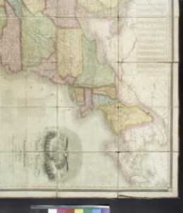
Northern provinces of the United States / drawn & engraved for Thomson's New general atlas, 1817 ; Hewitt Sc. ...
from Charts and maps
Newengland and New York.
from An epitome of Mr. John Speed's Theatre of the empire of Great Britain, and of his Prospect of the most famous parts of the world : in this new edition are added, the descriptions of His Majesties dominions abroad, viz. New England, New York, ... Carolina, Florida, ... Virginia, Maryland, ... Jamaica, Barbados, ... as also the empire of the Great Mogol, with the rest of the East Indies, ... the empire of Russia, with their respective descriptions.
Nova tabula geographica complectens borealiorem Americae partem : in qua exacte delineatae sunt Canada sive Nova Francia, Nova Scotia, Nova Anglia, Novum Belgium, Pensylvania, Virginia, Carolina et Terra Nova : cum omnibus littorum pulvinorumque profundi
from John H. Levine Collection
[Recto], uit: Reading railroad system and connections
Buffalo, N.Y. : The Matthews-Northrup Co.
Etats Unis Flle. N.E.
1 : 5000000 Vivien St Martin, L.
American Atlantic ports N.
1 : 5000000 Philip, George
Nova Belgica Et Anglia Nova [Karte], in: Novus atlas absolutissimus, Bd. 6, S. 202.
1 Karte aus Atlas Janssonius Offizin
Canada, Louisiane et terres angloises / par le Sr. d'Anville ...
from Parts
Canada &c.
1 : 7350000 Lucas, Fielding Jr.
Map of the Seat of War in North America.
1 : 4118400 Melish, John
Map of the Seat of War in North America.
1 : 4118400 Melish, John
N. section U.S.
1 : 4200000 Melish, John
Nova tabula geographica complectens Borealiorem Americae partem, in qua exacte delineatae sunt Canada sive Nova Francia, Nova Scotia, Nova Anglia, Novum Belgium, Pensylvania, Virginia, Carolina, et Terra Nova, cum omnibus littorum pulvinorumque profunditatibus
1 : 4000000 â Nicolao Visscher Luggardus van Anse schulp. Amstlodami : nunc apud Petrus Schenk Junior
Upper Canada &c.
1 : 2154240 Arrowsmith, John
Map of the seat of war in North America / J. Melish del.; H. S. Tanner dirext.
from Parts John Melish; Henry S. Tanner,
Sectional map indicating main automobile roads between Canada and United States
1 : 1900800 Kanada východní National Development Bureau
Northern section of the United States, including Canada &c. / by John Melish, 1816; grav. af. C. F. Himberg.
from Parts John Melish; C. F. Himberg,
Central Vt. RR. excursion routes.
1 : 3830000 Central Vermont Railroad Company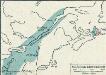
[Québec]
1 : 30000000 Québec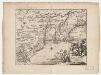
Novi Belgii, quod nunc Novi Jorck vocatur, Novae q[ue] Angliae & partis Virginiae : accuratissima et novissima delineatio
1 : 3500000 Montanus, Arnoldus, 1625?-1683 J. Meurs
Nieuwe en nauwkeurige kaart van een gedeelte van Noord Amerika : behelzende Nieuw Engeland, New York, Pennsylvania, New Jersey, Connecticut, Rhode Island, een stuk van Virginia, Kanada en Halifax, ter opheldering der reizen van den Heer P. Kalm / C.J. de
from Reis door Noord Amerika, gedaan door den Heer Pieter Kalm ... Vercierd met koperen platen ...
Canada.
1 : 7300000 Lucas, Fielding Jr.
Shell Highway Map Northeastern Section of the United States.
1 : 3231360 Shell Oil Company
Northern provinces of the United States / drawn & engraved for Thomson's New general atlas, 1817 ; Hewitt Sc. ...
from Parts