Maps of Appalachian Mountains
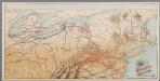
[Recto], uit: Reading railroad system and connections
Buffalo, N.Y. : The Matthews-Northrup Co.
Carte du theatre de la guerre présente en Amerique
1 : 5000000 Nová Anglie Denis, L. Basset, André Basset
Newengland and New York.
from An epitome of Mr. John Speed's Theatre of the empire of Great Britain, and of his Prospect of the most famous parts of the world : in this new edition are added, the descriptions of His Majesties dominions abroad, viz. New England, New York, ... Carolina, Florida, ... Virginia, Maryland, ... Jamaica, Barbados, ... as also the empire of the Great Mogol, with the rest of the East Indies, ... the empire of Russia, with their respective descriptions.
Mappa geographica Americae Septentrionalis: ad emendatiora exemplaria adhuc edita jussu Acad. reg. scient. et eleg. litt. descripta. pars. II.
from Parts Michaelis: [Berolini]; Euler, Leonhard,
Carte generale des colonies angloises dans l'Amerique Septentrionale pour l'intelligence de la guerre presente / d'apres des manuscrit anglais par J. B. Nolin geographe; corrigé, augmenté des indications des principaux évenemens de la guerre avec le tracee des limites pour constituer le traité de paix proposé entre la Couronne de la Grande Bretagne et les Etats Unis, par R. Phelipeau, géographe ... 1783.
from Revolutionary War, 1775-1783 J. B. Nolin; R. Phelipeau,
Theztre de la guerre en Amerique

Composite: Colonie Unite dell' America Settentrle.
1 : 2100000 Zatta, Antonio
Etats Unis et Canada.
1 : 8400000 Montemont, A.
An improved map of the United States
Region Orientale des Etats-Unis, Canada.
1 : 7000000 Levasseur, E.
Carte nouvelle de l'Amerique Angloise
1 : 4400000 Spojené státy americké-oblast východní Lotter, Matthäus Albrecht par Matthieu Albert Lotter
Carte nouvelle de l'Amerique angloise contenant tout ce que les Anglois possedent sur le continent de l'Amerique Septentrionale
1 : 3800000 Spojené státy americké-oblast východní Lotter, Matthäus Albrecht Matthieu Albert Lotter
Die Colonien der Engländer in Nord-America vor und im Revolutions-Krieg
1 : 10000000 von Joh. Val. Kutscheit Freiburg im Breisgau : [Herder]
Map of the United States in North America: with the British, French and Spanish dominions adjoining, according to the Treaty of 1783 / by Thos. Kitchin, Senr., hydrographer to his Majesty.
from Charts and maps Thomas Kitchin, Sr.,
United States - eastern section.
1 : 5000000 John Bartholomew & Co.
Die vereinigten Staaten von Nord-America: nach der von Wm. Faden 1783 herausgegebenen Charte, auf welcher alle im englisch americanischen Kriege vorzüglich merkwürdig gewordenen Örter angezeigt, auch die Grenzen zwischen Grosbrittanien, America und Spanien nach Maasgabe des Friedensschulusses von 1783 bestimmt sind / T. Marianus, Sculp., A.V.; Geschichte der Revolution von Nord-America.
from Geschichte der Revolution von Nord-America. Gegel, Ludwig Bernhard Friederich; Sprengel, M. C. (Matthias Christian),
Part of North America : comprehending the course of the Ohio, New England, New York, New Jersey, Pensilvania, Maryland, Virginia ...
from English pilot. The fourth book.
North America from the French of Mr. D'Anville: improved with the back settlements of Virginia and course of Ohio: illustrated with geographical and historical remarks.
from Charts and maps D'Anville,
Theatrum belli in America Septentrionali: II. foliis comprehensum / jussu Acad[emiis] Reg[iis] Scient[iarum] et Eleg[antium] Litt[erarum] exhibet; I.C. Rhode Ac[ademiae?] Geogr[aphus?]; Berger, sculpsit Berol[ini].
from Parts Berol[ini].,
An accurate map of the English colonies in North America bordering on the River Ohio.
from Parts
United States of America.
1 : 5900000 Cary, John, ca. 1754-1835
A new map of the United States of America, from the latest authorities / by John Cary, engraver.
from Whole John Cary,

Carte nouvelle de l'Amerique angloise contenant tout ce que les Anglois possedent sur le continent de l'Amerique septentrionale savoir le Canada, la Nouvelle Ecosse ou Acadie, les treize Provinces unies qui sont: 1. New Hampshire, 2. Massachusetsbaye, 3. Rhode-Island, & 4. Conecticut, 5. la Nouvelle York, 6. Nouvelle Jersey, 7. Pensilvanie, 8. les Comtés de Newcastle, Kent et Sussex sur la Delaware, 9. Mariland, 10. Virginie, 11. la Caroline Septentrionale, 12. la Caroline Meridionale et 13. Georgie avec la Floride
1 : 5500000 gravée exactement d'après les determinations geographiques dernierement faites par Matthieu Albert Lotter Augsbourg : [Matthäus Albrecht Lotter]
Nova Anglia Novum Belgium et Virginia [Karte], in: Gerardi Mercatoris et I. Hondii Newer Atlas, oder, Grosses Weltbuch, Bd. 2, S. 386.
1 Karte aus Atlas Mercator, Gerhard und Hondius, Jodocus Jansson, Jan
Die Vereinigten Staaten von Nordamerika
1 Karte : Kupferdruck ; 52 x 64 cm Lewis; Arrowsmith in der Schneider- und Weigelschen K.K. privilegirten Kunsthandlung
Canada et Louisiane
1 : 5000000 par le Sr. Le Rouge A Paris : [Le Rouge], Rue des Augustins]
The United States of America confirmed by treaty 1783

![[Recto], uit: Reading railroad system and connections](https://images-2.georeferencer.com/images/iiif/205410793469/full/,300/0/native.jpg)

