Maps of South Africa
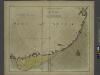
A draught of the south part of AFRICA from cape Bona Esperance to Delagoa
from The sea-atlas : containing an hydrographical description of most of the sea-coasts of the known parts of the world.
South Africa.
1 : 10080000 Peterson, Augusts
Das Capland nebst den süd-afrikanischen Freistaaten un dem Gebiet der Hottentotten & Kaffern.
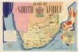
Union of South Afrika
South Africa 40
1 : 4200000 Appleton, D. & Co.
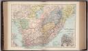
South Africa.
1 : 6000000 Andree, Richard; Times (London, England)
South Africa
A new general atlas of modern geography, consisting of a complete collection of maps of the four quarters of the globe Wyld, James James Wyld
Southern Africa.
1 : 3100000 Hall, S. (Sidney)
Topographical map of the Union of South Africa = Topografiese kaart van die Unie van Suid-Afrika / A.D. Lewis ; comp. in the Office of the Director of Irrigation
1 : 1500000 titelvariant: Topografiese kaart van die Unie van Suid-Afrika Lewis, A. D.; Office of the Director of Irrigation, Zuid-Afrika Pretoria : Government Printer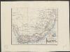
De Kaapkolonie, Transvaal en aangr. landen : periodieke rivieren
1 : 9250000 lith. Emrik & Binger [S.l.] : [s.n.]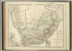
South Africa.
1 : 3817440 Johnston, W. & A.K.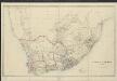
South Africa
1 : 2565000 by James Wyld London : Wyld
Sud. v. Africa.
1 : 3000000 Weiland, C. F. (Carl Ferdinand), d. 1847
[Afrika, Blatt 5]
Adolf Stieler's Handatlas über alle Theile der Erde und über das Weltgebäude Stieler, Adolf Justus Perthes
South Africa.
1 : 4435200 Letts, Son & Co.
A land divided against itself.A map of South Africa showing the African Homelands and some of the mass removals of people which have taken place,..

South Africa [Mineral map of the Union of ] (1959)
Mineral Map of the Union of South Africa. To accompany the handbook, The Mineral Resources of the Union of South Africa" 1959. Delfstofkaart van die Unie van Suid-Afrika." Legends in English and Afrikaans. [Pretoria] : Department of Mines, Union of South Africa.
Kaart van Zuid-Afrika / naar de laatste en beste bronnen bewerkt voor 'De worstelstrijd der Transvalers' door F. Lion Cachet, derde herziene druk ; A.J. Wendel grav
1 : 3000000 Annotatie geografische gegevens: Met schaalstok; Legenda Abraham Jacobus Wendel 1826-1915 Pretoria [etc.] : Boekhandel voorheen Höveker & Wormser / ([Leiden : P.W.M. Trap])
Neueste Karte von Südafrica
Grosser Hand-Atlas über alle Theile der Erde in 170 Karten Meyer, J. Verlag des Bibliographischen Instituts
[Süd-Afrika]
Hand-Atlas über alle Theile der Erde nach dem neuesten Zustande und über das Weltgebäude Stieler, Adolf bei Justus Perthes
Süd-Afrika
Hand-Atlas über alle Theile der Erde nach dem neuesten Zustande und über das Weltgebäude Stieler, Adolf bei Justus Perthes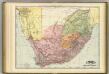
South Africa.
1 : 3200000 Rand McNally and Company
Die Südspitze von Africa mit der Colonie am Vorgebirge der guten Hoffnung und dem Kaffernlande oder Südrand von Africa mit dessen Stufen-laender
1 : 3000000 entworfen und gezeichnet von C. F. Weiland C. Jungmann sc. Weimar : Verlag des Geograph. Instituts
Die Südspitze von Africa mit der Colonie der Guten Hoffnung und dem Kaffern-Lande oder Südrand von Africa und dessen Stufenlaender
1 : 3000000 Jihoafrická republika Weiland, Karl Ferdinand Geograph. Instituts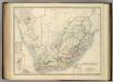
South Africa.
1 : 3817440 Johnston, Alexander Keith
Mission map of South Africa according to the map in Stieler's Atlas

Sud-Africa.
1 : 4700000 Flemming, Carl
Sudafrica.
1 : 5250000 Radefeld, Carl Christian Franz, 1788-1874
South Africa, Cape Colony.
1 : 7180000 Higgins, W.M.


