Maps of Mozambique
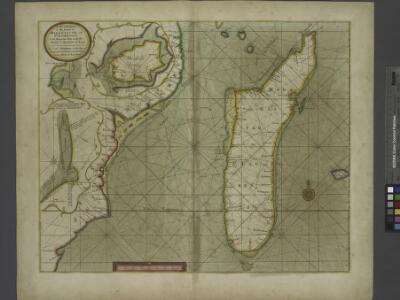
A new draught of the Island of MADAGASCAR ats St. LORENZO with Augustin Bay and the Island of Mombass at Large
from The sea-atlas : containing an hydrographical description of most of the sea-coasts of the known parts of the world.
Le canal de Mosambique, l'isle de Madagascar, les etats du Monomotapa et les royaumes voisins
1 : 9600000 Madagaskar Bonne, Rigobert André
Spezial - karte von AfricaSektion Delacoa Bai (10)
1 : 4000000 1 full d'1 mapa en 10 fulls i estoig Hermann Habenicht; Justus Perthes
[Afrika, Blatt 6]
Adolf Stieler's Handatlas über alle Theile der Erde und über das Weltgebäude Stieler, Adolf Justus Perthes
Spezial-Karte von Afrika
1 : 4000000 Blatt 10 Habenicht, Hermann Perthes
Afrique, cote orientale.
1 : 7000000 Bonne, Rigobert, 1727-1794
Topographical map of the Island of Madagascar
1 : 4580000 from the original design drawn on the spot by M. Roberts S.I. Neele sculpt. London : [s.n.]
Carte Particuliere De L'Isle Dauphine ou Madagascar Et St. Laurens, Levée Par Ordre Expres des Roys De Portugal sous qui on en a Fait la Decouverte. [Karte], in: Atlas nouveau, contenant toutes les parties du monde [...], Bd. 2, S. 225.
1 Karte aus Atlas Sanson, Nicolas Jaillot, Alexis Hubert und Mortier, Pieter
Die Ostküste Süd-Africa's nebst der Insel Madagascar, den Comoren, Sechellen, Amiranten und Mascarenischen Inseln
1 : 5480000 entworfen von C.F. Weiland gestochen von Mädel med. Weimar : Geographisches Institut
CHARTE von einem Theile der OST-KÜSTE VON Africa
Afrika východní
Charte von einem Theile der Ost-Küste von Africa
Afrika východní
INSVLA S. LAVRENTII, | Vulgo | MADAGASCAR.
[Amsterdam : Joan Blaeu]
Madagascar
Vidal de La Blache, Paul
Madagaskar
1 : 4000000 Annotatie geografische gegevens: Aangegeven zijn Franse en Engelse scheepvaartroutes Glogau : Carl Flemming
Map of Portuguese East Africa
1 : 3000000 Afrika východní Mining and Industrial Publications of Africa
Madagascar.
1 : 2661120 Stanford, Edward
Carte de l'ile de Madagascar
1 : 4500000 réd. par B.F. Leguével de la Combe d'après ses reconnaissances, ses itinéraires, et les cartes du Depôt de la Marine dressée par A. H. Dufour ; la topographie par Felix Charpentier ; la lettre par Ch. Simon Paris : chez Desessart
Madagascar
1 : 5500000 Madagaskar Service géographique
Carte des missions catholiques à Madagascar
1 : 1776000 [Lyon : Oeuvre de la propagation de la foi]
Madagascar, carte hypsométrique
1 : 3500000 Madagascar. Service géographique [Tananarive] : Service géographique du Corps d'occupation
Madagascar, carte hydrographique
1 : 3500000 Madagascar. Service géographique [Tananarive] : Service géographique du Corps d'occupation
Madagascar, carte forestière
1 : 3500000 Madagascar. Service géographique [Tananarive] : Service géographique du Corps d'occupation
Madagascar, carte d'ensemble
1 : 3500000 Madagascar. Service géographique [Tananarive] : Service géographique du Corps d'occupation
Madagascar, carte minière
1 : 3500000 Madagascar. Service géographique [Tananarive] : Service géographique Corps d'occupation
Carte de Madagascar / publiée par le Service Géographique de l'Armée
1 : 2000000 Annotatie geografische gegevens: Inzetkrt.: Partie sud de Nosy-Bé. - 1:200.000; Baie de Diego-Suarez. - 1:200.000 Service Géographique de l'Armée [S.l. : Service Géographique de l'Armée]
Géodésie de Madagascar. Triangulation de 1898
1 : 2500000
Géodésie de Madagascar. Triangulation de 1895 à 1900
1 : 2500000
Géodésie de Madagascar. Triangulation de 1899
1 : 2500000
Géodésie de Madagascar. Triangulation antérieure à 1898
1 : 2500000