Maps of Northern Ireland
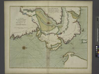
A chart of the sea coast of IRELAND from Dublin to London-Derry
from The sea-atlas : containing an hydrographical description of most of the sea-coasts of the known parts of the world.
Ireland 2.
1 : 760320 Letts, Son & Co.
[Ultonia, Connatia und Media] [Karte], in: Gerardi Mercatoris Atlas, sive, Cosmographicae meditationes de fabrica mundi et fabricati figura, S. 91.
1 Karte aus Atlas Mercator, Gerhard Montanus, Petrus
[Ultonia, Connatia und Media] [Karte], in: Atlas, sive, Cosmographicae meditationes de fabrica mundi et fabricati figura, S. 95.
1 Karte aus Atlas Mercator, Gerhard

Charte von England und Wallis, 1
1 Blatt : 62 x 53 cm Walch
Karte von England und Wallis, 1
1 Blatt : 63 x 54 cm Schrämbl
Le royaume d'Irlande
1 Karte auf 2 Blättern : Kupferdruck ; 87 x 60 cm Jaillot; Sanson chez H. Iaillot
Ireland NE.
1 : 486830 Stanford, Edward
Ultoniae Orientalis. Pars [Karte], in: Gerardi Mercatoris Atlas, sive, Cosmographicae meditationes de fabrica mundi et fabricati figura, S. 94.
1 Karte aus Atlas Mercator, Gerhard Montanus, Petrus
Parte del regno d'Irlandia, cioè le provincie d'Ulster, e Leinster
1 Karte : Kupferdruck ; 40 x 30 cm Zatta; Zuliani; Pitteri presso Antonio Zatta
delineation of the strata of England and Wales, with part of Scotland
1 : 320000 Blatt 3 Smith, William Cary
Belfast
1 : 250000 Belfast (Severní Irsko) War Office
Ultoniae Orientalis. Pars [Karte], in: Atlas, sive, Cosmographicae meditationes de fabrica mundi et fabricati figura, S. 101.
1 Karte aus Atlas Mercator, Gerhard
Vltonia; hibernis Cvi-Gvilly; anglis Vlster
1 Karte : Kupferdruck ; 40 x 48 cm Blaeu Joan Blaeu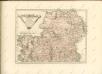
Ireland (northern)
1 : 700000 Lizars, Daniel
VLTONIA; | Hibernis CUI-GUILLY; | Anglis VLSTER.
[Amsterdam : Joan Blaeu]
Provincia Ultoniae The Province of Ulster [Karte], in: Gerardi Mercatoris et I. Hondii Newer Atlas, oder, Grosses Weltbuch, Bd. 1, S. 63.
1 Karte aus Atlas Mercator, Gerhard und Hondius, Jodocus Jansson, Jan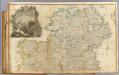
Ireland (north)
1 : 380000 Rocque, John
Provincia Ultoniae The Province of Ulster [Karte], in: Novus atlas absolutissimus, Bd. 8, S. 201.
1 Karte aus Atlas Janssonius Offizin
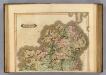
Provincia Ultoniae = The province of Ulster
1 : 690000 Amstelodami : apud Joannem Janssonium
Ulster
This is a map of the six ‘escheated’ counties of Ulster. It dates from 1609 and may be by John Norden, though likely to be based on the barony maps of Josias Bodley and William Parsons. It seems to be intended as a guide to planned plantings. In 1607 the earls of Ulster fled and the counties of Armagh, Cavan, Coleraine, Donegal, Fermanagh and Tyrone were confiscated by the English and the Scots. In 1608-9 the Commons had drafted plans for English and Scottish planting and lands that were to be retained by the Irish. Norden, John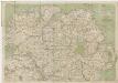
[Kaart], uit: Cycling map of Ireland : north sheet
1 : 400000 London : Bacon
Watershed map England, Wales 1.
1 : 760320 Letts, Son & Co.
England and Wales. England No. 2.
1 : 700000 Society for the Diffusion of Useful Knowledge (Great Britain)
Vltoniae orientalis. pars
1 Karte : Kupferdruck ; 33 x 36 cm Mercator; Hondius Henricus Hondius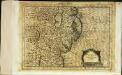
Vltoniæ orientalis pars
1 Karte : Kupferdruck ; 17 x 24 cm Mercator Cloppenburgh
Vltoniae orientalis. pars
1 Karte : Kupferdruck ; 33 x 36 cm Mercator; Hondius Jodocus Hondius