Maps of Saratoga County

Northumberland [Township]
from New topographical atlas of Saratoga Co., New York, from actual surveys by S. N. & D. G. Beers and assistants.
Schuylerville
1 : 62500
Schuylerville
1 : 62500
Schuylerville
1 : 62500
Schuylerville
1 : 62500
Schuylerville
1 : 62500
Schuylerville
1 : 62500
Schuylerville
1 : 62500
Schuylerville
1 : 62500
Schuylerville
1 : 62500
Schuylerville
1 : 62500
Schuylerville
1 : 62500
Schuylerville
1 : 62500
Gansevoort
1 : 24000
Gansevoort
1 : 24000
Gansevoort
1 : 24000
Gansevoort
1 : 24000
Ft Miller
1 : 24000
Ft Miller
1 : 24000
Fort Miller
1 : 24000
Schuylerville Business Directory. ; Schuylerville [Village]
from New topographical atlas of Saratoga Co., New York, from actual surveys by S. N. & D. G. Beers and assistants.
Bloodville [Village]; Bloodville Business Directory. ; Rock City Falls Business Directory. ; Rock City [Village]; Gansevoort Business Directory. ; Gansevoort [Village]; Vischers Ferry Business Directory. ; Vischers Ferry [Village]; West Milton Business D
from New topographical atlas of Saratoga Co., New York, from actual surveys by S. N. & D. G. Beers and assistants.
Grangerville [Village]; Grangerville Business Directory. ; Victory [Village]; Charlton [Village]; Charlton Business Directory. ; Victory Business Directory. ; Rexford Flats Business Directory. ; Rexford Flats [Village]
from New topographical atlas of Saratoga Co., New York, from actual surveys by S. N. & D. G. Beers and assistants.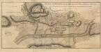
Plan of the position which the Army under Lt Genl Burgoine took at saratoga on the 10th of Septr, 1777,
Plan of the position which the Army under Lt. Genl. Burgoine took at saratoga on the 10th of Septr., 1777, and in which it remained till the Convention was signed. London
Wilton [Township]
from New topographical atlas of Saratoga Co., New York, from actual surveys by S. N. & D. G. Beers and assistants.
Moreau [Township]
from New topographical atlas of Saratoga Co., New York, from actual surveys by S. N. & D. G. Beers and assistants.
Saratoga [Township]
from New topographical atlas of Saratoga Co., New York, from actual surveys by S. N. & D. G. Beers and assistants.
Wilton, Saratoga County, New York.
1 : 42240 Beers, B.G.
Quaker Springs
1 : 24000
Quaker Springs
1 : 24000
![Northumberland [Township]](https://images-2.georeferencer.com/images/iiif/912056991897/full/,300/0/native.jpg)

