Maps of Saratoga Springs

Quaker Springs
1 : 24000
Quaker Springs
1 : 24000
Quaker Springs
1 : 24000
Schuylerville Business Directory. ; Schuylerville [Village]
from New topographical atlas of Saratoga Co., New York, from actual surveys by S. N. & D. G. Beers and assistants.
Saratoga [Township]
from New topographical atlas of Saratoga Co., New York, from actual surveys by S. N. & D. G. Beers and assistants.
Schuylerville
1 : 62500
Schuylerville
1 : 62500
Schuylerville
1 : 62500
Schuylerville
1 : 62500
Schuylerville
1 : 62500
Schuylerville
1 : 62500
Schuylerville
1 : 62500
Schuylerville
1 : 62500
Schuylerville
1 : 62500
Schuylerville
1 : 62500
Schuylerville
1 : 62500
Schuylerville
1 : 62500
Saratoga Springs [Township]
from New topographical atlas of Saratoga Co., New York, from actual surveys by S. N. & D. G. Beers and assistants.
Saratoga Springs, Saratoga County, New York.
1 : 42240 Beers, B.G.
Plan of the Encampment and position of the Army under General Burgoyne at Sword's House on Hudson's River
Plan of the Encampment and position of the Army under ... General Burgoyne at Sword's House on Hudson's River near Stillwater on Sept. 17th, with the Positions of that part of the Army engaged on the 19th Sept., 1777. Drawn by W.C. Wilkinson ... Engraved [and] published by W. Faden. London
Wilton [Township]
from New topographical atlas of Saratoga Co., New York, from actual surveys by S. N. & D. G. Beers and assistants.
Stillwater [Township]
from New topographical atlas of Saratoga Co., New York, from actual surveys by S. N. & D. G. Beers and assistants.
Northumberland [Township]
from New topographical atlas of Saratoga Co., New York, from actual surveys by S. N. & D. G. Beers and assistants.
Stillwater, Saratoga County, New York.
1 : 42240 Beers, B.G.
Malta [Township]
from New topographical atlas of Saratoga Co., New York, from actual surveys by S. N. & D. G. Beers and assistants.
Wilton, Saratoga County, New York.
1 : 42240 Beers, B.G.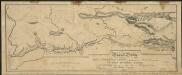
Map and profile of the Champlain Canal as made from Lake Champlain to the Hudson River and surveyed thence to the tide at Waterford
1 : 190080 Geddes, James
Map of the county of Montgomery and Fulton / by David H. Burr; engd. by Rawdon, Clark & Co., Alby., & Rawdon, Wright & Co., N. York.; An atlas of the state of New York, designed for the use of engineers, containing a map of the state and of the several counties. / Projected and drawn ... under the superintendence and direction of Simeon de Witt.
from An atlas of the state of New York, designed for the use of engineers, containing a map of the state and of the several counties. / Projected and drawn ... under the superintendence and direction of Simeon de Witt. Burr, David H.; De Witt, Simeon; Rawdon, Clark & Co.; Rawdon, Wright & Co.; Stone & Clark Republishers,
Saratoga County.
1 : 151000 Burr, David H., 1803-1875

