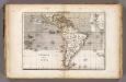
Maps of South America
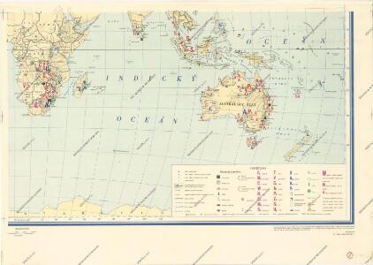
Světová těžba nerostných surovin

A map of South America and the adjacent islands, 1794.
from The American geography; or, A view of the present situation of the United States of America: containing astronomical geography; geographical definitions, discovery, and general description ... By Jedidiah Morse, A.M.
Carte de l'Amérique Méridionale
1 : 15000000 Orbigny, Alcide Dessalines d', 1802-1857 Pitois-Levrault et Cie Libraire
Rand, McNally & Co.'s new 14 x 21 map of South America
1 : 19008000 Rand McNally and Company Rand, McNally & Co.
Novae Insulae, XXVI. Nova Tabula. [Karte], in: Claud. Ptolemaeus. Geographia lat. cum mappis [...], S. 440.
1 Karte aus Atlas Münster, Sebastian [und Ptolemaeus, Claudius]
South America and the Adjacent Islands.
1 : 3450000 Morse, Jedidiah

Novae Insulae, XVII. Nova Tabula. [Karte], in: Geographia universalis vetus et nova complectens Claudii Ptolemaei Alexandrini enarrationis libros VIII, S. 347.
1 Karte aus Atlas Münster, Sebastian [und Ptolemaeus, Claudius]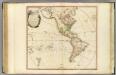
America.
1 : 42000000 Faden, William, 1750?-1836
America
Hand-Atlas über alle Theile der Erde nach dem neuesten Zustande und über das Weltgebäude Stieler, Adolf bei Justus Perthes
Hospodářská mapa světa - těžba nerostných surovin
Vents (Amerique)
1 : 50000000 Vincent
South America
Este mapa, sin fecha y sin autor conocido, probablemente sea de mediados del siglo XVIII. La representación de Islas Malvinas a partir del Estrecho de Falkland, como era común en la primera mitad del siglo XVIII, es un indicio en ese sentido. En enero de 1690 el inglés John Strong navegó entre las dos islas principales y llamó al paso "Falkland Channel" en honor a su mecenas el Vizconde de Falkland que como había financiado la expedición. La cartografía británica adoptaría en el siglo XVIII el nombre del canal, para designar a todo el grupo de islas, que reclamaría para Inglaterra, en contra de España. En 1740 hubo un enfrentamiento naval entre las fuerzas británicas y españolas por las islas, sin un claro vencedor. Las tensiones entre los dos imperios continuaría a lo largo del siglo XVIII.
South America.
from A new sett of maps both of antient and present geography : wherein not only the latitude and longitude of many places are corrected according to the latest observations, but also the most remarkable differences of antient and present geography may be quickly discern'd by a bare inspection or comparing of correspondent maps, which seems to be the most natural and easy method to lead young students (for whose use the work is principally intended) unto a competent knowledge of the geographical science : together with a geographical treatise particularly adapted to the use and design of these maps / by Edward Wells, M.A. and student of Christ-Church, Oxon.
South America.
1 : 25344000 Carey, Mathew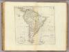
Map Of South America.
1 : 25344000 Carey, Mathew
South America.
1 : 26000000 Carey, Mathew
Map Of South America.
1 : 25344000 Carey, Mathew
Amerika Historisch, Physisch und Politisch vom Jahr 1828
Historisch-genealogisch-geographischer Atlas von Le Sage Las Cases, Emmanuel Auguste Dieudonné Marius Joseph de Johann Velten, Kunsthändler
Composite: America.
1 : 13000000 Robert Laurie & James Whittle
Composite: America.
1 : 12800000 Sayer, Robert
America noviter delineata [Karte] [Arktis] [und] Terra Australis Incognita [2 Nebenkarten], in: Novus atlas absolutissimus, Bd. 6, S. 191.
1 Karte aus Atlas Janssonius Offizin
America
Amerika im Verlage des Kunst und Industrie Comptoirs
America
Amerika im Verlage des Kunst und Industrie Comptoirs
City of Sydney, Sections 56,57 & 58, 1888
New South Wales. Department of Lands
L'Amerique
1 Karte : Kupferdruck ; 48 x 62 cm Charlevoix; Le Rouge; La Condamine chez Le Rouge rue des gr.s Augustins
L'Amerique
1 Karte : Kupferdruck ; 48 x 62 cm Charlevoix; Crépy; La Condamine; Crépy chez Crepy rue S. Jacque à S. Pierre près la rue de la parcheminerie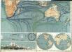
Physikalische Wandkarte der Erde in Merkartor's Projection