Maps of Hrodna Region

Übersichtskarte von Mittel - Europa

Übersichtskarte von Mittel - Europa

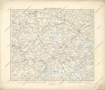
Wilna, Minsk, Grodno, Słonim
1 : 750000 Grodno (Bělorusko : oblast) Jakupec, M. K. u. k. Militärgeographisches Institut
Wilna, Minsk, Grodno, Słonim
1 : 750000 Grodno (Bělorusko : oblast) K. k. militär-geographisches Institut
Wiłkomierz, Dwinsk (Dünaburg), Wilna, Wilejka, Słonim, Mińsk
1 : 300000 Minsk (Bělorusko : oblast)
Raspoloženīe 1 i 2 armīi pered vojnoju.
Litauen Weißrussland Napoleonische Kriege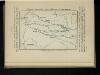
Karta di’jstvij ot‘‘ Bereziny k‘‘ Vil’ně
Litauen Vilnius Russlandfeldzug <1812>
Zdzienciol, Gorodischtsche, Derewna, Ljachowitschi
1 : 100000 Bělorusko
Trigonometrisk grunnlag, vedlegg 65, 6-9: Grunnlagspunkter for Struves meridianbue fra Vilnius, Hrodna og Kurland
1 : 200000 de Tenner
Nowogródek

Grodno-Ost, Ostryna, Bielica, Indura, Mosty, Wenzowiec, Swislocz, Wolkowyßk, Slonim
1 : 100000 Bělorusko
Iwje, Ljubtscha, Nowogródek, Korelitschi, Zdzienciol, Gorodischtsche
1 : 100000 Dzjatlava (Bělorusko)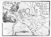
Vilnius. XVIII. šimtmečio pabaigoje
Vilnius Altstadt
Delineatio memorabilis conflictus et victoriae Lithuanorum Duce Radivilio de Cricevio
Bělorusko
Castra defensiva Ducis Radiuly Reciciae, obiecta aduentui Eliae Bohaczenlio
Bělorusko
[Litauen, Lettland]
Litauen, Lettland, ethnische Gruppe
Li palatinati di Nowogrodek Podlachia e Brzesk Littew / tratta dall'atlante polacco del Sig.r Rizzi
1 : 1300000 1 Karte : Kupferdruck ; 31 x 40 cm Zuliani, Giuliano presso Antonio Zatta
Kartenskizze des polnisch-weißrussischen Grenzgebietes
Polen Weißrussland Grenzgebiet
Geologičeskaja karta Polěs'ja
1 : 1250000 Polesí
Raspoloženīe vojska 1. ījulja.
Litauen Weißrussland Russlandfeldzug <1812>
Mapa narodowościowa polskich kresów północno-wschodnich i Litwy
1 : 1000000 Litva Machlejd, Jerzy Zaborski, Bogdan Gebethner & Wolff
Gipsometričeskaja karta Polěs'ja s oboznačenijem kanalizacii
1 : 1250000 Polesí
[Lietuvos žemelapis]
Litva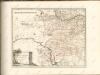

[Recto], uit: Archangel Port : revised plan of saw mills and loading places
1 : 90000 Annotatie geografische gegevens: Met legenda, 1-45 Archangel : A.J. Anderson & Son
Nr. 21a. Weitere Ergebnisse der Winterschlacht in Masuren
Masuren Weltkrieg <1914-1918>, Ostfront
[Vilnius a okolí]
1 : 38000 Vilnius-oblast (Litva) Frolov
Plan mi''stopoloženija meždu Borisovym i Zembinom
Russland Borisov Russlandfeldzug <1812>
Die Beresina
1 : 500000 Beresina-Gebiet Schlacht an der Beresina