Maps of Vilniaus

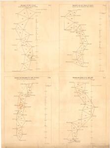
Trigonometrisk grunnlag, vedlegg 65, 6-9: Grunnlagspunkter for Struves meridianbue fra Vilnius, Hrodna og Kurland
1 : 200000 de Tenner
[Vilnius a okolí]
1 : 38000 Vilnius-oblast (Litva) Frolov
Iwje, Ljubtscha, Nowogródek, Korelitschi, Zdzienciol, Gorodischtsche
1 : 100000 Dzjatlava (Bělorusko)
Nowogródek
Vilnius. XVIII. šimtmečio pabaigoje
Vilnius Altstadt
Wiłkomierz, Dwinsk (Dünaburg), Wilna, Wilejka, Słonim, Mińsk
1 : 300000 Minsk (Bělorusko : oblast)
[Lietuvos žemelapis]
Litva
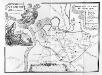
Raspoloženīe 1 i 2 armīi pered vojnoju.
Litauen Weißrussland Napoleonische Kriege
Raspoloženīe vojska 1. ījulja.
Litauen Weißrussland Russlandfeldzug <1812>
Karta di’jstvij ot‘‘ Bereziny k‘‘ Vil’ně
Litauen Vilnius Russlandfeldzug <1812>
Paasche's Frontenkarte, Nr.10. Der Krieg gegen Russland

Übersichtskarte von Mittel - Europa

Übersichtskarte von Mittel - Europa

Wilna, Minsk, Grodno, Słonim
1 : 750000 Grodno (Bělorusko : oblast) Jakupec, M. K. u. k. Militärgeographisches Institut
Wilna, Minsk, Grodno, Słonim
1 : 750000 Grodno (Bělorusko : oblast) K. k. militär-geographisches Institut
Poland, Western Russia, Latvia and Lithuania [A map of]
This is sheet 322 of a series of maps was prepared for the German Army, and its numeration continues that of the Karte des Deutschen Reiches. Grossblatt 308-441A. [A map of Poland, western Russia, Latvia, and Lithuania, drawn in extension of the Karte des Deutschen Reiches 1:100,000 published by the Reichsamt für Landesaufnahme.]. Germany. Heer. Abteilung für Kriegskarten- und Vermessungswesen. [S.l.] : Hergestellt im Auftrage Gen St d H Abt f Kr Kart u Verm Wes (II)
Grodno-Ost, Ostryna, Bielica, Indura, Mosty, Wenzowiec, Swislocz, Wolkowyßk, Slonim
1 : 100000 Bělorusko
Mapa narodowościowa polskich kresów północno-wschodnich i Litwy
1 : 1000000 Litva Machlejd, Jerzy Zaborski, Bogdan Gebethner & Wolff
Kartenskizze des polnisch-weißrussischen Grenzgebietes
Polen Weißrussland Grenzgebiet
Verwaltungsgebiet Ober Ost und geschlossene Sprachgebiete
Baltikum Oberost Weltkrieg <1914-1918>
Verwaltungsgebiet Ober Ost. Einteilung der Kreise und Eisenbahnlinien
Baltikum Oberost Weltkrieg <1914-1918> Eisenbahnnetz
Delineatio memorabilis conflictus et victoriae Lithuanorum Duce Radivilio de Cricevio
Bělorusko
Castra defensiva Ducis Radiuly Reciciae, obiecta aduentui Eliae Bohaczenlio
Bělorusko
Kalnuotumo ir nuotakumo Lietuvos
1 : 630000 Lotyšsko Matulionis, P. S. Schropp'sche Lehrmittel-Handlung
[Litauen, Lettland]
Litauen, Lettland, ethnische Gruppe

Carte des operations du corps d'armée commandé par le général polonais, Henri Dembinski en 1831
Litauen Weißrussland Polen / Aufstand <1830-1831> Dembiński, Henryk Dembiński, Henryk
Litauen, O. Pruisen en Noord Gouv. Gen.
1 : 3000000 Annotatie: Vrijgegeven door W.B.N. 15-5-'44 Den Haag : Kompas
Mapa nowej unji Polski z Litwą
1 : 2000000 Bělorusko Romer, Eugeniusz Instytut kartograficzny Atlas