Maps of Metropolitan France

Francie, Belgie, Nizozemí, Lucembursko
LA FRANCE en 1812
Francie Las Cases, Emmanuel-Auguste-Dieudonné Didot, Pierre Jules Didot Ainé
[Frankreich]
Historisch-genealogisch-geographischer Atlas von Le Sage Las Cases, Emmanuel Auguste Dieudonné Marius Joseph de Johann Velten, Kunsthändler
Nouvelle carte de poste de tout l'empire Français, de l'Anglettere, de l'Italie, d'une partie de l'Espagne et de l'Allemagne etc
Anglie Hinrichs, Johann Conrad J.C. Hinrichs
Gallia
1 : 4250000 Francie Plancius, Petrus Petrus Plancius
Carte générale de l'Empire Français et du Royaume d'Italie suivant les nouvelles divisions : avec les chefs-lieux de préfecture et l'indication des principales routes
1 : 2000000 par C.F. Delamarche Barriere sculpsit. À Paris : chez l'auteur
Nouvelle carte de poste de tout l'empire Français, de l'Angleterre, de l'Italie, d'une partie de l'Espagne et de l'Allemagne, etc. = Neueste Post Karte vom ganzen Französischen Reiche, England, Italien, und einem Theile von Spanien und Deutschland uzw. / hrsg. und verlegt von J.C. Hinrichs
1 : 2800000 Hinrichs, J. C. Leipzig : Hinrichs
Charte von Frankreich
1 : 2400000 Francie Streit, Friedrich Wilhelm Geograph. Instituts
Charte von Frankreich
1 : 2400000 Francie Streit, Friedrich Wilhelm Geograph. Instituts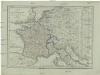
Karte von Frankreich
1 : 4500000 Belgie Mollo, Tranquillo Tranquillo Mollo
Carte de la France : divisée en 133 départements et en arrondissements communaux ... / par J.B. Poirson
1 : 1750000 titelvariant: Carte de l'empire Français; Annotatie: Omslagtitel: Carte de l'empire Français Poirson, J. B. Paris : Jean
30-31. Francia, France.
1 : 3000000 Touring club italiano
[Historisch-geographischer Atlas zu den allgemeinen Geschichtswerken von C. v. Rotteck, Pölitz u. Becker] : Frankreich eine Uebersicht der Bildung und der Hauptbegebenheiten dieses Staates
von Julius Loewenberg Lithographie von B. Herder in Freiburg im Breisgau [Freiburg im Breisgau] : [Herder]
Le royaume de France
1 Karte : Kupferdruck ; 46 x 55 cm Seutter Matthäus Seutter
Outline Europe.
1 : 4600000 Wauthier, J. M.
Europe.
1 : 4600000 Wauthier, J. M.
Galliae Regni Potentiss: Nova Descriptio [Karte], in: Theatrum orbis terrarum, S. 63.
1 Karte aus Atlas Ortelius, Abraham
Galliae Regni Potentiss: Nova Descriptio [Karte], in: Theatrum orbis terrarum, S. 110.
1 Karte aus Atlas Ortelius, Abraham Vrients, Jan Baptista
Carte aéronautique de France
Service Géographique de l'Armée
Gallia Antiqua.
1 : 2500000 Anville, Jean Baptiste Bourguignon d, 1697-1782
Galliae Regni Potentiss: Nova Descriptio. [Karte], in: Theatrum orbis terrarum, S. 30.
1 Karte aus Atlas Ortelius, Abraham
Der Sieg im Westen [Victory in the West]

La France
1 Karte : Kupferdruck ; 48 x 56 cm Navarre; Tardieu; André; Mondhare; Jean chez Mondhare et Jean rue St. Jean de Beauvais pres celle des Noyers quartier place Maubert
La France
1 Karte auf 2 Blättern : Kupferdruck ; 72 x 102 cm Nolin; Longchamps; Cassini de Thury chés Longchamps ruë St. Jacques à l'enseigne de la place des Victoires
Frankreich mit Piemont, Schweiz, Baden, Württemberg, Rhein-Provinz, Hessen und Belgien
1 : 1200000 Belgie Geographisches Institut
Gallia et Germania ultimorum Romani Imperii temporum aequalis
1 : 4000000 Mollova mapová sbírka Liebe, Christian Sigismund
Die Reiche der Carolinger
1 : 8400000 Evropa západní
L'Empre. de Charlemagne de 768 a 814.
1 : 5800000 Houze, Antoine Philippe
France.
1 : 4550000 Darton, William


