Maps of Štěrboholy

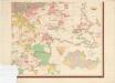
Orientační plán hlavního města Prahy s okolím

Orientační plán hlavního města Prahy s okolím
1 : 5000
Stěrboholl - c7780-1-002 - Kaiserpflichtexemplar der Landkarten des stabilen Katasters
1 : 2880
Stěrboholl - c7780-1-001 - Kaiserpflichtexemplar der Landkarten des stabilen Katasters
1 : 2880
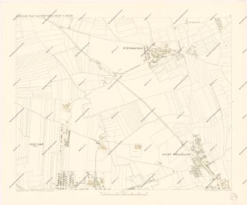
Unter Miecholup (Dolno Mecholupi) - c1341-1-002 - Kaiserpflichtexemplar der Landkarten des stabilen Katasters
1 : 2880
Unter Miecholup (Dolno Mecholupi) - c1341-1-001 - Kaiserpflichtexemplar der Landkarten des stabilen Katasters
1 : 2880
Unter Miecholup (Dolno Mecholupi) - c1341-1-003 - Kaiserpflichtexemplar der Landkarten des stabilen Katasters
1 : 2880
Hlavní město Praha s okolím
Orientierungsplan der Hauptstadt Prag
Jiřík, Rudolf
Hostiwarz (Hostiwarze) - c2250-1-004 - Kaiserpflichtexemplar der Landkarten des stabilen Katasters
1 : 2880
Hostiwarz (Hostiwarze) - c2250-1-005 - Kaiserpflichtexemplar der Landkarten des stabilen Katasters
1 : 2880
Hostiwarz (Hostiwarze) - c2250-1-003 - Kaiserpflichtexemplar der Landkarten des stabilen Katasters
1 : 2880
Hostiwarz (Hostiwarze) - c2250-1-006 - Kaiserpflichtexemplar der Landkarten des stabilen Katasters
1 : 2880
Hostiwarz (Hostiwarze) - c2250-1-001 - Kaiserpflichtexemplar der Landkarten des stabilen Katasters
1 : 2880
Hostiwarz (Hostiwarze) - c2250-1-002 - Kaiserpflichtexemplar der Landkarten des stabilen Katasters
1 : 2880
Orientační plán hlavního města Prahy s okolím

Malleschitz - c4410-1-002 - Kaiserpflichtexemplar der Landkarten des stabilen Katasters
1 : 2880
Malleschitz - c4410-1-003 - Kaiserpflichtexemplar der Landkarten des stabilen Katasters
1 : 2880
Malleschitz - c4410-1-001 - Kaiserpflichtexemplar der Landkarten des stabilen Katasters
1 : 2880
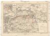
Schlacht bei Prag, den 6-ten May 1757

Orientační plán Hlavního města Prahy
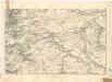
Umgebung von Prag
Plan der Schlacht bei Prag am 6ten Mai 1757
1 : 25000 Štěrboholy (Praha, Česko) Hoen, Maximilian von L.W. Seidel & Sohn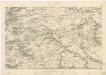
Umgebung von Prag IV.
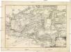
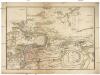
Bataille de Praag, en Bohéme, gagnée par le roi de Prusse, sur l'armée des impériaux, commandée par le prince Charles de Lorraine, le 6. may, 1757
1 : 39000 Praha (Česko)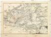
Bataille de Praag, en Bohéme, gagnée par le roi de Prusse, sur l'armée des impériaux, commandée par le prince Charles de Lorraine, le 6. may, 1757
1 : 39000 Praha (Česko)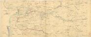
Bez titulu: Plán železniční dopravy v Praze a okolí

Výškopisný plán hlavního města Prahy s okolím

Bataille de Prague
1 : 62300 Praha (Česko) Therbu Coentgen, Heinrich Hugo