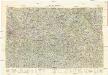
Maps of Northeast

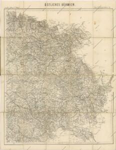
Östliches Böhmen

Východní Čechy
1 : 22000
Prozkoumání Čech, sekce VI.

Církevní mapa biskupství Králové-Hradeckého

Mappa dioeceseos Reginaehradecensis
1 : 190000 Chrudim (Česko) Venuto, Jan Antonín Hay, Jan Leopold
Mappa dioceseos Reginaehradecensis in usum et commodum venerabilis cleridiocesani delineata
1 : 190000 Kraj Vysočina (Česko : 2000-) Venuto, Jan Antonín Hay, Jan Leopold
Mappa dioeceseos Reginaehradecensis
1 : 190000 Chrudim (Česko) Venuto, Jan Antonín Hay, Jan Leopold
Mappa dioeceseos Reginaehradecensis
1 : 190000 Chrudim (Česko) Venuto, Jan Antonín Hay, Jan Leopold
Mappa dioeceseos Reginaehradecensis
1 : 190000 Chrudim (Česko) Venuto, Jan Antonín Hay, Jan Leopold
Kraj Hradecký
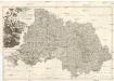
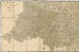
PROVINCIA REGINOHRADECENSIS et COMITATUS GLACENSIS
Hradec Králové-oblast (Česko) Bernardi, Augustin Augustin Bernardi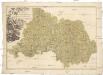
Provincia Reginohradecensis et comitatus Glacensis
Kladsko-oblast (Polsko) Müller, Johann Christoph Winkler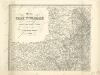
Mapa země moravské

General Karte der Markgrafschaft Mähren und des Herzogthums Schlesien

Atlas Bohemiae

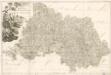
Regni Bohemiae Circuli Biczoviensis et Regionhradecensis...
Bidschower und Konigrätzer Kreis...

Region Královehradecký
1 : 350000
Region Královehradecký
1 : 350000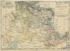
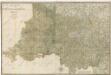
Charte ehemalinger Burgen u. Festen im Bidžower u Koeniggrätzer Kreise Böhmens
Bidschower und Konigrätzer Kreis...
M. Provincia Reginohradecensis et Comitatus Glacensis

Kraj hradecký

A. Bidschover und B. Königingratzer Kreis samt der Grafschaft Glatz
1 : 200000 Hradec Králové-oblast (Česko) Peter Franza
A. Bidschover und B. Königingratzer Kreis samt der Grafschaft Glatz
1 : 200000 Hradec Králové-oblast (Česko) Peter Franza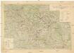
Území Východočeské elektrárny akc. spol. Hradec Králové II
1 : 200000 Čechy východní (Česko) Vojenský zeměpisný ústav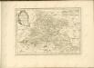

Kriegsschauplatz Nordböhmen 1866
1 : 200000 Čechy severní (Česko) K. u. k. militär-geographisches Institut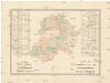
R. 1889 Českým sněmem navržený obvod obchodní komory pro východní Čechy
Čechy východní (Česko) Milbauer, Emanuel Vlastimil