Maps of Northeast
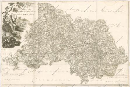
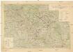
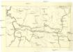
M. Provincia Reginohradecensis et Comitatus Glacensis
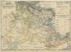
Bidschower und Konigrätzer Kreis...
Bidschower und Konigrätzer Kreis...

Regni Bohemiae Circuli Biczoviensis et Regionhradecensis...

Atlas Bohemiae
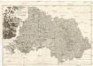
PROVINCIA REGINOHRADECENSIS et COMITATUS GLACENSIS
Hradec Králové-oblast (Česko) Bernardi, Augustin Augustin Bernardi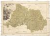
Provincia Reginohradecensis et comitatus Glacensis
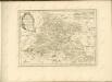
Kladsko-oblast (Polsko) Müller, Johann Christoph Winkler
Region Královehradecký
1 : 350000
Region Královehradecký
1 : 350000
Kriegsschauplatz Nordböhmen 1866
1 : 200000 Čechy severní (Česko) K. u. k. militär-geographisches Institut
Übersichtskarte der Aerarialstrassen, Eisenbahnen, dann der floss... in Böhmen
Charte ehemalinger Burgen u. Festen im Bidžower u Koeniggrätzer Kreise Böhmens

[Česko]
Česko
General-Karte des Königreiches Böhmen...

Kraj Hradecký
Území Východočeské elektrárny akc. spol. Hradec Králové II
1 : 200000 Čechy východní (Česko) Vojenský zeměpisný ústav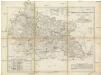
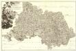
Karte des Bunzlauer- Jičiner- und Königgrätzer Kreises im oestreichischen Kronlande Boehmen
1 : 287000 Hradec Králové-oblast (Česko) Obentraut, Maxmilian Friedrich Kretzschmar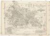
Karte des Bunzlauer- Jičiner- und Königgrätzer Kreises im oestreichischen Kronlande Boehmen
1 : 287000 Hradec Králové-oblast (Česko) Obentraut, Maxmilian Friedrich Kretzschmar
Hydrografische Uibersichtskarte der Flüsse, Bäche und sonstigen Gewässer im Königreiche Boehmen
[Nordostböhmen]
1 : 750000 Čechy severovýchodní (Česko)
Koenigreich Boehmen...

Königgrätz (Schweidnitz)
1 : 300000 Čechy východní (Česko) Hübl Frokr
A. Bidschover und B. Königingratzer Kreis samt der Grafschaft Glatz
1 : 200000 Hradec Králové-oblast (Česko) Peter Franza
A. Bidschover und B. Königingratzer Kreis samt der Grafschaft Glatz
1 : 200000 Hradec Králové-oblast (Česko) Peter Franza
Církevní mapa biskupství Králové-Hradeckého

Kraj hradecký

Spezial-Karte des Jičiner Kreis...
Provincia Reginohradecensis et Comitatus Glacensis
1 : 233000 Mollova mapová sbírka Erber, Bernardinus Winkler, Johann Christoph Kurzböck, Josef von