Maps of Germany

Sbírka map a diagramů použitých na mírových konferencích v Paříži v letech 1919 - 1920

Die Deutschen Bundesstaaten, das Kaiserthum Oesterreich, das Königreich Preussen, die Schweiz, das Kgr. Belgien, das Kgr. der Niederlande u. die angrenzenden Länder von 1792 bis zur Gegenwart
1 : 7350000 Mitteleuropa
Oesterreich in den Jahren 1564-1795
Evropa střední Gindely, Antonín F. Tempsky
Oesterreich im Jahre 1564, 1720, 1795.
Rakousko Benecke Bormann, E. F. Tempsky
Fluss- u. Gebirgs-Karte, Mittel-Europa.
1 : 4500000 Flemming, Carl
Deutschlands geschichtlich geographischer Zeitraum von 158 v. Chr. bis 260 n. Chr
Evropa střední Ehrenkreutz, I. V.
Nr. 8a. Die Germanisierung des Ostens
Ostmitteleuropa Deutsche, Siedlung
Carte élémentaire et statistique de l'Allemagne
1 : 2700000 Brion de La Tour, Louis Brion & Maire
R.A. Schulz's neue praktische Reise-Karte mit Angabe der Distanzen
Anglie Schulz, R. A. Biller, Dominik Artaria
Eisenbahn-Routen-Karte von Mittel-Europa
Evropa střední Ritter, Julius R. v. Waldheim
Central-Europa
Mitteleuropa
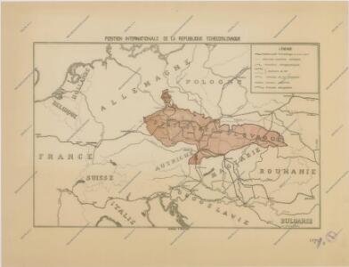
Sbírka map a diagramů použitých na mírových konferencích v Paříži v letech 1919 - 1920

Neue Ausgabe von Schulz's praktischer Reise-Karte mit Angabe der Distanzen und Eisenbahnen
Evropa střední Schulz, R. A. Artaria & Co.
Mitteleuropa am Ende des 30 jährigen Krieges
Evropa střední F. Tempsky
Geologische Übersichtskarte von Mittel-Europa
Evropa střední F. Tempsky
Mitteleuropa während des 30 jährigen Krieges.
Evropa střední Benecke Bormann, E. F. Tempsky
R.A. Schulz's neue praktische Reise-Karte mit Angabe der Distanzen
Evropa střední Schulz, R. A. Biller, Dominik Artaria & Co.
R.A. Schulz's neue praktische Reise-Karte mit Angabe der Distanzen
Evropa střední Schulz, R. A. Artaria & Co.
Sbírka map a diagramů použitých na mírových konferencích v Paříži v letech 1919 - 1920

Eisenbahnkarte von Mittel-Europa
1 : 2560000 Evropa střední
Postkarte durch ganz Deutschland, Italien, Frankreich, Niederland, Preussen, Polen und Ungarn
Florencie (Itálie) Mollo, Tranquillo T. Mollo
Prussia, and the German States.
from New general atlas.
Carte Politique de L'Europe Centrale.
1 : 3600000 Jouvet et Cie.
Geogr.-physik.-statist. Karte von Deutschland mit Einschluss von ganz Oesterreich, Belgien, den Niederlanden, der Schweiz, Italien und einem Theile von Frankreich, England, Russland und der Türkei
1 : 4110000 Evropa střední a východní Haurand Theobald Grieben
Grossdeutsches Reich und angrenzende Gebiete

Eisenbahn-Übersichtskarte von Mittel-Europa
Evropa R. v. Waldheim
Mitteleuropa: Konfessionsgebiete
1 : 9000000 Mitteleuropa Denomination
Europe Centrale.
1 : 4100000 Montemont, A.
Allemagne.
1 : 3300000 Lapie, M. (Pierre), 1779-1850