Maps of Germany

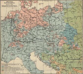
Mitteleuropa: Konfessionsgebiete
1 : 9000000 Mitteleuropa Denomination
Übersichtskarte der Staaten von Mitteleuropa

Oesterreich in den Jahren 1564-1795
Evropa střední Gindely, Antonín F. Tempsky
Oesterreich im Jahre 1564, 1720, 1795.
Rakousko Benecke Bormann, E. F. Tempsky
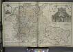
Geogr.-physik.-statist. Karte von Deutschland mit Einschluss von ganz Oesterreich, Belgien, den Niederlanden, der Schweiz, Italien und einem Theile von Frankreich, England, Russland und der Türkei
1 : 4110000 Evropa střední a východní Haurand Theobald Grieben
Völkerkarte von Mitteleuropa
1 : 9000000 Mitteleuropa Ethnische Gruppe
Post roads Germany, Hungary.
1 : 2500000 Robert Laurie & James Whittle
Mittel-Europäische Staaten
Stieler's Hand-Atlas Stieler, Adolf bei Justus Perthes
Carte élémentaire et statistique de l'Allemagne
1 : 2700000 Brion de La Tour, Louis Brion & Maire
Sbírka map a diagramů použitých na mírových konferencích v Paříži v letech 1919 - 1920

Habsburger Monarchie 1797 nach dem Frieden von Campo Formio
Österreich Friede von Campo Formio Kunz, Andreas ; Moeschl, Joachim Robert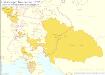
Habsburger Monarchie 1765, Toskana österreichische Sekundogenitur
Österreich, Toskana Kunz, Andreas ; Moeschl, Joachim Robert
Skelet zur Übersichtskarte von Mittel-Europa im Masse 1:750 000 und zur Hypsometrischen Karte der österr[isch-] ungar[ischen] Monarchie
1 : 750000 Rakousko-Uhersko R. Lechner
Central-Europa
Mitteleuropa
Die Deutschen Bundesstaaten, das Kaiserthum Oesterreich, das Königreich Preussen, die Schweiz, das Kgr. Belgien, das Kgr. der Niederlande u. die angrenzenden Länder von 1792 bis zur Gegenwart
1 : 7350000 Mitteleuropa
Karte der Heilquellen und Kurorte von Mittel - Europa

Neue Ausgabe von Schulz's praktischer Reise-Karte mit Angabe der Distanzen und Eisenbahnen
Evropa střední Schulz, R. A. Artaria & Co.
Volksdichtekarte von Mitteleuropa
1 : 9000000 Mitteleuropa Bevölkerungsdichte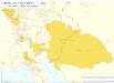
Habsburger Monarchie 1748 nach dem Frieden von Aachen
Österreich Kunz, Andreas ; Moeschl, Joachim Robert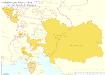
Habsburger Monarchie 1775 nach dem Erwerb der Bukowina
Österreich, Bukowina Kunz, Andreas ; Moeschl, Joachim Robert
Germania, Dacia.
1 : 13000000 Fenner, Rest.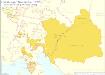
Habsburger Monarchie 1795 nach der dritten polnischen Teilung
Österreich Teilung Polens <1795> Kunz, Andreas ; Moeschl, Joachim Robert
Geogr.-physik.-statist. Karte von Deutschland mit Einschluss von ganz Oesterreich, Belgien, den Niederlanden, der Schweiz, Italien und einem Theile von Frankreich, England, Russland und der Türkei
1 : 4000000 Evropa střední Haurand, Theodor C. W.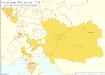
Habsburger Monarchie 1772 nach der ersten polnischen Teilung
Österreich, Teilung Polens <1772> Kunz, Andreas ; Moeschl, Joachim Robert
Sbírka map a diagramů použitých na mírových konferencích v Paříži v letech 1919 - 1920

Střední Evropa v době náboženské reformace a protireformace 1517 - 1648

Mittel-Europäische Staaten
Hand-Atlas über alle Theile der Erde nach dem neuesten Zustande und über das Weltgebäude Stieler, Adolf bei Justus Perthes
Mitteleuropa
1 : 8000000 Evropa střední Kocen, Blaž Eduard Hölzel
Österreich
1 : 7500000 Rakousko F. Tempsky