Maps of Smíchov

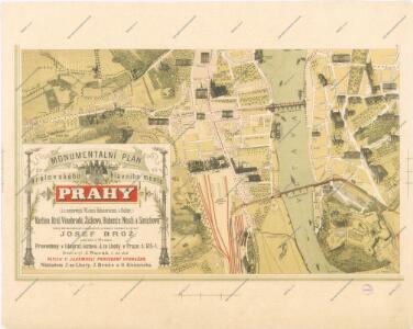
Monumentální plán královského města Prahy

Polohopisný plán Smíchova a Košíř
1 : 4000
Polohopisný plán Smíchova a Košířů

Polohopisný plán Smíchova a Košířů
1 : 4000 Košíře (Praha, Česko) Hurtig, Alfred F. Kytka
[Smíchov]
Smíchov (Praha, Česko)
Smíchov : předměstí král. hlavního města Prahy

Orientační plán Prahy a obcí sousedních List 15.
1 : 5000
Polohopisný plán královského hlavního města Prahy : 1.Staré město, 2.Nové město, 3.Malá strana, 4.Hradčany, 5.Josefov, 6.Vyšehrad pak Smíchova, Karlína, král.Vinohradů, Žižkova a Nuslí, s udáním starých i nových čísel domů
1 : 4000
Plan der Haupstadt Prag 18; 19

Praha. Mapy staré Prahy k letům 1200, 1348 a 1419

Hlavní město Praha...

Situationsplan des recht Moldauufers in Prag...

Grundriss der prädien Albertau, Henriettenau und Carlau
1 : 9000 Albertov (Praha, Česko) Kanjo, Michael Cosandier, Ferdinand
Abbildung deß weitberümbten Pragerischen allten Schlosses Wiserat, wie solches von ihr kayserl. und königl. May. Ferdi. III Ao. 1653 zu fortificiren angefangen, und von ihr kön. May. Leopoldo I. durch he. Obristen Joseph Priamii Freihe. von Rouorat, he. auf Lichna vollführet würt
Vyšehrad (Praha, Česko) Merian, Matthaeus M. Merian
Hlavní město Praha...

Situationsplan über die Parzelierung der böhm. Bau- und Immobilienbank gehörigen Baugründe
1 : 1440 Karlín (Praha, Česko)
Plan der Haupstadt Prag 18

Situations-Plan litt A. über den k. k. botanischen Garten am Smichov bei Prag sam[m]t allen darin befindlichen Gebauden
1 : 535 Smíchov (Praha, Česko)
Situationsplan des k. k. botanischen Gartens in Smichow
1 : 720 Smíchov (Praha, Česko)
Situations Plan der Gegend vor dem Augezder Thore zum Gebrauche bei der Beurtheilung der Distanzen
1 : 12600 Praha (Česko) Situations-Zeichnungs-Schule des k. k. G.F.M.L. Graf Kunigl 1.ten Feld-Artill. Regiments Schwihlik, Franz Situations-Zeichnungs-Schule des k. k. G.F.M.L. Graf Kunigl 1.ten Feld-Artill. Regiments
Prag - c6068-1-002 - Kaiserpflichtexemplar der Landkarten des stabilen Katasters
1 : 2880
Prag - c6068-1-006 - Kaiserpflichtexemplar der Landkarten des stabilen Katasters
1 : 2880
Prag - c6068-1-003 - Kaiserpflichtexemplar der Landkarten des stabilen Katasters
1 : 2880
Prag - c6068-1-001 - Kaiserpflichtexemplar der Landkarten des stabilen Katasters
1 : 2880
Prag - c6068-1-004 - Kaiserpflichtexemplar der Landkarten des stabilen Katasters
1 : 2880
Prag - c6068-1-005 - Kaiserpflichtexemplar der Landkarten des stabilen Katasters
1 : 2880
PLAN DE PRAG
1 : 8000 Praha (Česko) Bailleul, Nicolas chez Bailleul le jeune
Praha : názorné plány a rejstřík