Maps of Ústecký kraj

Karte des Saazer Kreises im Koenigreiche Boehmen
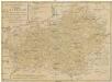
Karte der nordwestlichen Theiles von Böhmen
1 : 229000 Františkovy Lázně (Česko) k. k. Direction der administrativen Statistik
Mittelbach's Strassenprofilkarte des Gebietes der böhmischer Bäder und des Erzgebirges für Rad- und Motorfahrer
1 : 300000 Krušné hory (Česko a Německo) Mittelbach's Verlag
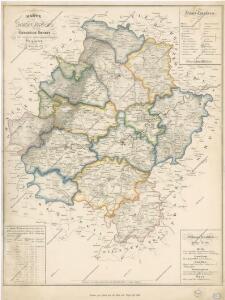
Special-Karte des Saazer Kreises
1 : 210000 Žatec-oblast (Louny, Česko) Schmidt, Eduard C.W. Medau
Special-Karte des Saazer Kreises
1 : 210000 Žatec-oblast (Louny, Česko) Schmidt, Eduard C.W. Medau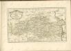

Special-Karte des Saazer Kreis, resp. polit. Verwaltungsbezires nach der politischen Eintheilung Böhmens v. Jah. 1868
1 : 220000 Žatec-oblast (Louny, Česko) Schmidt, Eduard Wend. Morauer
Special-Karte des Saazer Kreis - resp. politischen Verwaltungsbezirkes
1 : 220000 Žatec-oblast (Louny, Česko) Schmidt, Eduard W. Morauer
Geognostisch-Montanistische Übersichts-Karte des Egerer Handelskammer-Gebietes
1 : 290000 Cheb-oblast (Česko) Hickmann, Anton L. Egerer Handelskammer
Übersichts-Karte der bedeutendsten Industrial-Unternehmungen nebst Angabe des Waldterrains
1 : 290000 Cheb-oblast (Česko) Hickmann, Anton L. Egerer Handelskammer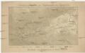
Orientirungskartchen zur Hydrographie des Egergebietes
Krušné hory (Česko a Německo)
Charte vom Saatzer Kreise des Königreichs Böheim
1 : 240000 Žatec-oblast (Louny, Česko) Kreibich, František Jakub Jindřich C. W. Enders
Charte vom Saatzer Kreise des Königreichs Böheim
1 : 240000 Žatec-oblast (Louny, Česko) Kreibich, František Jakub Jindřich Enders, C. W. C.W. Enders
Charte vom Saatzer Kreise des Königreichs Böheim
1 : 240000 Žatec-oblast (Louny, Česko) Kreibich, František Jakub Jindřich Enders, C. W. C.W. Enders
Charte vom Saatzer Kreise des Königreichs Böheim
1 : 240000 Žatec-oblast (Louny, Česko) Kreibich, František Jakub Jindřich Enders, C. W. C.W. Enders
Charte vom Saatzer Kreise des Königreichs Böheim
1 : 240000 Žatec-oblast (Louny, Česko) Kreibich, František Jakub Jindřich Enders, C. W. C.W. Enders
Charte vom Saatzer Kreise des Königreichs Böheim
1 : 240000 Žatec-oblast (Louny, Česko) Kreibich, František Jakub Jindřich Rainold, Karl Eduard C.E. Rainold
Charte vom Saatzer Kreise des Königreichs Böheim
1 : 240000 Žatec-oblast (Louny, Česko) Kreibich, František Jakub Jindřich Rainold, Karl Eduard C.E. Rainold
Charte vom Saatzer Kreise des Königreichs Böheim
1 : 240000 Žatec-oblast (Louny, Česko) Kreibich, František Jakub Jindřich C. E. Rainold
Charte vom Saatzer Kreise des Königreichs Böheim
1 : 240000 Žatec-oblast (Louny, Česko) Kreibich, František Jakub Jindřich Rainold, Karl Eduard C.E. Rainold
Charte vom Saatzer Kreise des Königreichs Böheim
1 : 240000 Žatec-oblast (Louny, Česko) Kreibich, František Jakub Jindřich Rainold, Karl Eduard C.E. Rainold
Charte vom Saatzer Kreise des Königreichs Böheim
1 : 240000 Žatec-oblast (Louny, Česko) Kreibich, František Jakub Jindřich C. E. Rainold
Charte vom Saatzer Kreise des Königreichs Böheim
1 : 240000 Žatec-oblast (Louny, Česko) Kreibich, František Jakub Jindřich Rainold, Karl Eduard C.E. Rainold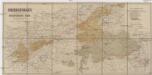
Uibersichtskarte der a. p. Buschtěhrader Bahn (Böhm. Nordwestbahn)
1 : 288000 Buštěhradská dráha (Česko : zaniklá železniční trať) Dobrohlaw, Johann Johann Dobrohlaw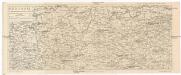
Rudohoří
1 : 288000 Krušné hory-oblast (Česko a Německo) Líčka, Josef Smrček, Antonín nákladem Františka Řivnáče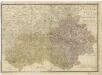
Elbogner dan Saatzer Kreis und Egerische = Gebiet
Regni Bohemiae circulus Satecensis
1 : 220000 Žatec-oblast (Louny, Česko) Müller, Johann Christoph editus curis Homannianorum Heredum
Regni Bohemiae circulus Satecensis
1 : 220000 Žatec-oblast (Louny, Česko) Müller, Johann Christoph editus curis Homannianorum Heredum
Regni Bohemiae circulus Satecensis
1 : 220000 Žatec-oblast (Louny, Česko) Müller, Johann Christoph editus curis Homannianorum Heredum