Maps of Camden

London VI.20 - OS London Town Plan
1 : 1056 Topographic maps Ordnance Survey Ordnance Survey
London (1915- Numbered sheets) IV.4 (includes: Hampstead; St Marylebone) - 25 Inch Map
1 : 2500 Topographic maps Ordnance Survey Ordnance Survey
London (1915- Numbered sheets) IV.4 (includes: Hampstead; St Marylebone) - 25 Inch Map
1 : 2500 Topographic maps Ordnance Survey Ordnance Survey
London (First Editions c1850s) XV (includes: Hampstead; St Marylebone) - 25 Inch Map
1 : 2500 Topographic maps Ordnance Survey Ordnance Survey
THE REGENT'S PARK
1 : 4800 This plan was commissioned by the House of Commons and issued as a supplement to the Wood, Forests and Land Revenues report. The plan's title and imprint are at top right, with a scale bar and key at bottom right. The part of the park to be opened to the public is shown in pale yellow. The grounds of the Zoological Society and the Royal Botanic Society are shown in pink. The areas to be fenced off to protect the privacy of the local residents are shown in dark green. The land to the north of the park recently acquired by Eton College is shown in pale green, and that acquired by Lord Southampton, in pink. Basire, James
A PLAN for the improvements of a FREEHOLD ESTATE call'd ST. IOHN'S WOOD situated in the Parishes of MARYLEBONE & HAMPSTEAD propos'd by Spurrier & Phipps
1 : 7380 The title of this plan of proposed residential developments at St. John's Wood, appears in a tablet at bottom left. A key to the dimensions of lots appears in a tablet at bottom right, with scale noted at the foot of the plate. The revolutionary layout of the estate included a grand circus (never built) surrounded by semi-detatched properties. Spurrier & Phipps
London VI.NE - OS Six-Inch Map
1 : 10560 Topographic maps Ordnance Survey Ordnance Survey
PLAN of the several Freehold Estates situated on the North side of the New Road within the Parish of St. Mary-le-bone and Parts of Hampstead and St. Pancras in the County of Middlesex
1 : 1584 This is Crace's own copy of an 18th-Century plan of the estates north of the New Road at Marylebone. The title and scale bar feature at bottom left, with compass at top centre, and descriptive notes at top left and down the right margin of the sheet. Outline colour marks the boundaries of estates and a single black line those of fields within the estate. The plan also reports the names of landlords and tenant occupiers, with key to the dimensions of each field and estate in a table above the plan. Jones, John
Charles Booth's descriptive map of London poverty 1889
Charles Booth
PLAN OF THE PARISH OF ST. MARYLEBONE with the Improvements proposed ON THE MARYLEBONE PARK ESTATE WITH THE CONTIGUOUS PARTS of the Parish of St. Pancras
1 : 5333 Plan of the Parish of St. Marylebone with title at bottom left and explanatory note at bottom right describing proposals for building houses and gardens on land belonging to the Crown along the New Road. White, John
London NW.
1 : 15840 Stanford, Edward
Insurance Plan of London Vol. xi: Key Plan 1
1 : 3600 This "key plan" indicates coverage of the Goad 1891 series of fire insurance maps of London that were originally produced to aid insurance companies in assessing fire risks. The building footprints, their use (commercial, residential, educational, etc.), the number of floors and the height of the building, as well as construction materials (and thus risk of burning) and special fire hazards (chemicals, kilns, ovens) were documented in order to estimate premiums. Names of individual businesses, property lines, and addresses were also often recorded. Together these maps provide a rich historical shapshot of the commercial activity and urban landscape of towns and cities at the time. The British Library holds a comprehensive collection of fire insurance plans produced by the London-based firm Charles E. Goad Ltd. dating back to 1885. These plans were made for most important towns and cities of the British Isles at the scales of 1:480 (1 inch to 40 feet), as well as many foreign towns at 1:600 (1 inch to 50 feet). Chas E Goad Limited Chas E Goad Limited
Insurance Plan of London West North-West District Vol. B: Key Plan
1 : 3600 This "key plan" indicates coverage of the Goad 1902 series of fire insurance maps of London that were originally produced to aid insurance companies in assessing fire risks. The building footprints, their use (commercial, residential, educational, etc.), the number of floors and the height of the building, as well as construction materials (and thus risk of burning) and special fire hazards (chemicals, kilns, ovens) were documented in order to estimate premiums. Names of individual businesses, property lines, and addresses were also often recorded. Together these maps provide a rich historical shapshot of the commercial activity and urban landscape of towns and cities at the time. The British Library holds a comprehensive collection of fire insurance plans produced by the London-based firm Charles E. Goad Ltd. dating back to 1885. These plans were made for most important towns and cities of the British Isles at the scales of 1:480 (1 inch to 40 feet), as well as many foreign towns at 1:600 (1 inch to 50 feet). Chas E Goad Limited Chas E Goad Limited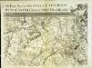
An exact survey of the city's of London Westminster , XII
1 Blatt : 53 x 72 cm John Rocque
An exact survey of the city's of London Westminster , XI
1 Blatt : 53 x 71 cm John Rocque
London
Grosser Hand-Atlas über alle Theile der Erde in 170 Karten Meyer, J. Verlag des Bibliographischen Instituts
London Sheet J - OS Six-Inch Map
1 : 10560 Topographic maps Ordnance Survey Ordnance Survey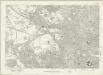
London Sheet J - OS Six-Inch Map
1 : 10560 Topographic maps Ordnance Survey Ordnance Survey
Middlesex XVI - OS Six-Inch Map
1 : 10560 Topographic maps Ordnance Survey Ordnance Survey
A New plan of LONDON and WESTMINSTER
The publisher's imprint of this folding map appears below the plan, with squares, open spaces, and the built-up area in the city distinguished from each other by colour. The map also shows the Regents Canal from Paddington to Shoreditch. Title and date are featured in the original slip case for the map, but don't appear on the map itself. Wallis, Edward
LONDINUM, LONDON
This small map possibly derives from a German work published in Nuremberg.
PAYNE'S IMPROVED PLAN OF LONDON
The title of this map appears at top right alongside the publisher’s imprint (in shield) and the city arms. The map is divided in half-mile squares with letters and numbers for reference running along the borders. It shows the Dover, Croydon, Greenwich, Blackwall, Eastern, North London, Great Northern and Birmingham railway lines and their termini. Payne, Albert Henry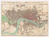
The stranger's guide to London and Westminster exhibiting all the various alterations and improvements, complete to the present time
Mogg, Edward Edward Mogg
Map shewing the situation of all premises licensed for the sale of intoxicating liquors in the County of London
London County Council
London at a View: a New Map
A copy of Bigg's map of London of 1842 lacking the title, the views and the note at the bottom of the map. The map features scale bar and compass rose at top left with main roads in yellow, water courses in blue, parks and open spaces in green and railways in red. Biggs, George
CARY'S New and Accurate Plan of LONDON, WESTMINSTER, the Borough of SOUTHWARK and parts adjacent
John Cary was possibly the most productive English map maker and publisher of the18th Century. His works were reissued many times, but unlike many of his contemporaries he aimed to update each edition by showing new developments. This is the third edition of a map first published in 1787. The developments in Somers Town are shown; the Lambeth and London roads are named. The numerous parks and gardens across the city are coloured green. The map is divided into squares, numbered for reference. Cary, John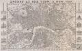
LONDON AT ONE VIEW: A NEW MAP
Map of London with title along the top, scale bar at top left and statistical note below the map. Down both sides of the map are views of London prominent buildings and landmarks. Nelson Column, Westminster Hall, Horse Guard, Buckingham Palace and Burlington Arcade are depicted down the left of the map and the Monument, St Paul's Cathedral, Guildhall, the Royal Exchange, Temple Bar and the Thames Tunnel down the right. Biggs, George
LONDON 270
This map of Victorian London was published in the 'Weekly Dispatch' newspaper of 1756. Its title appears at top right, along with the publisher’s imprint and scale bar. Based on Davies's map of 1847, the map shows London railway termini, the South Western, West London and North Kent lines, and all post-receiving houses and pillars. Cassell, Petter & Calpin
THE RAILWAY BELL AND THE ILLUSTRATED LONDON ADVERTISER MAP OF LONDON
This is a special edition of Biggs's map of London of 1842 for subscriber to the Illustrated London Advertiser. The map features title at the top superimposed to a view of the Thames at St Paul's and views of public buildings down both sides and along the bottom of the plan, with portraits of Queen Victoria and Prince Albert at bottom centre. Biggs, George


