Maps of Germany

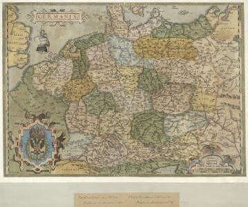
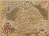
Germania
1 : 3100000 Mollova mapová sbírka Ortelius, Abraham
L'Empire d'Allemagne distingué suivant l'étendüe de tous les Estats, Principautés et Souverainetés qui passent ou qui ont passé jusque a present sous le nom d'Allemagne
1 : 2100000 Mollova mapová sbírka Sanson, Guillaume Covens, Johannes I
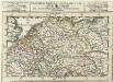
L'empire d'Allemagne
1 : 2600000 Evropa střední Sanson, Guillaume Cordier, Louis chez H. Iaillot
L'Allemagne.
1 : 2500000 L'Isle, Guillaume de, 1675-1726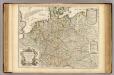
L'Allemagne.
1 : 2500000 L'Isle, Guillaume de, 1675-1726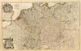
Composite: L'Alemagne.
1 : 1800000 Rizzi Zannoni, Giovanni Antonio Bartolomeo, 1736-1814
L'Empire d'Allemagne
Mollova mapová sbírka Fer, Nicolas de Danet, Guillaume
Post Charte der Östereichis = Teutschen, Preussischen u. Teut. Bund. Staaten...
S. Imperium Romano-Germanicum =
1 : 9500000 Mollova mapová sbírka Bodenehr, Gabriel Bodenehr, Gabriel
L' Empire D'Allemagne [...] [Karte], in: Atlas nouveau, contenant toutes les parties du monde [...], Bd. 1, S. 161.
1 Karte aus Atlas Sanson, Nicolas Jaillot, Alexis Hubert und Mortier, Pieter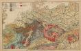
Geologie. II. Mitteleuropa
1 : 3500000 Europa Geologie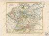
General Karte von Deutschland

Post- und Reise-Charte von Deutschland und den benachbarten Laendern / nach den neuesten Quellen entw. von C.F. Weiland ; C.J. Maedel sculps.
1 : 1500000 Annotatie geografische gegevens: Grenzen gekleurd Weiland, C. F.; Maedel, C. J. Weimar : Geogr. Institut
Germania [Karte], in: Gerardi Mercatoris Atlas, sive, Cosmographicae meditationes de fabrica mundi et fabricati figura, S. 327.
1 Karte aus Atlas Mercator, Gerhard Montanus, Petrus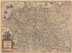
Germaniae nova et accurata delineatio [Karte], in: Novus atlas absolutissimus, Bd. 2, S. 13.
1 Karte aus Atlas Janssonius Offizin
[Deutschland, Niederlande, Belgien und Schweiz; National-, Sprach-, Dialect- Verschiedenheit]
Zweiter Band, enthaltend in vier Abtheilungen die Vertheilung der Organismen: 5. Pflanzen-Geographie, 6. Thier-Geographie, 7. Anthropographie, 8. Ethnographie Humboldt, Alexander von Verlag von Justus Perthes
Post- und Reisekarte von Deutschland, den Niederlanden, Belgien und der Schweiz
1 : 2470000 Belgie Bachmann, Friedrich Nast Friedr. Kornschen Buchhandlung
Post- und Reisekarte von Deutschland, den Niederlanden, Belgien und der Schweiz
1 : 2470000 Belgie Bachmann, Friedrich Nast Friedr. Kornschen Buchhandlung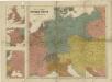
Prof. W. Liebenow's Kriegskarte von Mitteleuropa

Geschäfts- und Reise-Karte von Deutschland und den angrenzenden Ländern
Evropa střední Koenig, Theophil R. Drawert
Post- und Eisenbahnkarte von Deutschland und den benachbarten Laendern
1 : 2450000 Evropa střední Weiland, Karl Ferdinand Mädel, C. J. Geograph. Institut
Nieuwe kaart van Duitschland, opgemaakt volgens de naukeurigste waarneemingen
1 : 7250000 [S.l.] : [s.n.]
Germaniae Typus. [Karte], in: Theatrum orbis terrarum, S. 159.
1 Karte aus Atlas Ortelius, Abraham Vrients, Jan Baptista
Post und Reisekartre von Deutschland...
Germania. [Karte], in: Theatrum orbis terrarum, S. 40.
1 Karte aus Atlas Ortelius, Abraham
Post- und Reisekarte von Deutschland, den Niederlanden, Belgien und der Schweiz, nebst Theilen der angrenzenden Länder bis London, Havre de Grace, Turin, Warschau, Kopenhagen
1 : 2500000 Bachmann, Fr. Verlag der Friedrich Kornschen Buchhandlung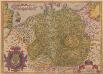
Germania. [Karte], in: Theatrum orbis terrarum, S. 102.
1 Karte aus Atlas Ortelius, Abraham
Übersicht der Schnellpost und Eilwagen, ... Deutschland

Reisekarte von Deutschland und den angrenzenden Ländern
Evropa střední Mahlmann, H. Morin, F. H. F.H. Morin