Maps of Bad Mitterndorf
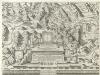
Archiducatus Austriae Superioris Geographica Descriptio. facta Anno 1667
1 : 150000 Mollova mapová sbírka Vischer, Georg Matthaeus Küssel, Melchior
Liezen.
from Spezialkarte der osterreichisch-ungarischen Monarchie.
Zone 15, Col. X, Liezen, uit: Geologische Karte der im Reichsrathe vertretenen Königreiche und Länder der Österreich-Ungarischen Monarchie : auf Grundlage der Specialkarte i.M. 1:75.000 des k.u.k. Militär-geographischen Institutes / neu bearb. und als Kartenwerk von 341 Blattnummern in zwanglosen Lfg. hrsg. durch die k.k. Geologische Reichsanstalt in Wien
1 : 75000 titelvariant: Geologische Spezialkarte der im Reichsrate vertretenen Königreiche und Länder der Österreichisch-Ungarischen Monarchie; Geologische Specialkarte der im Reichsrathe vertretenen Königreiche und Länder der Österreichisch-Ungarischen Monarchie; Annotatie: Titel bovenaan kaartblad: Geologische Spezialkarte der im Reichsrate vertretenen Königreiche und Länder der Österreichisch-Ungarischen Monarchie en Geologische Specialkarte der im Reichsrathe vertretenen Königreiche und Länder der Österreichisch-Ungarischen Monarchie; Annotatie geografische gegevens: Coördinaten gebaseerd op nulmeridiaan van Ferro (Hierro) Kaiserlich-Königliche Geologische Reichsanstalt, Wenen Wien : K.K. Geologische Reichsanstalt
Bad Aussee
1 : 25000 Hauptvermessungsabteilung XIV
Speikberg
1 : 25000 Hauptvermessungsabteilung XIV
Atlas der österreichischen Alpenseen

Speikberg
1 : 25000 Kartographisches Institut
Altaussee
1 : 25000 Altaussee (Rakousko) Kartographisches Institut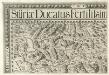
Stÿriae Ducatus Fertilisimi Nova Geographica Descriptio
1 : 200000 Mollova mapová sbírka Vischer, Georg Matthaeus Trost, Andreas
Grobming und St. Nicolai.
from Spezialkarte der osterreichisch-ungarischen Monarchie.
Karte des Salzkammergutes
1 : 75000 Solná komora (Rakousko) R. Lechner
Karte des Salzkammergutes
1 : 75000 Solná komora (Rakousko) R. Lechner
Reliefkarte des Salzkammergutes
1 : 100000 Solná komora (Rakousko) Pelikan, Gustav Edler von Gustav Edl. von Pelikan
Karte der Dachsteingruppe
1 : 25000 Dachstein (Salcburské Alpy, Rakousko : pohoří)
Lahn
1 : 25000 Kartographisches Institut
Lauffen
1 : 25000 Hauptvermessungsabteilung XIV
Lauffen
1 : 25000 Hauptvermessungsabteilung XIV
Reisekarte des Salzkammergutes und der angrenzenden Gebiete
1 : 100000 Solná komora (Rakousko) Mally, Em. Section Austria
Carte topographique d'Allemagne contenant une partie de l'Autriche superieur [et] du duche de Stirie [et]c
1 Karte : Kupferdruck ; 45 x 63 cm Jaeger Jäger
Murau 159, uit: Special-Karte von Mittel-Europa / nach amtlichen Quellen bearbeitet von W. Liebenow
1 : 300000 titelvariant: W. Liebenow's Mittel-Europa; Annotatie: Titel boven de bladen: W. Liebenow's Mittel-Europa Johannes Wilhelm Liebenow 1822-1897 Frankfurt a. M. : Ludwig Ravenstein
Militair Karte von Süd-Deutschland in 20 Sectionen
1 : 400000 16. Section Coulon, Alois von A. von Coulon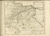

[Fol. IV]
1 Karte : 43 x 55 cm Königliche Akademie der Wissenschaften
Der westliche Theil von Obersteyermark oder der Judenburger Kreis
1 : 250000 Horní Rakousko (Rakousko) Kindermann, Joseph Karl Junker, Christoph Franz Xaver Miller
Archiducatus Austriae Superioris. Ober Österreich
1 : 550000 Mollova mapová sbírka Suttinger, Johann Baptist Merian, Matthäus
Plan des Bergwergs Nabloch und Hirn
Mollova mapová sbírka Geyer
Generalkarte von Zentraleuropa

Das Herzogthum Ober und Nieder Baiern, 4
1 Karte : 43 x 55 cm Lotter
Archiducatus Austriae superioris in suas quadrantes ditiones exacte divisi accuratissima tabula
1 : 340000 Rakousko Homann, Johann Baptist Vischer, Georg Matthaeus J. B. Homann
Archiducatus Austriae superioris in suas quadrantes ditiones exacte divisi accuratissima tabula
1 : 340000 Rakousko Homann, Johann Baptist Vischer, Georg Matthaeus Johann Baptist Homann
Archiducatus Austriae superioris in suas quadrantes ditiones exacte divisi accuratissima tabula
1 : 340000 Rakousko Vischer, Georg Matthaeus Homann, Johann Baptist Johann Baptist Homann
Archiducatus Austriae superioris in suas quadrantes ditiones exacte divisi accuratissima tabula
1 : 340000 Rakousko Vischer, Georg Matthaeus Homann, Johann Baptist Johann Baptist Homann
Archiducatus Austriae superioris in suas quadrantes ditiones exacte divisi accuratissima tabula
1 : 350000 Rakousko Homann, Johann Baptist Vischer, Georg Matthaeus a Ioh. Baptista Homanno


