Maps of South West England

Regnum Bohemiae eique annexae Provinciae ut Ducatus Silesiae Marchionatus Moraviae et Lusatiae Vulgo Die Erb-Landeren
1 : 945000 Mollova mapová sbírka Visscher, Nicolaes Jansz.
Saxonia Svperior, Cvm Lvsatia et Misnia
1 : 780000 Mollova mapová sbírka Blaeu, Joan Blaeu, Joan I.
Ober Sachsen Laußnitz vnd Meissen
1 : 1200000 Mollova mapová sbírka Merian, Matthaeus Merian, Matthäus
Operationum bellicarum in Germania ulterior Repraesentatio
1 : 700000 Mollova mapová sbírka Rizzi Zannoni, Giovanni Antonio Homann, Johann Baptista - dědici
58 Roermond, uit: Topographische en militaire kaart van het Koningrijk der Nederlanden / vervaardigd door de officieren van den Generale Staf ; en gegraveerd op het Topographisch Bureau, van het Ministerie van Oorlog
1 : 50000 titelvariant: TMK; Annotatie: Met bladwijzer op schaal 1:600.000. - 1915; Met Verklaring van de topographische en militaire kaart van het Koninkrijk der Nederlanden. - 1910; Bd. 1: titelblad, bladwijzer, verklaring, bladen 1 t/m 32; Bd. 2: bladen 33 t/m 62 Generale Staf, Nederland; Ministerie van Oorlog. Topographisch Bureau ['s-Gravenhage : Ministerie van Oorlog]
Militair- Commerzial- und Post-Strassen von Dresden nach Warschau
Drážďany (Německo)
Militair- Commerzial- und Post-Strassen von Dresden nach Warschau
Drážďany (Německo)
De Cust van Zeeland : Begrypende in sich de Zee gaten, als van de Wielingen. Ter Veere. Zieric zee. Brouwers-haven. Goeree en de Maes
1 : 160000 Theunisz, Jacob Amsterdam : Lootsman, Jacob Theunisz
Carta generale de Paesi Bassi terzo foglio che comprende la Contea di Zelanda, porzione di quella di Olanda, la Contea di Flandria, parte del Ducato di Brabante, il Marchesato d'Anversa, e la Signoria di Malines
1 : 570000 Gio. Ma. Cassini Som. inc. Roma : presso la Calcografia Camerale
Circulus Saxoniae Superioris
1 : 480000 Mollova mapová sbírka Valk, Gerhard Valck, Gerard
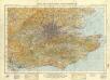
General Map (London Environs).
Cary, John
Ducatus Saxoniae Superioris :
1 : 720000 Mollova mapová sbírka Zollmann, Friedrich Homann, Johann Baptista - dědici
Friderico Augusto vere Augusto Polon. Lithuan. Borus. Pomer. Regi, Duci, Principi, Saxon. Utr. Duci S. Imp. Elect. Haec. Imperii Sui Regna D.D.D.
1 : 3100000 Mollova mapová sbírka Schenk, Pieter Schenk, Peter I
Hanc Regni Poloniarvm Magniqve Dvcatvs Lithvaniae Rvssiae, Prvssiae, Mazoviae, Samogitiae, Kioviae, Volhyniae, Podoliae, Podlachiae, Livoniae, Smolensci, Severia e. Czern.
1 : 3000000 Mollova mapová sbírka Homann, Johann Baptist Homann, Johann Baptista - dědici
Grundriß der Schlesischen Hauptstadt Bresslau, nebst einer genauen Landkarte welche die umliegende Gegend auf einige Meilen anzeigt
1 : 140000 Mollova mapová sbírka Trattner, Johann Thomas von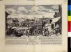
Vorstellung der Bataille bei Crevelt in dem Fürstenthum Meurs, allwo die Aliirte Armée unter Commando Sr. Hochfürstl. Durchl. des Herzogs Ferdinands von Braunschweig den 23. Junii 1758. einen herrlichen Sieg über die Französische Armee erfochten
England and Wales 1:253,440
Ordnance Survey
Bassin de la Tamise : et bassins secondaires du Blackwater, du Stour et du versant de la Manche
1 : 600000 Vuillemin, Alexandre Aimé 1812-1880 Paris : Imprimerie et librairie Delalain
Bartholomew's "Quarter to mile" road map of the environs of London
1 : 25000 Hugh Rees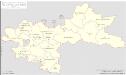
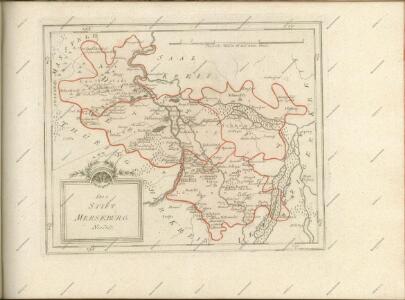
Regierungsbezirk Merseburg Kreiseinteilung 1820
Preußen, Merseburg, Regierungsbezirk Kunz, Andreas ; Johnen, Bettina ; Moeschl, Joachim
[Kaart], uit: Sachsen-Mitteldeutschland
1 : 470000 Annotatie: Verso: afstandstabel [S.l. : Shell Reisedienst]
Flandria et Zeelandia comitatvs
1 : 350000 Flandry Blaeu, Willem Janszoon apud Guiljelmum Blaeuw
[49][49] Hassia Landgraviatus, uit: Atlas sive Descriptio terrarum orbis
Annotatie: Gedigitaliseerde versie. Amsterdam. Heiloo : Picturae (vervaardiger), 2015. tiff-bestand. Gedigitaliseerd: 07-01-2015; Origineel: Universiteitsbibliotheek Vrije Universiteit (XL.05127.-) ; Netherlands; Titelpagina ontbreekt Wit, Frederik de Amsterdam : Frederick de Wit
delineation of the strata of England and Wales, with part of Scotland
1 : 320000 Blatt 10 Smith, William Cary
Pars I Frisiae haereditariae cis Mosam quae Wasda, nunc Zelandia, una cum provincialib. VII Foederator ultra citraque Scaldim et Mosam sub Ottonibus potissimum
1 : 490000 auctore Mensone Alting G. de Broen fecit ... [Amstelaedami] : [apud Henricum Wetstenium]
Nouvelle carte de la province de Zélande
1 : 115000 dressée et gravée par C. van Baarsel et fils. A La Haye : chez F.J. Weygand, marchand de cartes-geographiques de S.M. le Roi des Pays-Bas
Bravnswyck et Meydbvrg cum terris adjacentibus
1 : 690000 Mollova mapová sbírka Hamersveldt, Everard S. van Rogiers, Salomon Janssonius, Johannes I
Misniae et Lvsatiae Tabvla
1 : 1200000 Mollova mapová sbírka Scultetus, Bartholomaeus