Maps of Flemish Region

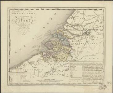
Nouvelle carte de la province de Zélande
1 : 115000 dressée et gravée par C. van Baarsel et fils. A La Haye : chez F.J. Weygand, marchand de cartes-geographiques de S.M. le Roi des Pays-Bas
Carta generale de Paesi Bassi terzo foglio che comprende la Contea di Zelanda, porzione di quella di Olanda, la Contea di Flandria, parte del Ducato di Brabante, il Marchesato d'Anversa, e la Signoria di Malines
1 : 570000 Gio. Ma. Cassini Som. inc. Roma : presso la Calcografia Camerale
Zelandiae typus.
1 : 420000 [Amsterdam] : [Willem Jansz. Blaeu]
Kaart der overstroomingen in het Koningrijk der Nederlanden op de 3, 4, 5 en 6 Februarij 1825 : zuidelijk gedeelte.
1 : 450000 ['s-Gravenhage] : [J. Immerzeel jr.]
Polder Langeland en Kortland, gemeente Krimpen a/d IJssel.
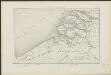
Ausfluss der Schelde in die Nord-See
1 : 500000 Nizozemsko Adam, Jakob Artaria
Ausfluss der Schelde in die Nord-See
1 : 500000 Nizozemsko Adam, Jakob Artaria Comp.
Comitatus Zeelandiae novissima descriptio
1 : 220000 auct. Petrum Verbist. Antverpiae : apud Petrum Verbist sub signo Americae in platea quae vulgo Lombardorum moenia dictur
A new map of Zealand : with the rivers Schelde, part of Holland, Flanders & Brabant, shewing the situation of the present dispute between the Emperor and the Dutch.
1 : 245000 London : Jno. Stockdale Picadilly
Pars I Frisiae haereditariae cis Mosam quae Wasda, nunc Zelandia, una cum provincialib. VII Foederator ultra citraque Scaldim et Mosam sub Ottonibus potissimum
1 : 490000 auctore Mensone Alting G. de Broen fecit ... [Amstelaedami] : [apud Henricum Wetstenium]
Flandria et Zeelandia comitatvs
1 : 350000 Flandry Blaeu, Willem Janszoon apud Guiljelmum Blaeuw
[Belgie a Nizozemí]
Belgie Schraembl, Franz Anton F.A. Schraembl
A new map of Zealand : with the rivers Schelde, part of Holland, Flanders & Brabant, shewing the situation of the Schelde.
1 : 245000 London : Jno. Stockdale Picadilly
Neuer Plan von den Lauf der Schiffbaren Schelde von Antwerpen durch Holländisch Seeland, bis zu deren Mündung an der Nord-See
1 : 550000 I. Berlia sc. Prag : aus der von Schönfeldischen Officin
Zeelandia Comitatus. [Karte], in: Le théâtre du monde, ou, Nouvel atlas contenant les chartes et descriptions de tous les païs de la terre, Bd. 1, S. 436.
1 Karte aus Atlas Blaeu, Willem Janszoon und Blaeu, Joan Blaeu, Willem Janszoon
Zeelandia Comitatus. [Karte], in: Novus Atlas, das ist, Weltbeschreibung, Bd. 1, S. 405.
1 Karte aus Atlas Blaeu, Joan Blaeu, Willem Janszoon
Abris der Schelde, soweit sie schiffbar ist, von Antwerpen bis an die Nord-See
1 : 550000 Math. Pock geometra sc. Salisburgi. Salzburg : Lor. Hübner
Zeelandia Comitatus. [Karte], in: Theatrum orbis terrarum, sive, Atlas novus, Bd. 1, S. 437.
1 Karte aus Atlas Blaeu, Joan Blaeu, Willem Janszoon
Zeelandia Comitauts. [Karte], in: Novus atlas absolutissimus, Bd. 3, S. 188.
1 Karte aus Atlas Janssonius Offizin
Zeelandia Comitatus. [Karte], in: Gerardi Mercatoris et I. Hondii Newer Atlas, oder, Grosses Weltbuch, Bd. 1, S. 459.
1 Karte aus Atlas Mercator, Gerhard und Hondius, Jodocus Jansson, Jan
Carte des bouches de l'Escaut
1 : 500000 dressée par Th. Duvotenay gravée par Ch. Dyonnet. Paris : Lheureux et Cie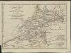
Esquisse géographique du cours de l'Escaut d'Anvers à la mer, de ses bouches, et de ses communications avec l'intérieur de la Flandre, de la Zelande et de la Hollande : Les Isles de Walcheren, Wolfertsdyk etc]
1 : 510000 par L.S. de La Rochette gravé par J. Turpin à La Haye. [London] : [Faden]
Zeelandia comitatus
1 : 270000 Cornelis Danckerts excudit. [Amsterdam] : Cornelis Danckerts excudit
Zeelandia Comitatus
1 : 700000 Petrus Kaerius Flander caelavit aetatis 75. [Amsterdam] : [Johannes Janssonius]
Zelandicarum insularum exactissima et nova descriptio
1 : 540000 auctore D. Jacobo à Daventria Johan Bussemecher excudit ; Henricus Nagell fecit. [Coln am Rhein] : [Buxemacher]
De Zee-kusten van Zeelandt, begrijpende de gaten als van de Wielingen, ter Veere, Zierickzee, Brouwershaven, en Goeree.
from De zee-atlas ofte water-wereld : waer in vertoont werden alle de zee-kusten van het bekende des aerd-bodems : seer dienstigh voor alle heeren en kooplieden, als oock voor alle schippers en stuurlieden / by Pieter Goos.
Zeeland
1 : 790000 P.H. Witkamp del. D. Veelwaard sculps. Amsterdam : C.L. Brinkman exc.
Zeelandia Comitatus.
1 : 280000 [Amsterdam] : [Joannes Janssonius]