Maps of Greece


Graeciae et Archipelago divisus in singulares regiones Macedoniae, Albaniae, Epiri, Thessaliae, Achaiae et Moreae, quibus accedunt insulae Candia, Corcyra, Cephalonia, Zacyntho, Stalimine, Metelino, Chius, etc
1 : 1600000 per Gerardum et Leonardum Valk [Amsterdam] : Valk
Graecia Epirus Macedonia Moesia Thracia
Schul-Atlas der alten Welt bei Justus Perthes
Traité de Bucarest (1913)
Makedonien Bukarest / Friede <1913> Kümmerly & Frey
Grece Moderne, Archipel, Albanie, Macedoine.
1 : 2700000 Levasseur, E.
Grece Ancienne, Macedoine, Thrace.
1 : 2400000 Levasseur, E.
Turkey in Europe. Greece.
1 : 3500000 Schonberg & Co.
Gegenwärtig Stand der neuen politischen Grenzen auf der Balkan-Halbinsel
1 : 1600000 Balkánský poloostrov Rothaug, Johann Georg G. Freytag & Berndt
Die Balkan-Halbinsel in 4 Blättern : Türkei, Rumänien, Griechenland, Serbien, Montenegro, Bulgarien
1 : 1500000 Vogel, C. (Carl), 1828-1897 Justus Perthes
Südliche Balkanstaaten
1 : 5000000 balkánské země Langenscheidtsche Buchdruckerei
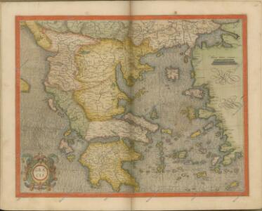
Graeciae Universae Secundum Hodiernum Situm Neoterica Descriptio. [Karte], in: Theatrum orbis terrarum, S. 347.
1 Karte aus Atlas Ortelius, Abraham Vrients, Jan Baptista
Grece moderne, Archipel, Albanie, Macedoine.
1 : 2400000 Brue, Adrien Hubert, 1786-1832
Decima Europe Tabula [Karte], in: [Clavdii Ptholomei Cosmographi ...], S. 284.
1 Karte aus Atlas Nicolaus Germanus [und Ptolemaeus, Claudius]
Anbau und Juli-Isothermen
Balkanhalbinsel Pflanzenbau, Klima
Grece Ancienne, Macedoine, Thrace, &a.
1 : 2400000 Picquet, C.
Composite: Graeciae Antiquae.
1 : 1280000 L'Isle, Guillaume de, 1675-1726
Composite: Graeciae Antiquae tabula nova.
1 : 1280000 L'Isle, Guillaume de, 1675-1726
Nova Totius Graeciae descriptio. [Karte], in: Novus atlas absolutissimus, Bd. 5, S. 274.
1 Karte aus Atlas Janssonius Offizin
Graeciae Universae Secundum Hodiernum Situm Neoterica Descriptio. [Karte], in: Theatrum orbis terrarum, S. 252.
1 Karte aus Atlas Ortelius, Abraham
Die Balkan-Halbinsel
1 : 1500000 Athény (Řecko : oblast) Vogel, Carl Domann, B. Justus Perthes
Die Balkan-Halbinsel
1 : 1500000 Athény (Řecko : oblast) Vogel, Carl Domann, B. Justus Perthes
Politisch - militärische Karte der Balkanhalbinsel

Soubor němých map pro gymnasia a odborné školy

Graecia cum terris adjacentibus
Griechenland
Graecia. [Karte], in: Novus Atlas, das ist, Weltbeschreibung, Bd. 3, S. 332.
1 Karte aus Atlas Blaeu, Joan Blaeu, Willem Janszoon
Grece ancienne et de la Mer Egee.
1 : 2400000 Brue, Adrien Hubert, 1786-1832
Grece Ancienne.
1 : 2640000 Monin, C.V.
Südosteuropäische Halbinsel, Geologische Übersicht
Südosteuropa
Der Europäische Theil des Osmanischen Reichs oder die Europäische Türkey
Stieler's Hand-Atlas Stieler, Adolf bei Justus Perthes