Maps of Highland

Pascaert vande westkust van Schotlant, als mede een gedeelte van de Lewys Eylanden, van S. Patricius tot Nary, Nog t'I. Roda ofte Barre en t'I. S. Kilda met al Syn diepten en droochten, dus ver naeuke
Keulen, Johannes van, 1654-1715
The Shires of Ross, and Cromartie / by Her. Moll.
Moll, Herman, d. 1732
Ordnance Survey of Great Britain, Scotland
Ordnance Survey
Extima Scotiæ septentrionalis ora
1 Karte : Kupferdruck ; 40 x 50 cm Blaeu; Gordon Joan Blaeu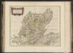
Extima Scotiae septentrionalis ora, ubi Provinciae sunt Rossia, Sutherlandia, Cathenesia, Strath-Naverniae, cum vicinis regiunculis quae eis subsunt, etiamque Moravia / R. Gordonius à Strath-loch coll
Gordon, Robert, 1580-1661 Blaeu, Joan, 1596-1673
Extimae Scotiae pars Septentrionalis, in qua Provinciae Rossia, Sutherlandia, Cathenesia, et Strath-Naverniae. [Karte], in: Novus atlas absolutissimus, Bd. 8, S. 166.
1 Karte aus Atlas Janssonius Offizin
Western Isles.
Thomson, John, 1777- ca. 1840 Johnson, William, fl. 1806-1840
Western Isles.
Thomson, John, 1777- ca. 1840 Johnson, William, fl. 1806-1840
Western Isles.
Thomson, John, 1777- ca. 1840 Johnson, William, fl. 1806-1840
[Kaart], uit: Sutherland & Caithness
1 : 253440 titelvariant: Sutherland and Caithness; Annotatie: Titel op omslag: Sutherland and Caithness; Verso: bladoverzicht reeks Edinburgh : Bartholomew
EXTIMA SCOTIÆ | SEPTENTRIONALIS ORA, | ubi Provinciæ sunt | ROSSIA, SVTHERLANDIA, CATHENESIA, | STRATH-NAVERNIÆ, | cum vicinis regiunculis quæ eis subsunt, etiamque | MORAVIA.
R. Gordonius à Strath-loch collegit et descripsit. [Amsterdam : Joan Blaeu]
Scotland / J. Ainslie, 2
1 Blatt : 68 x 58 cm Ainslie, Faden
A general map of Scotland and islands thereto belonging, 1
2 Blätter : 90 x 76 cm s.n.
Scotland[Motoring Map of]
London : "Geographia
Scotland / J. Ainslie, 1
1 Blatt : 64 x 58 cm Ainslie, Faden
A new chart of the West coast of Scotland from the Mull of Galloway to Dunan Point in Sky.
Huddart, Joseph, 1740/1-1816 Laurie, Robert Whittle, James
Carte particuliere de la cote occidentale d'Escosse, depuis le Cape Wrath jusqu'a la Pointe d'Ardnamurchan.
Depot Generale de la Marine, Paris
A new chart of the West coast of Scotland from the point of Ardnamurchan to Cape Wrath.
Huddart, Joseph, 1740/1-1816 Laurie, Robert Whittle, James
Tabula Leogi et Haraiæ, ac Skiæ vel Skianæ insularum
1 Karte : Kupferdruck ; 43 x 51 cm Valck; Schenk ex officina Gerardi Valk et Petri Schenk
Scotland[Motoring Map of]
London : "Geographia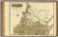
Ross, Cromarty Shires N.
1 : 190000 Craig, John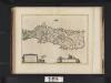
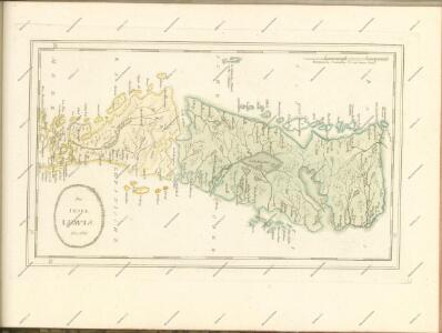
Leogus et Haraia insulae ex Aebudarum numero, quae quamquam isthmo cohaereant, pro diversis habentur. Lewis and Harray of the numbre of the Western Yles, which two although they ioyne be a necke of la
Blaeu, Joan, 1596-1673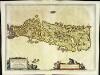
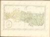
Leogvs et Haraia
1 Karte : Kupferdruck ; 38 x 51 cm Blaeu Joan Blaeu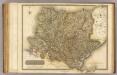
Sutherland Shire.
1 : 172000 Thomson, John
Sutherlandshire.
Forbes, William, fl. 1790-1826
Sketch of the the county of Sutherland showing the boundaries & divisions of the earldom of Sutherland.
Anon.
Map of the county of Sutherland made on the basis of the trigonometrical survey of Scotland in the years 1831, 1832.
Burnett, Gregory, fl. 1820?-1844 Scott, William, fl. ca. 1830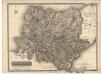
Sutherland Shire.
Thomson, John, 1777- ca. 1840 Johnson, William, fl. 1806-1840