Maps of Outer Hebrides

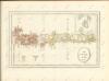
Tabula Leogi et Haraiæ, ac Skiæ vel Skianæ insularum
1 Karte : Kupferdruck ; 43 x 51 cm Valck; Schenk ex officina Gerardi Valk et Petri Schenk
Scotland[Motoring Map of]
London : "Geographia
Scotland / J. Ainslie, 1
1 Blatt : 64 x 58 cm Ainslie, Faden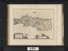
Leogus et Haraia insulae ex Aebudarum numero, quae quamquam isthmo cohaereant, pro diversis habentur. Lewis and Harray of the numbre of the Western Yles, which two although they ioyne be a necke of la
Blaeu, Joan, 1596-1673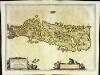
Leogvs et Haraia
1 Karte : Kupferdruck ; 38 x 51 cm Blaeu Joan Blaeu
LEOGVS et HARAIA, | insulæ ex Æbudarum numero, | quæ, quamquam isthmo cohæreant, | pro diversis habentur. | LEWIS and HARRAY | of the numbre of the Westerne Yles, which two although | they ioyne be a necke of land ar accounted dyvers Ylands.
[Amsterdam : Joan Blaeu]
Harris & The Lewis, Sheet 23 - Bartholomew's "Half Inch to the Mile Maps" of Scotland
1 : 126720 Topographic maps John Bartholomew & Son, Ltd John Bartholomew & Son, Ltd
Outer Hebrides, Sheet 23 - Bartholomew's "Half Inch to the Mile Maps" of Scotland
1 : 126720 Topographic maps Bartholomew, John George John Bartholomew & Co
Skia vel Skiana
1 Karte : Kupferdruck ; 40 x 51 cm Blaeu; Pont Joan Blaeu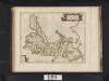
Skia vel Skiana, [vulgo], The Yle of Skie / Auct. Timotheo Pont.
Pont, Timothy, 1560?-1614? Blaeu, Joan, 1596-1673
The Lewis or north part of Long Island.
Mackenzie, Murdoch (Senior), 1712-1797
Island of Skye
1 : 126720 Ordnance Survey Office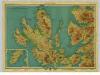
Isle of Skye, Sheet 19 - Bartholomew's "Half Inch to the Mile Maps" of Scotland
1 : 126720 Topographic maps John Bartholomew & Son, Ltd John Bartholomew & Son, Ltd
Isle of Skye, Sheet 19 - Bartholomew's "Half Inch to the Mile Maps" of Scotland
1 : 126720 Topographic maps Bartholomew, John George John Bartholomew & Co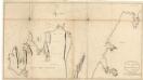
The north part of Sky island and the adjacent main of Scotland.
Mackenzie, Murdoch (Senior), 1712-1797
Uist & Barra, Sheet 18 - Bartholomew's "Half Inch to the Mile Maps" of Scotland
1 : 126720 Topographic maps John Bartholomew & Son, Ltd John Bartholomew & Son, Ltd
North & South Uist, Sheet 18 - Bartholomew's "Half Inch to the Mile Maps" of Scotland
1 : 126720 Topographic maps Bartholomew, John George John Bartholomew & Co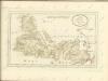

VISTVS INSVLA, | vulgo VIIST, | cum aliis minoribus | EX ÆBVDARVM NVMERO | ei ad meridiem adjacentibus.
Auct. Timotheo Pont. [Amsterdam : Joan Blaeu]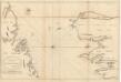
The channel between Sky I and the Lewis.
Mackenzie, Murdoch (Senior), 1712-1797
SKIA vel SKIANA | The Yle of SKIE
Auct. Timotheo Pont. [Amsterdam : Joan Blaeu]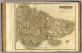
Western Isles N.
1 : 107000 Thomson, John
Vistus Insula, vulgo Viist, cum aliis minoribus ex Aebudarum numero ei ad meridiem adjacentibus / Auct. Timotheo Pont.
Pont, Timothy, 1560?-1614? Blaeu, Joan, 1596-1673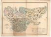
Plan of the island of Lewis reduced from Mr Chapman's survey
Chapman, James, fl. 1784-1834 Johnson, William, fl. 1806-1840
Skye Island &c.
1 : 139000 Johnson, William, fl. 1806-1840
Harris - Bartholomew's 'Survey Atlas of Scotland'
1 : 126720 Topographic maps John Bartholomew & Son, Ltd John Bartholomew & Son, Ltd
Skye Island, &c.
Thomson, John, 1777- ca. 1840 Johnson, William, fl. 1806-1840
Portree - Bartholomew's 'Survey Atlas of Scotland'
1 : 126720 Topographic maps John Bartholomew & Son, Ltd John Bartholomew & Son, Ltd
Western Isles Middle.
1 : 110000 Thomson, John