Maps of United Kingdom
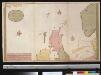
Nieuwe paskaert vant Noorderdeel der Noord Zee als meede een gedeelte van de West cust van Schotlant en Irland seer dienstigh voor de kruijsers op de Oostindise scheepen
Scotland Gerard van Keulen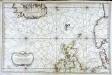
Carte réduite de partie de la mer du Nord comprise entre l'Ecosse, le Dannemark, la Norwege et l'Islande
1 Karte : Kupferdruck ; 55 x 83 cm Bellin s.n.
[VII], uit: Geognostische Karte des Oesterreichischen Kaiserstaates mit einem grossen Theile Deutschland's u. Italien / hauptsachlich nach ... Haidinger's geognostischer Karte dieses Staates bearb. von Josef Scheda
1 : 3000000 titelvariant: General-Karte von Europa in 25 Blättern; Annotatie: Bijlage bij: General-Karte von Europa in 25 Blättern. - 1:2.592.000. - 1845-1847 Scheda, Joseph Wien : K.K. Militär. Geografisch. Institut
Great Britain & Ireland.
1 : 4250000 Bowen, Emanuel
Mare Germanicum ac tractus maritimus retro Hiberniam et Scotiam
1 Karte : Kupferdruck ; 47 x 56 cm Renard apud L. Renard
[123][126] Pascaert vande Noort-Zee om achter Yrland en Schotland om te seylen, uit: Atlas sive Descriptio terrarum orbis
Annotatie: Gedigitaliseerde versie. Amsterdam. Heiloo : Picturae (vervaardiger), 2015. tiff-bestand. Gedigitaliseerd: 07-01-2015; Origineel: Universiteitsbibliotheek Vrije Universiteit (XL.05127.-) ; Netherlands; Titelpagina ontbreekt Wit, Frederik de Amsterdam : Frederick de Wit
Die Britischen Inseln
[Allgemeiner Atlas über alle Theile der Erde in 29 Blättern] Ziegler, Jakob Melchior Top. Anstalt v. J. Wurster u. Comp.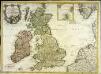
Carte des isles Britanniques contenant les royaumes d'Angleterre, d'Ecosse, d'Irlande et isles dépendantes
1 Karte : Kupferdruck ; 53 x 72 cm Flink; Mondhare chés Mondhare rue St. Jacques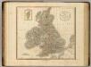
British Isles.
1 : 2550000 Cary, John, ca. 1754-1835
Grossbritanien und Ireland
Neuester Schul-Atlas Walch, Johann im Verlag bei Joh. Walch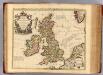
Isles Britanniques.
1 : 2500000 L'Isle, Guillaume de, 1675-1726
Les isles britanniques ou les royaumes d'Angleterre, d'Ecosse et d'Irlande
1 Karte : Kupferdruck ; 48 x 62 cm Le Rouge Le Rouge rue des Augustins vis a vis le panier Fleury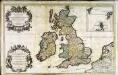
Les isles britanniques; qui contiennent les royaumes, d'Angleterre, Escosse, et Irlande
1 Karte auf 2 Blätter : Kupferdruck ; 53 x 85 cm Sanson; Jaillot; Speed; Gordon; Pont; Saxton; Camden; Boazio chez H. Iaillot joignant les grands Augustins aux deux globes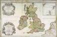
Les isles britanniques; qui contiennent les royaumes, d'Angleterre, Escosse, et Irlande
1 Karte auf 2 Blättern : Kupferdruck ; 54 x 87 cm Sanson; Jaillot; Speed; Gordon; Pont; Saxton; Camden; Boazio chez H. Iaillot joignant les grands Augustins aux deux globes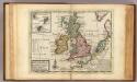
A general map of Great Britain and Ireland.
1 : 7500000 Moll, Herman, d. 1732
British Isles - Physical Geography..
Milner, Thomas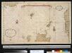
Het Noorder deel van de Noord Zee seer dienstig voor de Oostindise kruijsers
North Sea Gerard van Keulen
Les isles Britanniques comprenant les royaumes d'Angleterre, Ecosse et Irlande
1 Karte : Kupferdruck ; 51 x 67 cm Crépy; Crépy chez Crepy rue S. Jacques à l'Image Saint
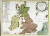
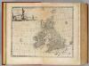
Magna Britannia
1 Karte : Kupferdruck ; 47 x 55 cm Homännische Erben
Magna Britannia
1 Karte : Kupferdruck ; 46 x 55 cm Homännische Erben
Les isles britanniques qui contiennent les royaumes d'Angleterre, Escosse, et Irlande
1 Karte : Kupferdruck ; 46 x 58 cm Jaillot; Ottens; Ottens chez Reinier et Iosua Ottens
Les isles britanniques qui contiennent les royaumes d'Angleterre, Escosse, et Irlande
1 Karte : Kupferdruck ; 46 x 58 cm Jaillot A. H. Jaillot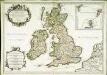
Les isles britanniques; qui contiennent les royaumes d'Angleterre, Escosse, et Irlande
1 Karte : Kupferdruck ; 44 x 64 cm Sanson; Jaillot; Cordier; Simonneau; Pont; Saxton; Camden; Boazio; Speed; Gordon Chez H. Iaillot joignant les grands Augustins aux deux globes
De nieuwe aftekening van de Noordzee : van Tessel tot aan Drontem waar in de miswijsing moet verbeterd worden na de opservatie van de heer captijn Suhm
North Sea Suhm Gerard van Keulen
Feuille 16 (B III), uit: Carte géologique internationale de l'Europe : la carte, votée au congrès géologique international de Bologne en 1881, est exécutée conformément aux décisions d'une commission internationale, avec le concours des gouvernements, sous le dir. de M.M. Beyrich et Hauchecorne
Annotatie: Blad 48 gamme des couleurs; blad 49: bladwijzer en titelblad Heinrich Ernst Beyrich 1815-1896; Wi. Hauchecorne Berlin : Reimer / (Berlin: Institut lithographique)
Great Britain and Ireland.
1 : 4100000 Gray, Ormando Willis
Die Britischen Inseln Und Das Umliegende Meer.
1 : 3700000 Petermann, A.
Les isles Britanniques comprenant les royaumes d'Angleterre, Ecosse et Irlande
1 Karte : Kupferdruck ; 51 x 67 cm Crépy; Crépy chez Crepy rue S. Jacques à l'Image Saint