Maps of United Kingdom

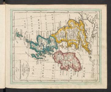
Grossbritanien und Ireland
Neuester Schul-Atlas Walch, Johann im Verlag bei Joh. Walch
Die Britischen Inseln
[Allgemeiner Atlas über alle Theile der Erde in 29 Blättern] Ziegler, Jakob Melchior Top. Anstalt v. J. Wurster u. Comp.
Prima Europe Tabula [Karte], in: [Clavdii Ptholomei Cosmographi ...], S. 245.
1 Karte aus Atlas Nicolaus Germanus [und Ptolemaeus, Claudius]
Les Isles Britanniques ou sont le royaumes d'Angleterre
1 : 2534400
Paskaert, de Kusten van't Kanael, vertoonende alle, de Kusten van Engelandt, Schotlant, en Yerlandt, en een gedeelte van Vranckrijck.
from De zee-atlas ofte water-wereld : waer in vertoont werden alle de zee-kusten van het bekende des aerd-bodems : seer dienstigh voor alle heeren en kooplieden, als oock voor alle schippers en stuurlieden / by Pieter Goos.
Die Britischen Inseln und das Umliegende Meer
Handatlas über alle Theile der Erde und über das Weltgebäude Stieler, Adolf Justus Perthes
Great Britain & Ireland.
1 : 4250000 Bowen, Emanuel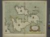
A new and correct chart of the sea coast of ENGLAND, SCOTLAND and IRELAND
from The sea-atlas : containing an hydrographical description of most of the sea-coasts of the known parts of the world.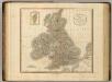
British Isles.
1 : 2550000 Cary, John, ca. 1754-1835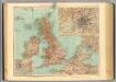
45-46. Gran Bretagna.
1 : 3000000 Touring club italiano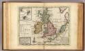
A general map of Great Britain and Ireland.
1 : 7500000 Moll, Herman, d. 1732
Les isles Britanniques comprenant les royaumes d'Angleterre, Ecosse et Irlande
1 Karte : Kupferdruck ; 51 x 67 cm Crépy; Crépy chez Crepy rue S. Jacques à l'Image Saint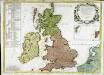
Les isles Britannicques ou sont le royaume d'Angleterre diuisé en ses quatre roy.mes des Saxons
1 Karte : Kupferdruck ; 52 x 71 cm Speed; Gordon; Pont s.n.
Great Britain and Ireland.
1 : 4100000 Gray, Ormando Willis
[123][126] Pascaert vande Noort-Zee om achter Yrland en Schotland om te seylen, uit: Atlas sive Descriptio terrarum orbis
Annotatie: Gedigitaliseerde versie. Amsterdam. Heiloo : Picturae (vervaardiger), 2015. tiff-bestand. Gedigitaliseerd: 07-01-2015; Origineel: Universiteitsbibliotheek Vrije Universiteit (XL.05127.-) ; Netherlands; Titelpagina ontbreekt Wit, Frederik de Amsterdam : Frederick de Wit
Tidal Chart of the British Seas
The physical atlas Johnston, Alexander Keith William Blackwood & Sons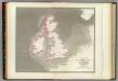
Tidal chart British Seas.
1 : 4900000 Russell, J. Scott (John Scott), 1808-1882
Anglia, Scotia et Hibernia. [Karte], in: Gerardi Mercatoris Atlas, sive, Cosmographicae meditationes de fabrica mundi et fabricati figura, S. 82.
1 Karte aus Atlas Mercator, Gerhard Montanus, Petrus
INSVLÆ | ALBION | et | HIBERNIA | cum minoribus adjacentibus
[Amsterdam : Joan Blaeu]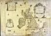
Les isles britaniques ou sont les royaumes d'Angleterre et d'Escosse que nous appellons la Grande Bretagne et celui d'Irlande
1 Karte auf 4 Blättern : Kupferdruck ; 72 x 86 cm Duval; Duval chez Mad.lle Du-Val fille de l'auteur sur le quay de l'Horloge du Palays pres la rue de Harlay a la couronne d'or
Carte des isles britaniques, où sont les royaumes d'Angleterre, et d'Escosse, que nous appellons Grande Bretagne
1 Karte : Kupferdruck ; 46 x 33 cm Duval chez l'auteur en l'isle du Palais sur le quay de l'Horloge
Carte des isles britaniques, où sont les royaumes d'Angleterre, et d'Escosse, que nous appellons Grande Bretagne
1 Karte : Kupferdruck ; 46 x 33 cm Duval chez l'auteur en l'isle du Palais sur le quay de l'Horloge
Les isles Britanniques comprenant les royaumes d'Angleterre, Ecosse et Irlande
1 Karte : Kupferdruck ; 51 x 67 cm Crépy; Crépy chez Crepy rue S. Jacques à l'Image Saint
Magna Britannia
1 Karte : Kupferdruck ; 47 x 55 cm Homännische Erben
Magna Britannia
1 Karte : Kupferdruck ; 46 x 55 cm Homännische Erben
Les isles britanniques qui contiennent les royaumes d'Angleterre, Escosse, et Irlande
1 Karte : Kupferdruck ; 46 x 58 cm Jaillot; Ottens; Ottens chez Reinier et Iosua Ottens
Les isles britanniques qui contiennent les royaumes d'Angleterre, Escosse, et Irlande
1 Karte : Kupferdruck ; 46 x 58 cm Jaillot A. H. Jaillot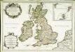
Les isles britanniques; qui contiennent les royaumes d'Angleterre, Escosse, et Irlande
1 Karte : Kupferdruck ; 44 x 64 cm Sanson; Jaillot; Cordier; Simonneau; Pont; Saxton; Camden; Boazio; Speed; Gordon Chez H. Iaillot joignant les grands Augustins aux deux globes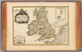
Isles Britanniques.
1 : 3800000 Janvier, Jean