Maps of Mindanao

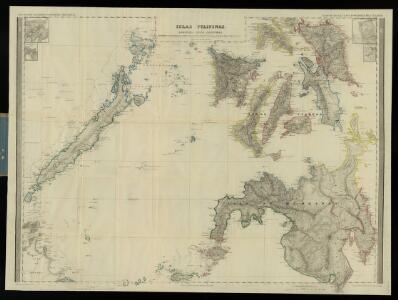
Islas Filipinas, 2a hoja / por el teniente coronel de ingenieros D. Francisco Coello ; las notas estadisticas e historicas han sido escritas por D. Pascual Madoz
1 : 1000000 1 full d'un mapa en tres fulls, b/n. Dins: Atlas de España y sus posesiones de ultramar Coello, Francisco ; Madoz, Pascual [Imprenta del Atlas de España]
[Islas Filipinas, Segunda Hoja Central]
1 : 1000000 Morata, Antonio [Verlag nicht ermittelbar]
Philippines.
1 : 2280000 Rand McNally and Company
Sooloo Sea, Archipelago.
1 : 3600000 United States Exploring Expedition (1838-1842)
Partie, Iles Philippines. Oceanique no. 6.
1 : 1641836 Vandermaelen, Philippe, 1795-1869
No. 26. Mindanao Jolo.
1 : 2500000 U.S. Coast and Geodetic Survey
[Islas filipinas - Mindanao Joló]
Atlas de Filipinas Algué, P. José Government Printing Office
Mer de Chine Ile de Palawan
[Mer de Chine. Île de Palawan, d'après les travaux du Capite W.T. Bate et autres Officiers de la Marine Royale Anglaise et d'après divers documents étrangers] Paris
Geologic reconnaissance map of Mindanoa / Bureau of Science, Division of Mines ; P. Moskaira, engraved ; geology by Warren D. Smith
Bureau of Science . Division of Mines [S.l.] : Bureau of Science
No. 27. Mindanao Oriental.
1 : 1830000 U.S. Coast and Geodetic Survey
[Islas filipinas - Mindanao oriental]
Atlas de Filipinas Algué, P. José Government Printing Office
[Islas filipinas - Norte de Paragua]
Atlas de Filipinas Algué, P. José Government Printing Office
No. 24. Norte de Paragua.
1 : 147000 U.S. Coast and Geodetic Survey
[Islas filipinas - Mindalao occidential, Joló]
Atlas de Filipinas Algué, P. José Government Printing Office
No. 28. Mindanao Occidental, Jolo.
1 : 1450000 U.S. Coast and Geodetic Survey
Partie des Iles Philippines / [dressée par Ph. Vandermaelen]
[Bruxelles : P.M.G. Vandermaelen, Éditeur]
South Mindanao / Topografische Dienst
Topografische Dienst Batavia Batavia : Reproductiebedrijf Topografische Dienst
[Islas filipinas - Sur de Paragua, Balábac]
Atlas de Filipinas Algué, P. José Government Printing Office
[Islas filipinas - Negros]
Atlas de Filipinas Algué, P. José Government Printing Office
[Islas filipinas - Sámar]
Atlas de Filipinas Algué, P. José Government Printing Office
No. 18. Samar.
1 : 686000 U.S. Coast and Geodetic Survey
No. 25. Sur de Paragua, Balabac.
1 : 815000 U.S. Coast and Geodetic Survey
[Islas filipinas - Leyte]
Atlas de Filipinas Algué, P. José Government Printing Office
No. 21. Negros.
1 : 665000 U.S. Coast and Geodetic Survey
[Islas filipinas - Cebú]
Atlas de Filipinas Algué, P. José Government Printing Office
[Islas filipinas - Panay]
Atlas de Filipinas Algué, P. José Government Printing Office
No. 20. Panay.
1 : 640000 U.S. Coast and Geodetic Survey
No. 22. Cebu.
1 : 642000 U.S. Coast and Geodetic Survey
No. 19. Leyte.
1 : 660000 U.S. Coast and Geodetic Survey