Maps of Mindanao

No. 26. Mindanao Jolo.
1 : 2500000 U.S. Coast and Geodetic Survey
[Islas filipinas - Mindanao Joló]
Atlas de Filipinas Algué, P. José Government Printing Office
Geologic reconnaissance map of Mindanoa / Bureau of Science, Division of Mines ; P. Moskaira, engraved ; geology by Warren D. Smith
Bureau of Science . Division of Mines [S.l.] : Bureau of Science
No. 27. Mindanao Oriental.
1 : 1830000 U.S. Coast and Geodetic Survey
[Islas filipinas - Mindanao oriental]
Atlas de Filipinas Algué, P. José Government Printing Office
South Mindanao / Topografische Dienst
Topografische Dienst Batavia Batavia : Reproductiebedrijf Topografische Dienst
No. 28. Mindanao Occidental, Jolo.
1 : 1450000 U.S. Coast and Geodetic Survey
[Islas filipinas - Mindalao occidential, Joló]
Atlas de Filipinas Algué, P. José Government Printing Office
Partie des Iles Philippines / [dressée par Ph. Vandermaelen]
[Bruxelles : P.M.G. Vandermaelen, Éditeur]
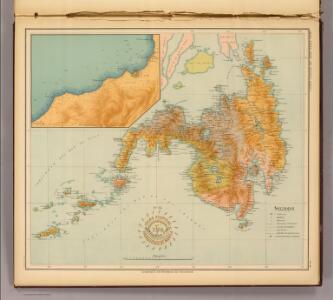
[Islas filipinas - Negros]
Atlas de Filipinas Algué, P. José Government Printing Office
[Islas filipinas - Bohol]
Atlas de Filipinas Algué, P. José Government Printing Office
No. 23. Bohol.
1 : 363000 U.S. Coast and Geodetic Survey
No. 21. Negros.
1 : 665000 U.S. Coast and Geodetic Survey
[Islas filipinas - Cebú]
Atlas de Filipinas Algué, P. José Government Printing Office
No. 22. Cebu.
1 : 642000 U.S. Coast and Geodetic Survey
Chart of the Philippine Islands, from the Spanish chart in 1808, the adjacent islands are added from the lastest surveys
1 : 1660000 Arrowsmith, Arron Arrowsmith, Aaron
[Islas Filipinas, Segunda Hoja Central]
1 : 1000000 Morata, Antonio [Verlag nicht ermittelbar]
Islas Filipinas, 2a hoja / por el teniente coronel de ingenieros D. Francisco Coello ; las notas estadisticas e historicas han sido escritas por D. Pascual Madoz
1 : 1000000 1 full d'un mapa en tres fulls, b/n. Dins: Atlas de España y sus posesiones de ultramar Coello, Francisco ; Madoz, Pascual [Imprenta del Atlas de España]
Philippine Islands.
1 : 2471000 Rand McNally and Company
Philippines.
1 : 2280000 Rand McNally and Company
A collection of charts prepared from various sources by Alexander Dalrymple, Philipinas, 1794
[A collection of charts prepared from various sources by Alexander Dalrymple and showing the coasts of West and South Africa, the Indian Ocean, Malay Archipelago, China, the Moluccas and New Holland] London : Alexander Dalrymple.
Sooloo Sea, Archipelago.
1 : 3600000 United States Exploring Expedition (1838-1842)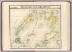
Partie, Iles Philippines. Oceanique no. 6.
1 : 1641836 Vandermaelen, Philippe, 1795-1869
Partie, Iles Philippines. Oceanique no. 7.
1 : 1641836 Vandermaelen, Philippe, 1795-1869
[Islas filipinas - Leyte]
Atlas de Filipinas Algué, P. José Government Printing Office
No. 19. Leyte.
1 : 660000 U.S. Coast and Geodetic Survey
Schetskaart van de Sangi- en Talaud Eilanden / E[ncyclopaedisch] B[ureau]
Encyclopaedisch Bureau Batavia ['s-Gravenhage : N.V. Electrische Drukkerij 'Luctor et Emergo']
No. 24. Norte de Paragua.
1 : 147000 U.S. Coast and Geodetic Survey
REDUZIRTE-KARTE VON DEN PHILIPPINEN und den SULU INSELN
1 : 2400000 Filipíny Berghaus, Heinrich Karl Wilhelm Aragon, Ildefonso de Justus Perthes