Maps of Kútniky

III. vojenské mapování 4859/2
1 : 25000
Duna-Szerdehely und Hédervár
1 : 75000 Dunajská Streda, Hédervár Geripp: Oberjgr. Richter. Terrain: Wachtm. R. v. Palitschek
Dunajská Streda
1 : 75000 Dunajská Streda (Slovensko : oblast) Vojenský zeměpisný ústav
Dun. Streda a Hédervár
1 : 75000 Dunajská Streda (Slovensko : oblast) Vojenský zeměpisný ústav
III. vojenské mapování 4859
1 : 75000
Duna-Szerdahely und Hedervar.
from Spezialkarte der osterreichisch-ungarischen Monarchie.
Wartberg und Tallos (Ungarn).
from Spezialkarte der osterreichisch-ungarischen Monarchie.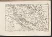
C. Posoniensis. Tab. II
Slowakei Komitat Preßburg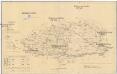
Komorner Comitat
1 : 290000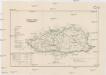
Komorner Comitat
1 : 288000 Komárno (Slovensko)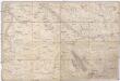
Special Karte von Ungarn
1 : 14400 Györ (Maďarsko : oblast) K.K. Militärisch-Geographisches Institut
COMITATVS POSONIENSIS Germanis PRESBVRG dicti Delineatio Geographica
1 : 113000 Bratislava-oblast (Slovensko) Mikoviny, Sámuel curantibus] Homannianis [Heredibus
Poszony vármegye térképe
1 : 300000 Bratislava (Slovensko : oblast) Kogutowicz, Manó Magyar Földrajzi Intézet
Mappa Comitatvs Posoniensis
1 : 240000 Mollova mapová sbírka Nicolaï, Georg David Christoph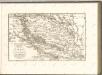

Uibersichts Karte der projectirten Tracen, der Wien-Raaber Eisenbahn sammt Nebenzweigen
1 : 430000 Győr (Maďarsko) M. Schönerer
Mappa Comitatvs Posoniensis
1 : 250000 Mollova mapová sbírka Bel, Matej Nicolaï, Georg David Christoph Bel, Matej
Comitat Pressburg
1 : 280000 Bratislava-oblast (Slovensko)
Comitat Pressburg
1 : 300000 Bratislava (Slovensko : oblast)
Komárom Vármegye
1 : 340000 Slovensko jižní
Stolice Prešpurk a Nitra
Bratislava, Nitra, ethnische Gruppe
Mappa Comitatvs Nitriensis :
1 : 170000 Mollova mapová sbírka Mikoviny, Sámuel Nicolaï, Georg David Christoph
Generalkarte von Zentraleuropa

Mappa Comitatus Posoniensis Accuratione Astronomico-Geometrica concinnata opera.
1 : 140000 Mollova mapová sbírka Mikoviny, Sámuel Straub, Paul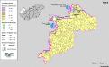
Siedlungsgebiet der Deutschen nach dem Nachbarschaftsindex für Westungarn 1941
Ungarn, Transdanubien, Deutsche, Siedlung Bottlik, Zsolt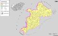
Siedlungsgebiet der Deutschen nach dem Nachbarschaftsindex für Westungarn 1980
Ungarn, Transdanubien, Deutsche, Siedlung Bottlik, Zsolt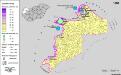
Siedlungsgebiet der Deutschen nach dem Nachbarschaftsindex für Westungarn 1880
Ungarn, Transdanubien, Deutsche, Siedlung Bottlik, Zsolt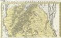
Comitatvs Posoniensis Germanis Presbvrg dicti Delineatio Geographica
1 : 150000 Mollova mapová sbírka Homann, Johann Baptist Alber, Johann Eberhard Homann, Johann Baptista - dědici
Kroaten in West-Ungarn 1941
Transdanubien Kroaten, Siedlung Bottlik, Zsolt


