Maps of Trnavský

Mappa Comitatvs Posoniensis
1 : 250000 Mollova mapová sbírka Bel, Matej Nicolaï, Georg David Christoph Bel, Matej
Comitat Pressburg
1 : 280000 Bratislava-oblast (Slovensko)
Comitat Pressburg
1 : 300000 Bratislava (Slovensko : oblast)
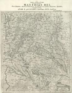
Mappa Comitatvs Posoniensis
1 : 240000 Mollova mapová sbírka Nicolaï, Georg David Christoph
Poszony vármegye térképe
1 : 300000 Bratislava (Slovensko : oblast) Kogutowicz, Manó Magyar Földrajzi Intézet
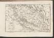
COMITATVS POSONIENSIS Germanis PRESBVRG dicti Delineatio Geographica
1 : 113000 Bratislava-oblast (Slovensko) Mikoviny, Sámuel curantibus] Homannianis [Heredibus
Bratislava okolie

Stolice Prešpurk a Nitra
Bratislava, Nitra, ethnische Gruppe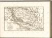
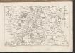
C. Posoniensis. Tab. I
Slowakei Komitat Preßburg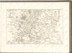
C. Posoniensis. Tab. II
Slowakei Komitat Preßburg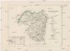
Ober-Neutraer Comitat
1 : 280000 Nitra-oblast (Slovensko)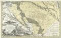
Comitatvs Posoniensis Germanis Presbvrg dicti Delineatio Geographica
1 : 150000 Mollova mapová sbírka Homann, Johann Baptist Alber, Johann Eberhard Homann, Johann Baptista - dědici
C. Mosoniensis
Ungarn Komitat Moson
Comitat Wieselburg
1 : 280000 Mosonmagyaróvár (Maďarsko)
Comitat Wieselburg
1 : 280000
Moson vármegye
1 : 130000 Neziderské jezero (Maďarsko a Rakousko : oblast) Kováts, János Görög, Demeter Görög

C. Nitriensis. Tab. II
Slowakei Komitat Neutra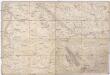
Special Karte von Ungarn
1 : 14400 Györ (Maďarsko : oblast) K.K. Militärisch-Geographisches Institut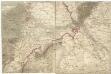
[Wien, Pressburg, Neusiedler See]
1 : 144000 Bratislava-oblast (Slovensko)
III. vojenské mapování 4658/4
1 : 25000
Petronell - Raab
Mollova mapová sbírka Marsili, Luigi Ferdinando
Mappa Comitatus Mosoniensis
Mollova mapová sbírka Kovács, János Nicolaï, Georg David Christoph
Duna-Szerdahely und Hedervar.
from Spezialkarte der osterreichisch-ungarischen Monarchie.
Wartberg und Tallos (Ungarn).
from Spezialkarte der osterreichisch-ungarischen Monarchie.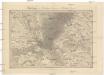
Umgebungen von Hainburg in Oesterreich, und Presburg in Ungarn
1 : 144000 Bratislava-oblast (Slovensko) Müller, A. Withalm, Andreas
Umgebung von Pozsony
1 : 75000 Bratislava (Slovensko : oblast) K. u. k. Militärgeographisches Institut