Maps of Maine

A map of the district of Maine : drawn from the latest surveys and other best authorities
1 : 1170000 Carleton, Osgood, 1742-1816 Thomas & Andrews
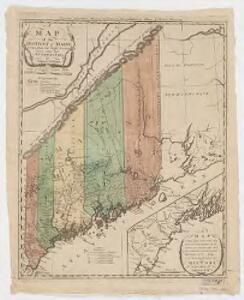
The district of Main : from the latest surveys
1 : 2800000 Carleton, Osgood, 1742-1816 by Isaiah Thomas and Ebenezer T. Andrews
The district of Main : from the latest surveys
1 : 2900000 Carleton, Osgood, 1742-1816
State Of Maine With The Province Of New Brunswick.
1 : 570240 Greenleaf, Moses, 1777-1834
Maine
1 : 1020000 Sotzmann, D. F Bey Carl Ernst Bohn
State Of Maine With The Province Of New Brunswick.
1 : 570240 Greenleaf, Moses, 1777-1834
County map of the State of Maine ; Portland Harbor and vicinity [inset].
from New general atlas.
Various Regions and Cities in and around Maine including Canadian Maritime Provinces.
Shell Oil Company
Maine, New Brunswick, with portions of Quebec and Nova Scotia.
1 : 1265000 Asher & Adams
Maine, N.B.
1 : 1267200 Asher & Adams
Schonberg's Map of Maine and New Brunswick.
1 : 1900000 Schonberg & Co.
Lower Canada And New Brunswick.
1 : 2217600 Goodrich, S.G.
Lower Canada and New Brunswick.
1 : 2217600 Bradford, Thomas G.
Shell Maritime Provinces.
1 : 2090880 Shell Oil Company
Colton's railroad & township map of the state of Maine, with portions of New Hampshire, New Brunswick & Canada
1 : 550000 J.H. Colton & Co J.H. Colton & Co.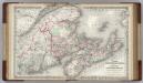
Canada. New Brunswick, Nova Scotia and Prince Edward island.
1 : 1500000 Colton, G.W.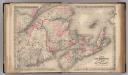
New Brunswick, Nova Scotia, Prince Edward Island, and Cape Breton Inland.
1 : 1500000 Colton, G.W.
Map of the boundary lines between the United States and the adjacent British provinces : from the mouth of the river St. Croix to the intersections of the parallel of 45 degrees of north latitude with the river St. Lawrence near St. Regis, shewing the lines as respectively claimed by the United States and Great Britain under the Treaty of 1783, as awarded by the King of the Netherlands, and as settled in 1842 by the Treaty of Washington
1 : 1020000 Lee, Thomas Jefferson, 1808-1891 United States House of Representatives
Quebec, New Brunswick, Maine, Vermont, New Hampshire.
1 : 1584000 Smith, J. Calvin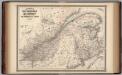
New Brunswick and Quebec.
1 : 1580000 Johnson, A.J.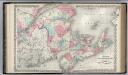
New Brunswick, Nova Scotia. Prince Edward Island. and Cape Breton Inland.
1 : 1500000 Colton, G.W.
Lower Canada.
1 : 1950000 Colton, G.W.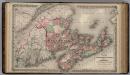
Dominion of Canada. Provinces of New Brunswick & Nova Scotia and Prince Edward Island.
1 : 1550000 Colton, G.W.
New Brunswick and Quebec.
1 : 1580000 Johnson, A.J.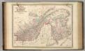
New Brunswick and Quebec.
1 : 1580000 Johnson, A.J.
Maine Central Railroad.
1 : 4200000 New England Railway Publishing Co.
Canada East Or Lower Canada And New Brunswick.
1 : 2027520 Colton, G.W.
Map of Maine, New Hampshire, and Vermont : compiled from the latest authorities
1 : 1001000 Young, J. H. (James Hamilton) S. Augustus Mitchell
Lower Canada And New Brunswick ... Upper Canada.
1 : 2027520 Johnson, A.J.