Maps of Metropolitan France

Volksdichtekarte von Mitteleuropa
1 : 9000000 Mitteleuropa Bevölkerungsdichte
Post roads Germany, Hungary.
1 : 2500000 Robert Laurie & James Whittle
Völkerkarte von Mitteleuropa
1 : 9000000 Mitteleuropa Ethnische Gruppe
Sbírka map a diagramů použitých na mírových konferencích v Paříži v letech 1919 - 1920
A new map of Germany, Hungary, Transilvania & the Suisse cantons, ...
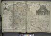
from The world described, or, A new and correct sett of maps : shewing the kingdoms and states in all the known parts of the earth, with the principal cities, and most considerable towns in the world ... / ... by Herman Moll, geographer ...
Karte der Heilquellen und Kurorte von Mittel - Europa

Eisenbahnkarte von Mittel Europa
1 : 3375000 Berlín (Německo) Broditzky, Joseph R. v. Waldheim
Eisenbahnkarte von Mittel Europa
1 : 3375000 Berlín (Německo) Broditzky, Joseph R. v. Waldheim
Eisenbahnkarte von Mittel Europa
1 : 3375000 Berlín (Německo) Broditzky, Joseph R. v. Waldheim
Eisenbahnkarte von Mittel Europa
1 : 3375000 Berlín (Německo) Broditzky, Joseph R. v. Waldheim
Eisenbahnkarte von Mittel Europa
1 : 3375000 Berlín (Německo) Broditzky, Joseph R. v. Waldheim
Mitteleuropa
1 : 8000000 Evropa střední Kocen, Blaž Eduard Hölzel
Střední Evropa v době náboženské reformace a protireformace 1517 - 1648

Neueste Post und Reise Karte der wichtigsten und besuchtesten Theile Europa's
1 : 3700000 Evropa střední Kliewer, Friedrich Wilhelm Heymann, Carl Carl Heymann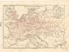
Eisenbahnkarte von Mitteleuropa

Mitteleuropa: Konfessionsgebiete
1 : 9000000 Mitteleuropa Denomination
Central-Europa
Mitteleuropa
2. Pyrenäenfriede 1659
1 : 30000000 Mitteleuropa Pyrenäenfriede
Říše Karla Velikého

Neue Ausgabe von Schulz's praktischer Reise-Karte mit Angabe der Distanzen und Eisenbahnen
Evropa střední Schulz, R. A. Artaria & Co.
Geogr.-physik.-statist. Karte von Deutschland mit Einschluss von ganz Oesterreich, Belgien, den Niederlanden, der Schweiz, Italien und einem Theile von Frankreich, England, Russland und der Türkei
1 : 4110000 Evropa střední a východní Haurand Theobald Grieben
Eisenbahn-Übersichtskarte von Mittel-Europa
Evropa R. v. Waldheim
Eisenbahn-Übersichtskarte von Mittel-Europa
Evropa R. v. Waldheim
Eisenbahn-Übersichtskarte von Mittel-Europa
Evropa
Eisenbahn-Übersichtskarte von Mittel-Europa
Evropa R. v. Waldheim
Übersichtskarte der Staaten von Mitteleuropa

Itineraire-Karte
1 : 6000000 Evropa
Übersichtskarte des Eisenbahn- und Telegraphen-Verbindungen von Mittel-Europa
1 : 6170000 Evropa střední Mayer, Alexander
Eisenbahn-Übersichtskarte von Mittel-Europa
Evropa R. v. Waldheim
Oesterreich in den Jahren 1564-1795
Evropa střední Gindely, Antonín F. Tempsky


