Maps of Poland

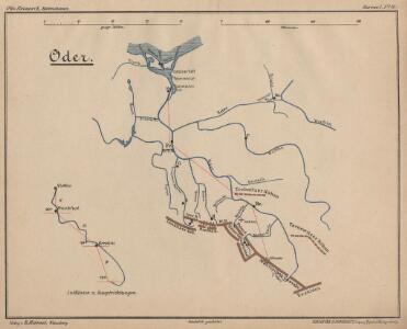
Oder
Oder, Flusslauf
Postup při tisku příruční mapy školní ČSR

87-88. Poland. The World Atlas.
1 : 1500000 USSR (Union of Soviet Socialist Republics).
Operations Karte im Jahr 1759 ...


The N. E. Part of Germany
1 : 3400000 Mollova mapová sbírka Moll, Herman Moll, Hermann
NO Deutschland.
1 : 5500000 Brudin, J. L.; Stieler, Adolf
The N.E. part of Germany.
1 : 3500000 Moll, Herman, d. 1732
Říše česká za Karla IV.

Circuli Austriaci Pars Occidentalior, Comprehendens Comitatum Principalem Tirolis Episcopatus Tridentinum et Brixensem Comitatus Brigantinum Feldkirchiae Sonnebergae Pluentii etc.
1 : 558000 Mollova mapová sbírka Wit, Frederik de Wit, Frederick
Novissima Poloniae Regni Descriptio. [Karte], in: Novus atlas absolutissimus, Bd. 1, S. 90.
1 Karte aus Atlas Janssonius Offizin
L'Empire, d'Allemagne
1 : 1200000 Mollova mapová sbírka Sanson, Nicolas Quasy, Robert
Europe Centrale (Partie Centrale).
1 : 1750000 Jouvet et Cie.
Partie, l'Allemagne. Europe 14.
1 : 1641836 Vandermaelen, Philippe, 1795-1869
Le Cours de l'Elbe et de l'Oder où sont les Electorats de Saxe et de Brandebourg, les Duchés de Mekelbourg et de Pomeranie
1 : 1400000 Mollova mapová sbírka Duval, Pierre Duval, Pierre
Bojiště válek husitských v letech 1419-1434 : do bitvy u Lipan 30. května 1434
1 : 1500000 Evropa střední Kuffner, Hanuš Wagner, Jan Eduard R. Prombergr
Posádky v Zemích koruny české a v zemích zahraničních
1 : 1500000 Evropa střední Kuffner, Hanuš Wagner, Jan Eduard nákladem R. Prombergra
Mapa království českého
1 : 1000000
Böhmische Nordbahn
Evropa střední
Karte von Deutschland in IV Blättern
1 : 825000 Nordost-Blatt Sotzmann, Daniel Friedrich im Verlage der A. G. Schneider und Weigels
NE pt. of Germany.
1 : 3150000 Bowen, Emanuel
Polonia Regnum, et Silesia Ducatus. [Karte], in: Le théâtre du monde, ou, Nouvel atlas contenant les chartes et descriptions de tous les païs de la terre, Bd. 1, S. 94.
1 Karte aus Atlas Blaeu, Willem Janszoon und Blaeu, Joan Blaeu, Willem Janszoon
Novissima Poloniae regni Descriptio
1 : 1600000 Mollova mapová sbírka Janssonius, Johannes Janssonius, Johannes I
Upper Saxony, Silesia, Lusatia.
1 : 1340000 Cary, John, ca. 1754-1835
The eastern front
1 : 2280000 Shows railways, main highways, and the Front as of Feb. 12-19 (1945.). "Restricted." "No. 6180 - R & A, OSS. 20 February 1945." United States. Office of Strategic Services. Research and Analysis Branch. [Washington, D.C.] : Lithographed in Reproduction Branch, OSS
Il Regno di Boemia la Slesia Prussiana ed Austriaca noc li Marchesati di Muravia e Lusazia

Polonia Regnum, et Silesia Ducatus. [Karte], in: Novus Atlas, das ist, Weltbeschreibung, Bd. 1, S. 73.
1 Karte aus Atlas Blaeu, Joan Blaeu, Willem Janszoon
[Nordöstliches Deutschland]
Schul-Atlas über alle Theile der Erde nach dem neuesten Zustande, und über das Weltgebäude Stieler, Adolf bei Justus Perthes
Regnum Bohemiae...Ducatus Silesiae Marchionatus Moraviae et Lusatiae...