Maps of Styria

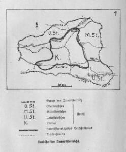
Landschaften Innerösterreichs
Innerösterreich Historische Landeskunde
Karte von Herzogthum Steyermark
1 : 840000 Štýrsko (Rakousko) Tranquillo Mollo
Charte von Herzogthum Steyermark
1 : 850000 Rakousko
Karte von Herzogthum Steyermark
1 : 860000 Štýrsko (Rakousko) Florian Mollo
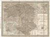
Vollstaendige Post-Karte des Herzogthums Steuermarks


Herzogthum Steyermark
Štýrsko (Rakousko)
[Štýrsko]
1 : 600000 Štýrsko (Rakousko) Anker
Charte vom Herzogthum Steyermark
1 : 870000 Štýrsko (Rakousko)
Charte vom Herzogthum Steyermark
1 : 870000 Štýrsko (Rakousko)
Blatt VI, uit: Geologische Übersichts-Karte der Österreichisch-Ungarischen Monarchie / nach den Aufnahmen der K.K. Geologischen Reichsanstalt bearb. von Franz Ritter von Hauer ; gezeichn. von Eduard Jahn
1 : 576000 Annotatie geografische gegevens: Gebaseerd op veldwerk in de jaren 1850 tot 1865 Hauer, Franz Ritter von; Jahn, Eduard; Kaiserlich-Königliche Geologische Reichsanstalt, Wenen Wien : Beck
Die Provinz Inner-OEsterreich oder die Herzogthümer Steyermark, Kaernten und Krain, die Grafschaften Goerz und Gradisca und das deutsch-oesterreichische Litorale
1 : 740000 Gorice a Gradiška Kindermann, Joseph Karl Junker, Christoph Franz Xaver Miller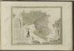
Post und Strassen Karte des Herzogthums Steyermark
1 : 380000 Mariazell (Rakousko) Schulz, R. A. Biller, Dominik Artaria & Comp.
General Post und Strassen Karte des Herzogthums Steyermark
1 : 380000 Mariazell (Rakousko) Schulz, R. A. Artaria & Comp.
Strassen-Karte des Herzogthums Steyermark
1 : 435000 Štýrsko (Rakousko)
General Post und Strassen Karte des Herzoghtums Steyermark
1 : 390000 Mariazell (Rakousko) Schulz, R. A. Artaria
General Post und Strassen Karte des Herzoghtums Steyermark
1 : 390000 Mariazell (Rakousko) Schulz, R. A. Artaria
Ducatus Stiriae novissima tabula
1 : 490000 Rakousko Homann, Johann Baptist Vischer, Georg Matthaeus J. B. Homann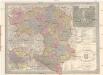
General Post und Strassen Karte des Herzogthums Steiermark
1 : 400000 Mariazell (Rakousko) Schulz, R. A. Peucker, Karl Artaria
Carte du royaume d'Illirie et du duché de Styrie
1 : 520000 Ilýrie Raffelsperger, Franz Rumpold, F. au Dépôt des cartes typografiées
Karte von Inner-Österreich, das ist des Königreiches Illirien und des Herzogthumes Steiermark
1 : 880000 Ilýrie Raffelsperger, Franz Rumpold, F. im Typographischen Landkarten-Verlage
Das Königreiche Illyrien und das Herzogthum Steyermark
1 : 700000 Ilýrie Weiland, Karl Ferdinand Anson im Verlage des geographischen Instituts
Das Königreiche Illyrien und das Herzogthum Steyermark
1 : 700000 Ilýrie Weiland, Karl Ferdinand Anson im Verlage des geographischen Instituts
Charte von dem Königreiche Illyrien und dem Herzogthume Steyermark
1 : 690000 Ilýrie Weiland, Karl Ferdinand Bürck, A. im Verlage des Geograph. Instituts
Charte von dem Königreiche Illyrien und dem Herzogthume Steyermark
1 : 690700 Ilýrie Weiland, Karl Ferdinand Bürek, A. im Verlage des Geograph. Instituts
Steyermark.
1 : 705000 Flemming, Carl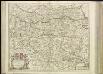
[38][38] Circuli Austriaci pars septentrionalis ..., uit: Atlas sive Descriptio terrarum orbis
Annotatie: Gedigitaliseerde versie. Amsterdam. Heiloo : Picturae (vervaardiger), 2015. tiff-bestand. Gedigitaliseerd: 07-01-2015; Origineel: Universiteitsbibliotheek Vrije Universiteit (XL.05127.-) ; Netherlands; Titelpagina ontbreekt Wit, Frederik de Amsterdam : Frederick de Wit